Clayhole, Kentucky
| Clayhole, Kentucky | |
|---|---|
| Unincorporated community | |
 Clayhole, Kentucky | |
| Coordinates: 37°28′02″N 83°17′51″W / 37.46722°N 83.29750°WCoordinates: 37°28′02″N 83°17′51″W / 37.46722°N 83.29750°W | |
| Country | United States |
| State | Kentucky |
| County | Breathitt |
| Elevation | 807 ft (246 m) |
| Time zone | UTC-5 (Eastern (EST)) |
| • Summer (DST) | UTC-4 (EDT) |
| ZIP code | 41317 |
| Area code(s) | 606 |
| GNIS feature ID | 507710[1] |
Clayhole is an unincorporated community in Breathitt County, Kentucky. Clayhole is located on Kentucky Route 476 7.6 miles (12.2 km) southeast of Jackson.[2] Clayhole has a post office with ZIP code 41317.[3][4]
References
- ↑ "Clayhole". Geographic Names Information System. United States Geological Survey.
- ↑ State Primary Road System: Breathitt County (PDF) (Map). Kentucky Transportation Cabinet. 2012. Retrieved June 9, 2013.
- ↑ United States Postal Service (2012). "USPS - Look Up a ZIP Code". Retrieved 2012-02-15.
- ↑ "Postmaster Finder - Post Offices by ZIP Code". United States Postal Service. Retrieved June 9, 2013.
Municipalities and communities of Breathitt County, Kentucky, United States | ||
|---|---|---|
| City | 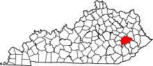 | |
| Unincorporated communities | ||
This article is issued from
Wikipedia.
The text is licensed under Creative Commons - Attribution - Sharealike.
Additional terms may apply for the media files.