Hazel Green, Kentucky
| Hazel Green | |
|---|---|
| Unincorporated community & census-designated place | |
| Nickname(s): Trimble's Store | |
 Hazel Green Location within the state of Kentucky  Hazel Green Hazel Green (the US) | |
| Coordinates: 37°47′51″N 83°25′0″W / 37.79750°N 83.41667°WCoordinates: 37°47′51″N 83°25′0″W / 37.79750°N 83.41667°W | |
| Country | United States |
| State | Kentucky |
| County | Wolfe |
| Elevation | 922 ft (281 m) |
| Time zone | UTC-5 (Eastern (EST)) |
| • Summer (DST) | UTC-4 (EDT) |
| ZIP codes | 41332 |
| GNIS feature ID | 493953 |
Hazel Green (also Tribles Store) is a census-designated place and unincorporated community in Wolfe County, Kentucky, United States. It lies along Routes 191 and 205 northeast of the city of Campton, the county seat of Wolfe County.[1] Its elevation is 922 feet (281 m).[2] Although it is unincorporated, it has a post office, with the ZIP code of 41332.[3]
A post office was established as Hazle Green [sic] in 1829, and named for the hazel shrubs prevalent in the area. The name of the post office was officially changed to its present spelling in 1889.[4]
Notable person
- Pete Center, baseball player.
- South Trimble U.S. House of Representatives -Longest serving Clerk of the House of Representatives
References
- ↑ Rand McNally. The Road Atlas '06. Chicago: Rand McNally, 2006, p. 43.
- ↑ U.S. Geological Survey Geographic Names Information System: Hazel Green, Kentucky, Geographic Names Information System, 1979-09-20. Accessed 2008-01-03.
- ↑ Zip Code Lookup
- ↑ Rennick, Robert M. (1987). Kentucky Place Names. University Press of Kentucky. p. 135. Retrieved 2013-04-28.
External links
- Digitized images from the Pearl Day Bach Photographic Collection, 1893-1961 housed at the University of Kentucky Libraries Special Collections Research Center
Municipalities and communities of Wolfe County, Kentucky, United States | ||
|---|---|---|
| City | 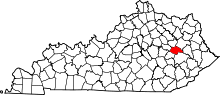 | |
| CDP | ||
| Other unincorporated communities | ||
This article is issued from
Wikipedia.
The text is licensed under Creative Commons - Attribution - Sharealike.
Additional terms may apply for the media files.