Harveyton, Kentucky
| Harveyton | |
|---|---|
| Unincorporated community | |
 Harveyton Location within the state of Kentucky  Harveyton Harveyton (the US) | |
| Coordinates: 37°18′44″N 83°12′6″W / 37.31222°N 83.20167°WCoordinates: 37°18′44″N 83°12′6″W / 37.31222°N 83.20167°W | |
| Country | United States |
| State | Kentucky |
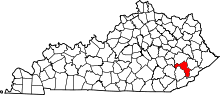
| County | Perry |
| Elevation | 1,020 ft (310 m) |
| Time zone | UTC-5 (Eastern (EST)) |
| • Summer (DST) | UTC-4 (EDT) |
| GNIS feature ID | 493852[1] |
Harveyton is an unincorporated community located in Perry County, Kentucky, United States.
The coal town was built around the Harvey Coal Company mine. A post office was established in 1916 with the name Staub; it was renamed Harveyton in 1923.[2] Its post office [3] has since closed.
References
- ↑ U.S. Geological Survey Geographic Names Information System: Harveyton, Kentucky
- ↑ Rennick, Robert M. (1987). Kentucky Place Names. University Press of Kentucky. p. 133. Retrieved 2013-04-28.
- ↑ U.S. Geological Survey Geographic Names Information System: Harveyton, Kentucky
This article is issued from
Wikipedia.
The text is licensed under Creative Commons - Attribution - Sharealike.
Additional terms may apply for the media files.