Kealakekua, Hawaii
| Kealakekua, Hawaii | |
|---|---|
| Census-designated place | |
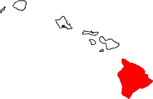
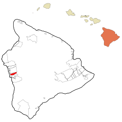 Location in Hawaii County and the state of Hawaii | |
| Coordinates: 19°31′35″N 155°55′22″W / 19.52639°N 155.92278°WCoordinates: 19°31′35″N 155°55′22″W / 19.52639°N 155.92278°W | |
| Country | United States |
| State | Hawaii |
| County | Hawaii |
| Area | |
| • Total | 7.2 sq mi (18.7 km2) |
| • Land | 7.2 sq mi (18.7 km2) |
| • Water | 0.0 sq mi (0.0 km2) |
| Elevation | 1,427 ft (435 m) |
| Population (2010) | |
| • Total | 2,019 |
| • Density | 279/sq mi (107.8/km2) |
| Time zone | UTC−10 (Hawaii–Aleutian) |
| ZIP code | 96750 |
| Area code(s) | 808 |
| FIPS code | 15-33950 |
| GNIS feature ID | 0360942 |
Kealakekua is a census-designated place (CDP) in Hawaiʻi County, Hawaiʻi, United States. The population was 2,019 at the 2010 census,[1] up from 1,645 at the 2000 census.
It was the subject of the 1933 popular song, "My Little Grass Shack in Kealakekua, Hawaii" by Bill Cogswell, Tommy Harrison and Johnny Noble, which became a Hawaiian music standard.
Geography
Kealakekua is located on the west side of the island of Hawaii at 19°31′35″N 155°55′22″W / 19.52639°N 155.92278°W (19.526436, -155.922891).[2] It is bordered to the north by Honalo and to the south by Captain Cook. Hawaii Route 11 is the main road through the community, leading north 10 miles (16 km) to Kailua-Kona and south 49 miles (79 km) to Naalehu.
According to the United States Census Bureau, the CDP has a total area of 7.2 square miles (18.7 km2), all of it land.[1]
Demographics
As of the census[3] of 2000, there were 1,645 people, 639 households, and 423 families residing in the CDP. The population density was 218.1 people per square mile (84.2/km²). There were 692 housing units at an average density of 91.7 per square mile (35.4/km²). The racial makeup of the CDP was 24.74% White, 0.73% African American, 0.67% Native American, 36.84% Asian, 7.23% Pacific Islander, 2.07% from other races, and 27.72% from two or more races. Hispanic or Latino of any race were 9.18% of the population.
There were 639 households out of which 25.5% had children under the age of 18 living with them, 49.0% were married couples living together, 12.2% had a female householder with no husband present, and 33.8% were non-families. 26.9% of all households were made up of individuals and 9.2% had someone living alone who was 65 years of age or older. The average household size was 2.57 and the average family size was 3.10.
In the CDP the population was spread out with 22.1% under the age of 18, 7.7% from 18 to 24, 25.3% from 25 to 44, 27.5% from 45 to 64, and 17.3% who were 65 years of age or older. The median age was 42 years. For every 100 females, there were 91.5 males. For every 100 females age 18 and over, there were 89.2 males.
The median income for a household in the CDP was $38,026, and the median income for a family was $45,192. Males had a median income of $29,333 versus $25,000 for females. The per capita income for the CDP was $21,495. About 9.2% of families and 13.7% of the population were below the poverty line, including 17.1% of those under age 18 and 6.3% of those age 65 or over.
Education
The Hawaii Department of Education operates public schools. Konawaena Middle School and Konawaena High School are located in the CDP.[4][5] Kona Pacific Public Charter School, founded in 2008, serves students in kindergarten through Grade 8.
Notable people
- Harry Kiyoshi Ishisaka (1927-1978), important figure in the development of aikido in southern California
- Keala Keanaaina (born 1973), American football player
- Henry Ōpūkaha`ia (1792–1818), a resident of Kealakekua, at 15 years old Ōpūkaha`ia boarded the Triumph to New Haven, Connecticut, where he was educated at Yale and was the impetus for Christian missionaries' arrival in Hawaii in 1820
- Ellison Shoji Onizuka (1946-1986), American astronaut lost in the destruction of Space Shuttle Challenger
- Douglas A. Zembiec (1973-2007), U.S. Marine Corps officer, Iraq and Afghanistan veteran, Silver Star, Bronze Star and two-time Purple Heart recipient
See also
- Kealakekua Bay, where the British explorer Captain James Cook was killed
References
- 1 2 "Geographic Identifiers: 2010 Demographic Profile Data (G001): Kealakekua CDP, Hawaii". American Factfinder. U.S. Census Bureau. Retrieved May 31, 2017.
- ↑ "US Gazetteer files: 2010, 2000, and 1990". United States Census Bureau. 2011-02-12. Retrieved 2011-04-23.
- ↑ "American FactFinder". United States Census Bureau. Retrieved 2008-01-31.
- ↑ "Kealakekua CDP, Hawaii." U.S. Census Bureau. Retrieved on May 21, 2009.
- ↑ "Map to Konawaena High School Archived 2008-11-18 at the Wayback Machine.." Konawaena High School. Retrieved on May 21, 2009.