Kasos
| Κάσος Kasos | |
|---|---|
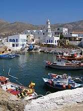 Old Harbor of Fry | |
 Κάσος Location within the region 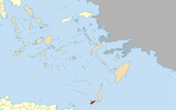 | |
| Coordinates: 35°24′N 26°55′E / 35.400°N 26.917°ECoordinates: 35°24′N 26°55′E / 35.400°N 26.917°E | |
| Country | Greece |
| Administrative region | South Aegean |
| Regional unit | Karpathos |
| Area | |
| • Municipality | 69.464 km2 (26.820 sq mi) |
| Highest elevation | 550 m (1,800 ft) |
| Lowest elevation | 0 m (0 ft) |
| Population (2011: 1084) | |
| • Municipality | 1,084 |
| • Municipality density | 16/km2 (40/sq mi) |
| Time zone | UTC+2 (EET) |
| • Summer (DST) | UTC+3 (EEST) |
| Postal code | 85800 |
| Area code(s) | 22450 |
| Vehicle registration | ΚΧ, ΡΟ, ΡΚ |
| Website | www.kasos.gr |
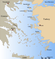
Kasos (/ˈkɑːsoʊs/; Greek: Κάσος, pronounced [ˈka̠so̞s]), also Casos, is a Greek island municipality in the Dodecanese. It is the southernmost island in the Aegean Sea, and is part of the Karpathos regional unit. As of 2011, its population was 1084. The island is known in Italian as Caso.[1]
Geography
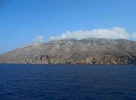
Kasos lies southwest of Karpathos, between this island and Crete. Adjacent to the island is the Strait of Kasos, through which some of the Modified Atlantic Water enters the Sea of Crete.[2] Its shape is elliptic and resembles that of Rhodes. The main island has a surface of 49 square kilometres (19 sq mi), and it is 17 km (11 mi) long and 6 km (4 mi) wide.[3] It is very mountainous, its highest mount being Mt. Prionas, which is 550 metres (1,800 feet) high.[3] There is fresh water on the island.[3]
The municipality of Kasos includes several uninhabited offshore islands, the largest of which are Armathia and Makronisi. Its total land area is 69.464 square kilometres (26.820 sq mi).[4] It has five villages, Fry (pronounced like "free", pop. 47), Agia Marina (14), Panagia (18), Poli (78), and Arvanitochori (169). Fry is the capital and home to the island's harbor, Agia Marina is most populous village. The airport is located close to Fry and is big enough for an ATR 42 to land.
Kasos is notable for its lack of large scale tourism, the quality of its fish, cheeses, and other culinary specialties, and its hospitality toward visitors.
History
In ancient times, Kasos (then known as Amphie, Astrabe, and, most commonly, Achnis) was used as a safe harbor by the Philistines. The first known settlements are Minoan and Mycenaean in origin.[5] According to Homer (Iliad, 2.676), Kasos contributed ships toward the Trojan War.
During Classical Antiquity it closely followed the history of nearby Karpathos.[1] Along with Karpathos, it was subjected from 1306 until 1537 to the Venetian Cornaro family[1], then belonged to the Ottoman Empire.
Kasos had been the first island to declare independence during the Greek Revolution and supported the cause with its fleet of ships. In 1824, Mehmet Ali Pasha of Egypt, furious with the Kasiots, dispatched his fleet to the island. The Egyptian armada burned the entire island and killed most of the population.[6][7]
The island's population recovered as did its economy, still largely based on shipping. The introduction of steam ships made Kasos' shipyard (which produced wooden sailing ships) redundant and its economy suffered accordingly. Beginning in the later half of the 19th century, many emigrated from Kasos, initially to Egypt (about 5,000 people), then to Istanbul, Greece, USA and South Africa. By the 1920s, out of about 2,300 houses on the island, only 400 were permanently inhabited.[1]
On 12 May 1912, during the Italo-Turkish War of 1911-12, after the so-called "Battle of Cassos" that took place on 29 January 1912, the island was occupied by the sailors of the Regia Marina ship Regina Elena.[1] With the Treaty of Lausanne of 1923, Kasos joined the other islands of the Dodecanese in the Italian possession of the Italian Aegean Islands, and was ceded by Italy to Greece with the Paris Peace Treaties of 1947. The island formally joined the Kingdom of Greece on 7 March 1948 together with the other Dodecanese islands.
Notable residents
- Kassia (revered in the Eastern Orthodox Church as St. Kassiane), a Byzantine abbess, poet, composer, and hymnographer.
See also
References
- 1 2 3 4 5 Bertarelli, 139
- ↑ Peter Saundry, C.Michael Hogan & Steve Baum. 2011. Sea of Crete. Encyclopedia of Earth. Eds.M.Pidwirny & C.J.Cleveland. National Council for Science and Environment. Washington DC.
- 1 2 3 Bertarelli, 138
- ↑ "Population & housing census 2001 (incl. area and average elevation)" (PDF) (in Greek). National Statistical Service of Greece. Archived from the original (PDF) on 2015-09-21.
- ↑ "MINOAN AND MYCENAEAN SETTLEMENT IN KASOS AND KARPATHOS". Bulletin of the Institute of Classical Studies. 30: 53–61. 2010-03-12. doi:10.1111/j.2041-5370.1983.tb00435.x. Retrieved 2013-03-26.
- ↑ Paul D. Hellander, Greece, pg 530
- ↑ "Κάσος: Τουρκοκρατία και Ολοκαύτωμα". Insitu.gr. Retrieved 2013-03-26.
Sources
- Bertarelli, L.V. (1929). Guida d'Italia, Vol. XVII. Consociazione Turistica Italiana, Milano. .
External links
- Official website (in English) (in Greek)
| Regional unit of Andros | 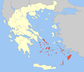 | |
|---|---|---|
| Regional unit of Kalymnos | ||
| Regional unit of Karpathos | ||
| Regional unit of Kea-Kythnos | ||
| Regional unit of Kos | ||
| Regional unit of Milos | ||
| Regional unit of Mykonos | ||
| Regional unit of Naxos | ||
| Regional unit of Paros | ||
| Regional unit of Rhodes | ||
| Regional unit of Syros | ||
| Regional unit of Thira | ||
| Regional unit of Tinos | ||