Donousa
| Donousa Δονούσα | |
|---|---|
 | |
 Donousa Location within the regional unit 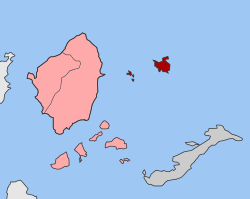 | |
| Coordinates: 37°06′N 25°48′E / 37.100°N 25.800°ECoordinates: 37°06′N 25°48′E / 37.100°N 25.800°E | |
| Country | Greece |
| Administrative region | South Aegean |
| Regional unit | Naxos |
| Municipality | Naxos and Lesser Cyclades |
| • Municipal unit | 13.750 km2 (5.309 sq mi) |
| Highest elevation | 385 m (1,263 ft) |
| Lowest elevation | 0 m (0 ft) |
| Population (2011)[1] | |
| • Municipal unit | 167 |
| • Municipal unit density | 12/km2 (31/sq mi) |
| Time zone | UTC+2 (EET) |
| • Summer (DST) | UTC+3 (EEST) |
| Postal code | 843 00 |
| Area code(s) | 22850 |
| Vehicle registration | EM |
| Website |
www |
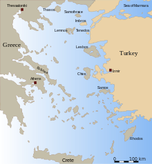
Donousa (Greek: Δονούσα, also Δενούσα Denousa) is an island and a former community in the Cyclades, Greece. Since the 2011 local government reform it is part of the municipality Naxos and Lesser Cyclades, of which it is a municipal unit.[2] Donousa is the easternmost island of the Lesser Cyclades.
Geography
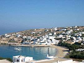
Donousa is located 16 km (10 mi) east of the island of Naxos and about 25 km (16 mi) north of Amorgos. Its area is 13.75 square kilometres (5.31 sq mi)[3] and its highest point is 385 metres (1,263 ft). Its population is 167 inhabitants (2011 census), most of which live in the main settlement Donousa (also Stavros). Other villages include Mersini (on the southeastern coast), Kalotaritissa (near its northern coastline) and Charavgi (in the south).
| Historical population | ||
|---|---|---|
| Year | Pop. | ±% p.a. |
| 1928 | 235 | — |
| 1946 | 250 | +0.34% |
| 1981 | 116 | −2.17% |
| 1991 | 111 | −0.44% |
| 2001 | 163 | +3.92% |
| 2011 | 167 | +0.24% |
References
- ↑ "Απογραφή Πληθυσμού - Κατοικιών 2011. ΜΟΝΙΜΟΣ Πληθυσμός" (in Greek). Hellenic Statistical Authority.
- ↑ Kallikratis law Greece Ministry of Interior (in Greek)
- ↑ "Population & housing census 2001 (incl. area and average elevation)" (PDF) (in Greek). National Statistical Service of Greece. Archived from the original (PDF) on 2015-09-21.
| Authority control |
|---|
This article is issued from
Wikipedia.
The text is licensed under Creative Commons - Attribution - Sharealike.
Additional terms may apply for the media files.