Fournoi Korseon
| Fournoi Korseon Φούρνοι Κορσέων | |
|---|---|
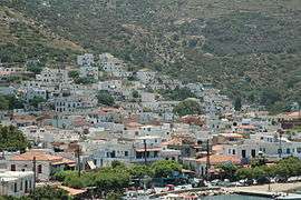 The main village | |
 Fournoi Korseon Location within the region 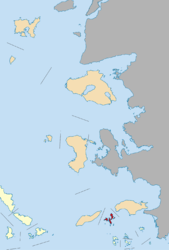 | |
| Coordinates: 37°34′N 26°30′E / 37.567°N 26.500°ECoordinates: 37°34′N 26°30′E / 37.567°N 26.500°E | |
| Country | Greece |
| Administrative region | North Aegean |
| Regional unit | Ikaria |
| Area | |
| • Municipality | 45.247 km2 (17.470 sq mi) |
| Population (2011)[1] | |
| • Municipality | 1,459 |
| • Municipality density | 32/km2 (84/sq mi) |
| Time zone | UTC+2 (EET) |
| • Summer (DST) | UTC+3 (EEST) |
| Postal code | 833 xx |
| Area code(s) | 22750 |
| Vehicle registration | MO |
| Website | www.fournikorseon.gr |
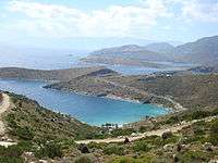
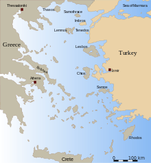
Fournoi Korseon (Greek: Φούρνοι Κορσέων or Greek: Φούρνοι Ικαρίας - Fournoi Ikarias), more commonly simply Fournoi, is a complex or archipelago of small Greek islands that lie between Ikaria, Samos and Patmos in Ikaria regional unit, North Aegean region. The two largest islands of the complex, the main isle of Fournoi 31 square kilometres (12 square miles) and the isle of Thymaina 10 square kilometres (3.9 square miles), are inhabited, as is Agios Minas Island 2.3 square kilometres (0.9 square miles) to the east. The municipality has an area of 45.247 km2.[2] On the main isle Fournoi (town) is the largest settlement and then Chrysomilia in the north the second largest (and third largest overall, after Thymaina). Fournoi (town) proper is the main ferry harbour, with ferries also landing on Thymaina.
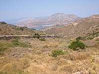
Many of the inhabitants are fishermen, although during the summer season the population is also occupied in tourist activities, mostly room rentals and catering. On the main island are a number of beaches such as Vlychada, Vitsilia, Petrokopio, Elidaki, and Bali.
The archipelago is famous for being a hub of Ancient World, which resulted in 53 shipwrecks found in the area until 2017.[3]
Climate
The climate is arid and hot during summers. Winters are rather mild with average rainfall but constant strong archipelagic winds prevail.
Communication
Communication is often interrupted during the winter period (mostly from November to April) due to bad weather, mainly strong winds. The rest of the year regular communication with the islands of Ikaria and Samos (by boat only) is available. Since 2008 a ferry coming from Samos reaches Athens stopping also in Icaria and Paros.
Settlements and islands
The main island of Fournoi has a population of 1,320 (as of the 2011 census), or over 90 percent of the municipality's population. The only other inhabited islands are Agios Minas, and Thymaina.
| Settlement or Place | Population | Island |
|---|---|---|
| Agios Minas | 3 | Agios Minas Island |
| Alatonisi | 0 | Alatonisi Island |
| Anthropofas | 0 | Anthropofas Island |
| Agios Ioannis Thermastis | 1 | Fournoi Island |
| Bali | 6 | Fournoi Island |
| Chrysomilea | 104 | Fournoi Island |
| Dafnolies | 2 | Fournoi Island |
| Fournoi | 1,120 | Fournoi Island |
| Kamari | 14 | Fournoi Island |
| Kampi Fournon | 15 | Fournoi Island |
| Kampi Chrysomileas | 50 | Fournoi Island |
| Kerameidou | 7 | Fournoi Island |
| Plagia | 1 | Fournoi Island |
| Kisiria | 0 | Kisiria Island |
| Makronisi | 0 | Makronisi Island |
| Mikros Anthropofas | 0 | Mikros Anthropofas Island |
| Petrokaravo | 0 | Petrokaravo Island |
| Plaka | 0 | Plaka Island |
| Plakaki | 0 | Plakaki Island |
| Strongylo | 0 | Strongylo Island |
| Thymaina | 136 | Thymaina Island |
| Thymainaki | 0 | Thymainaki Island |
References
- ↑ "Απογραφή Πληθυσμού - Κατοικιών 2011. ΜΟΝΙΜΟΣ Πληθυσμός" (in Greek). Hellenic Statistical Authority.
- ↑ "Population & housing census 2001 (incl. area and average elevation)" (PDF) (in Greek). National Statistical Service of Greece. Archived from the original (PDF) on 2015-09-21.
- ↑ "Shipwrecks Identify Fournoi as Significant Hub of Ancient World". gtp. 14 July 2017.
| Wikimedia Commons has media related to Fourni. |
External links
| Regional unit of Chios | 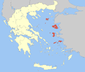 | |
|---|---|---|
| Regional unit of Ikaria | ||
| Regional unit of Lemnos | ||
| Regional unit of Lesbos | ||
| Regional unit of Samos | ||
| ||