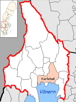
Karlstad Municipality
| Karlstad Municipality Karlstads kommun | ||
|---|---|---|
| Municipality | ||
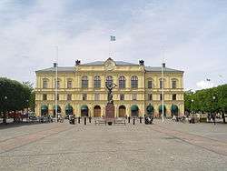 Karlstad Courthouse | ||
| ||
 | ||
| Country | Sweden | |
| County | Värmland County | |
| Seat | Karlstad | |
| Government | ||
| • Chairman of City Executive Board | Per-Samuel Nisser (M) | |
| • Deputy Chairs of City Executive Board | Linda Larsson (S) and Maria Frisk (MP) | |
| Area[1] | ||
| • Total | 1,517.74 km2 (586.00 sq mi) | |
| • Land | 1,169.11 km2 (451.40 sq mi) | |
| • Water | 348.63 km2 (134.61 sq mi) | |
| Area as of 1 January 2014. | ||
| Population (31 December 2017)[2] | ||
| • Total | 91,120 | |
| • Density | 60/km2 (160/sq mi) | |
| Time zone | UTC+1 (CET) | |
| • Summer (DST) | UTC+2 (CEST) | |
| ISO 3166 code | SE | |
| Province | Värmland | |
| Municipal code | 1780 | |
| Website | www.karlstad.se | |

Karlstad Municipality (Karlstads kommun) is a municipality in Värmland County in west central Sweden. Its seat is located in the city of Karlstad.
The present municipality was established in 1971 when the former City of Karlstad was amalgamated with a number of surrounding rural municipalities.
Localities
Politics
Municipalities are responsible for government-mandated duties, and elections for the Municipal council are held every four years, parallel to the general elections.
The inhabitants of Karlstad have a tendency to vote close to the national results at the general elections, making it the generally accepted Bellwether town of Sweden.[3][4]
Elections
Riksdag
These are the local results of the Riksdag elections since the 1972 municipality reform. The results of the Sweden Democrats were not published by SCB between 1988 and 1998 at a municipal level to the party's small nationwide size at the time. "Votes" denotes valid votes, whereas "Turnout" denotes also blank and invalid votes.
| Year | Turnout | Votes | V | S | MP | C | L | KD | M | SD | ND |
|---|---|---|---|---|---|---|---|---|---|---|---|
| 1973[5] | 92.0 | 47,969 | 4.2 | 45.0 | 0.0 | 24.3 | 10.1 | 0.8 | 15.0 | 0.0 | 0.0 |
| 1976[6] | 92.6 | 50,261 | 3.8 | 41.8 | 0.0 | 22.6 | 12.1 | 0.5 | 18.8 | 0.0 | 0.0 |
| 1979[7] | 91.6 | 51,435 | 4.8 | 43.5 | 0.0 | 16.1 | 10.0 | 0.6 | 24.2 | 0.0 | 0.0 |
| 1982[8] | 92.2 | 52,341 | 5.0 | 46.4 | 1.8 | 13.2 | 5.7 | 1.0 | 26.9 | 0.0 | 0.0 |
| 1985[9] | 90.5 | 52,538 | 4.8 | 45.2 | 1.9 | 9.2 | 14.6 | 0.0 | 24.3 | 0.0 | 0.0 |
| 1988[10] | 85.8 | 50,120 | 5.2 | 44.4 | 5.2 | 10.4 | 12.6 | 1.8 | 20.1 | 0.0 | 0.0 |
| 1991[11] | 87.5 | 51,742 | 4.2 | 37.5 | 3.3 | 7.2 | 9.5 | 7.0 | 23.7 | 0.0 | 7.0 |
| 1994[12] | 88.0 | 52,738 | 6.4 | 44.4 | 4.9 | 6.3 | 8.3 | 3.8 | 24.3 | 0.0 | 1.1 |
| 1998[13] | 82.8 | 50,206 | 12.7 | 36.4 | 4.9 | 4.1 | 4.7 | 12.0 | 23.2 | 0.0 | 0.0 |
| 2002[14] | 82.0 | 51,272 | 7.9 | 39.9 | 4.8 | 5.7 | 14.2 | 8.6 | 15.2 | 1.4 | 0.0 |
| 2006[15] | 83.6 | 53,554 | 6.0 | 36.8 | 5.5 | 7.5 | 7.7 | 6.5 | 25.2 | 2.3 | 0.0 |
| 2010[16] | 86.1 | 57,709 | 5.5 | 32.9 | 8.0 | 5.5 | 7.5 | 5.3 | 29.9 | 4.2 | 0.0 |
| 2014[17] | 87.7 | 61,111 | 5.5 | 34.7 | 7.8 | 5.7 | 5.3 | 4.5 | 23.3 | 9.6 | 0.0 |
| 2018[18] | 89.0 | 63,334 | 7.9 | 31.7 | 4.8 | 8.5 | 5.7 | 6.4 | 19.5 | 14.1 | 0.0 |
Blocs
This lists the relative strength of the socialist and centre-right blocs since 1973, but parties not elected to the Riksdag are inserted as "other", including the Sweden Democrats results from 1988 to 2006, but also the Christian Democrats pre-1991 and the Greens in 1982, 1985 and 1991. The sources are identical to the table above. The coalition or government mandate marked in bold formed the government after the election. New Democracy got elected in 1991 but are still listed as "other" due to the short lifespan of the party. "Elected" is the total number of percentage points from the municipality that went to parties who were elected to the Riksdag.
| Year | Turnout | Votes | Left | Right | SD | Other | Elected |
|---|---|---|---|---|---|---|---|
| 1973 | 92.0 | 47,969 | 49.2 | 49.4 | 0.0 | 1.4 | 98.6 |
| 1976 | 92.6 | 50,261 | 45.6 | 53.5 | 0.0 | 0.9 | 99.1 |
| 1979 | 91.6 | 51,435 | 48.3 | 50.3 | 0.0 | 1.4 | 98.6 |
| 1982 | 92.2 | 52,341 | 51.4 | 45.8 | 0.0 | 2.8 | 97.2 |
| 1985 | 90.5 | 52,538 | 50.0 | 48.1 | 0.0 | 1.9 | 98.1 |
| 1988 | 85.8 | 50,120 | 54.8 | 43.1 | 0.0 | 2.1 | 97.9 |
| 1991 | 87.5 | 51,742 | 41.7 | 47.4 | 0.0 | 11.9 | 96.1 |
| 1994 | 88.0 | 52,738 | 55.7 | 42.7 | 0.0 | 1.6 | 98.4 |
| 1998 | 82.8 | 50,206 | 54.0 | 44.0 | 0.0 | 2.0 | 98.0 |
| 2002 | 82.0 | 51,272 | 52.6 | 43.7 | 0.0 | 3.7 | 96.3 |
| 2006 | 83.6 | 53,554 | 48.3 | 46.9 | 0.0 | 4.8 | 95.2 |
| 2010 | 86.1 | 57,709 | 46.4 | 48.2 | 4.2 | 1.2 | 98.8 |
| 2014 | 87.7 | 61,111 | 48.0 | 38.8 | 9.6 | 3.6 | 96.4 |
| 2018 | 89.0 | 63,334 | 44.5 | 40.1 | 14.1 | 1.5 | 98.5 |
Notable natives
- Bengt Alsterlind, TV host ("Hajk")
- Zarah Leander, singer
- Sven-Erik Magnusson, singer/dance band artist (Sven-Ingvars)
- Christer Sjögren, rock/dansband singer (Vikingarna)
- Ulf Sterner, ice hockey player (first Swede to play in the National Hockey League)
- Elgen Helge, local hero (Most handsome moose around)
Sites of interest
- Alsters herrgård, the manor house where Gustaf Fröding was born
- Karlstad Church, built in 1730
- An indoor ice rink and event arena, Löfbergs Arena, expanded in 2002 to host the Ice Hockey World Championships
- Botanical gardens
- The masonic lodge where the negotiations for the dissolution of the union between Sweden and Norway were held in 1905
- A runestone Vr 2, one of four known in Värmland
- A history museum
- A nature museum
International relations
Twin towns — Sister cities
See also
References
- ↑ "Statistiska centralbyrån, Kommunarealer den 1 januari 2014" (Microsoft Excel) (in Swedish). Statistics Sweden. Retrieved 2014-04-18.
- ↑ "Folkmängd i riket, län och kommuner 31 december 2017" (in Swedish). Statistics Sweden. February 21, 2018. Retrieved February 21, 2018.
- ↑ "Karlstad röstar som Sverige | Forskning & Framsteg | Populärvetenskapligt magasin". Fof.se. Retrieved 2011-09-16.
- ↑ "Som Ljungby röstar – röstar inte Sverige – Statistiska centralbyrån". Scb.se. 2006-03-06. Retrieved 2011-09-16.
- ↑ "Riksdagsvalet 1973 (page 166)" (PDF) (in Swedish). SCB. Retrieved 14 September 2017.
- ↑ "Riksdagsvalet 1976 (page 161)" (PDF) (in Swedish). SCB. Retrieved 14 September 2017.
- ↑ "Riksdagsvalet 1979 (page 185)" (PDF) (in Swedish). SCB. Retrieved 14 September 2017.
- ↑ "Riksdagsvalet 1982 (page 186)" (PDF) (in Swedish). SCB. Retrieved 14 September 2017.
- ↑ "Riksdagsvalet 1985 (page 187)" (PDF) (in Swedish). SCB. Retrieved 14 September 2017.
- ↑ "Riksdagsvalet 1988 (page 167)" (PDF) (in Swedish). SCB. Retrieved 14 September 2017.
- ↑ "Riksdagsvalet 1991 (page 29)" (PDF) (in Swedish). SCB. Retrieved 14 September 2017.
- ↑ "Riksdagsvalet 1994 (page 43)" (PDF) (in Swedish). SCB. Retrieved 14 September 2017.
- ↑ "Riksdagsvalet 1998 (page 40)" (PDF) (in Swedish). SCB. Retrieved 14 September 2017.
- ↑ "Valresultat Riksdag Karlstads kommun 2002" (in Swedish). Valmyndigheten. Retrieved 14 September 2017.
- ↑ "Valresultat Riksdag Karlstads kommun 2006" (in Swedish). Valmyndigheten. Retrieved 14 September 2017.
- ↑ "Valresultat Riksdag Karlstads kommun 2010" (in Swedish). Valmyndigheten. Retrieved 14 September 2017.
- ↑ "Valresultat Riksdag Karlstads kommun 2014" (in Swedish). Valmyndigheten. Retrieved 14 September 2017.
- ↑ "Valresultat Riksdag Karlstads kommun 2018" (in Swedish). Valmyndigheten. Retrieved 23 September 2018.
- ↑ http://www.karlstad.se/apps/symfoni/karlstad/karlstad.nsf/$all/9A40A50D6915C543C125743A004A06E6
- ↑ "Välissuhted" (in Estonian). Jõgeva linn. Retrieved 2011-07-23.
External links
| Wikimedia Commons has media related to Karlstad Municipality. |
- Karlstad Municipality - Official site
- Karlstad University
Municipalities and seats of Värmland County | ||
|---|---|---|
| Municipalities | ||
| Municipal seats | ||