Munkfors Municipality
| Munkfors Municipality Munkfors kommun | ||
|---|---|---|
| Municipality | ||
| ||
 | ||
| Country | Sweden | |
| County | Värmland County | |
| Seat | Munkfors | |
| Area[1] | ||
| • Total | 147.97 km2 (57.13 sq mi) | |
| • Land | 141.58 km2 (54.66 sq mi) | |
| • Water | 6.39 km2 (2.47 sq mi) | |
| Area as of 1 January 2014. | ||
| Population (31 December 2017)[2] | ||
| • Total | 3,763 | |
| • Density | 25/km2 (66/sq mi) | |
| Time zone | UTC+1 (CET) | |
| • Summer (DST) | UTC+2 (CEST) | |
| ISO 3166 code | SE | |
| Province | Värmland | |
| Municipal code | 1762 | |
| Website | www.munkfors.se | |

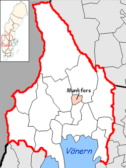
Munkfors Municipality (Munkfors kommun) is a municipality in Värmland County in west central Sweden. Its seat is located in the town of Munkfors.
In 1952 the rural municipality Ransäter got the title of a market town (köping) and the name Munkfors after its only built-up locality. With the local government reform of 1971 it became a municipality of unitary type without addition of territory. The municipality is today the 9th smallest by population in Sweden.
In Ransäter lies the Geijer School, in honour of author Erik Gustaf Geijer (1783-1843), who was born at the Ransäter farm. A second notable Ransäter native was Tage Erlander (1901-1985), who was Prime Minister of Sweden 1946-1969.
The municipality has one sister city: Lindsborg, Kansas, U.S.A.
Elections
Riksdag
These are the local results of the Riksdag elections since the 1972 municipality reform. The results of the Sweden Democrats were not published by SCB between 1988 and 1998 at a municipal level to the party's small nationwide size at the time. "Votes" denotes valid votes, whereas "Turnout" denotes also blank and invalid votes.
| Year | Turnout | Votes | V | S | MP | C | L | KD | M | SD | ND |
|---|---|---|---|---|---|---|---|---|---|---|---|
| 1973[3] | 94.6 | 3,933 | 4.7 | 67.7 | 0.0 | 15.5 | 6.3 | 1.0 | 4.4 | 0.0 | 0.0 |
| 1976[4] | 94.4 | 3,978 | 3.6 | 67.1 | 0.0 | 15.8 | 7.0 | 0.6 | 5.7 | 0.0 | 0.0 |
| 1979[5] | 94.2 | 3,871 | 4.8 | 67.4 | 0.0 | 13.7 | 5.3 | 0.5 | 8.0 | 0.0 | 0.0 |
| 1982[6] | 93.5 | 3,758 | 4.7 | 69.3 | 1.1 | 11.7 | 3.5 | 0.8 | 8.8 | 0.0 | 0.0 |
| 1985[7] | 90.6 | 3,599 | 4.9 | 68.7 | 0.9 | 9.4 | 7.8 | 0.0 | 8.1 | 0.0 | 0.0 |
| 1988[8] | 88.8 | 3,412 | 5.5 | 68.9 | 2.8 | 9.8 | 5.9 | 1.2 | 5.6 | 0.0 | 0.0 |
| 1991[9] | 88.2 | 3,326 | 6.1 | 63.0 | 1.6 | 8.7 | 5.4 | 3.2 | 7.8 | 0.0 | 3.5 |
| 1994[10] | 88.2 | 3,275 | 7.7 | 67.3 | 2.2 | 7.3 | 4.3 | 1.8 | 8.0 | 0.0 | 0.6 |
| 1998[11] | 81.3 | 2,798 | 16.4 | 57.1 | 2.3 | 5.7 | 2.9 | 6.1 | 8.1 | 0.0 | 0.0 |
| 2002[12] | 80.4 | 2,576 | 9.6 | 59.2 | 2.9 | 8.5 | 6.9 | 4.1 | 6.1 | 1.8 | 0.0 |
| 2006[13] | 80.7 | 2,492 | 9.1 | 55.8 | 2.4 | 9.7 | 5.5 | 2.7 | 9.5 | 3.2 | 0.0 |
| 2010[14] | 83.9 | 2,484 | 6.6 | 56.1 | 2.6 | 7.3 | 5.9 | 2.9 | 11.8 | 4.9 | 0.0 |
| 2014[15] | 85.1 | 2,463 | 4.6 | 58.1 | 2.1 | 6.2 | 3.5 | 2.0 | 9.7 | 11.4 | 0.0 |
Blocs
This lists the relative strength of the socialist and centre-right blocs since 1973, but parties not elected to the Riksdag are inserted as "other", including the Sweden Democrats results from 1988 to 2006, but also the Christian Democrats pre-1991 and the Greens in 1982, 1985 and 1991. The sources are identical to the table above. The coalition or government mandate marked in bold formed the government after the election. New Democracy got elected in 1991 but are still listed as "other" due to the short lifespan of the party. "Elected" is the total number of percentage points from the municipality that went to parties who were elected to the Riksdag.
| Year | Turnout | Votes | Left | Right | SD | Other | Elected |
|---|---|---|---|---|---|---|---|
| 1973 | 94.6 | 3,933 | 72.4 | 26.0 | 0.0 | 1.6 | 98.4 |
| 1976 | 94.4 | 3,978 | 70.7 | 28.5 | 0.0 | 0.8 | 99.2 |
| 1979 | 94.2 | 3,871 | 72.2 | 27.0 | 0.0 | 0.8 | 99.2 |
| 1982 | 93.5 | 3,758 | 74.0 | 24.0 | 0.0 | 2.0 | 98.0 |
| 1985 | 90.6 | 3,599 | 73.6 | 25.3 | 0.0 | 1.1 | 98.9 |
| 1988 | 88.8 | 3,412 | 77.2 | 21.3 | 0.0 | 1.5 | 98.5 |
| 1991 | 88.2 | 3,326 | 69.1 | 25.1 | 0.0 | 5.8 | 97.4 |
| 1994 | 88.2 | 3,275 | 77.2 | 21.4 | 0.0 | 1.4 | 98.6 |
| 1998 | 81.3 | 2,798 | 75.8 | 22.8 | 0.0 | 1.4 | 98.6 |
| 2002 | 80.4 | 2,576 | 71.7 | 25.6 | 0.0 | 2.7 | 97.3 |
| 2006 | 80.7 | 2,492 | 67.3 | 27.4 | 0.0 | 5.3 | 94.7 |
| 2010 | 83.9 | 2,484 | 65.3 | 27.9 | 4.9 | 1.9 | 98.1 |
| 2014 | 85.1 | 2,463 | 64.8 | 21.4 | 11.4 | 2.4 | 97.6 |
References
- ↑ "Statistiska centralbyrån, Kommunarealer den 1 januari 2014" (Microsoft Excel) (in Swedish). Statistics Sweden. Retrieved 2014-04-18.
- ↑ "Folkmängd i riket, län och kommuner 31 december 2017" (in Swedish). Statistics Sweden. February 21, 2018. Retrieved February 21, 2018.
- ↑ "Riksdagsvalet 1973 (page 166)" (PDF) (in Swedish). SCB. Retrieved 23 August 2017.
- ↑ "Riksdagsvalet 1976 (page 161)" (PDF) (in Swedish). SCB. Retrieved 23 August 2017.
- ↑ "Riksdagsvalet 1979 (page 185)" (PDF) (in Swedish). SCB. Retrieved 23 August 2017.
- ↑ "Riksdagsvalet 1982 (page 186)" (PDF) (in Swedish). SCB. Retrieved 23 August 2017.
- ↑ "Riksdagsvalet 1985 (page 187)" (PDF) (in Swedish). SCB. Retrieved 23 August 2017.
- ↑ "Riksdagsvalet 1988 (page 167)" (PDF) (in Swedish). SCB. Retrieved 23 August 2017.
- ↑ "Riksdagsvalet 1991 (page 29)" (PDF) (in Swedish). SCB. Retrieved 23 August 2017.
- ↑ "Riksdagsvalet 1994 (page 43)" (PDF) (in Swedish). SCB. Retrieved 23 August 2017.
- ↑ "Riksdagsvalet 1998 (page 40)" (PDF) (in Swedish). SCB. Retrieved 23 August 2017.
- ↑ "Valresultat Riksdag Munkfors kommun 2002" (in Swedish). Valmyndigheten. Retrieved 23 August 2017.
- ↑ "Valresultat Riksdag Munkfors kommun 2006" (in Swedish). Valmyndigheten. Retrieved 23 August 2017.
- ↑ "Valresultat Riksdag Munkfors kommun 2010" (in Swedish). Valmyndigheten. Retrieved 23 August 2017.
- ↑ "Valresultat Riksdag Munkfors kommun 2014" (in Swedish). Valmyndigheten. Retrieved 23 August 2017.
External links
- Munkfors Municipality - Official site
Municipalities and seats of Värmland County | ||
|---|---|---|
| Municipalities | ||
| Municipal seats | ||