Karlsøy
| Karlsøy kommune Gálssa suohkan | |||
|---|---|---|---|
| Municipality | |||
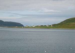
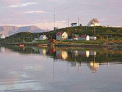 View of the Kåja island with Torsvåg Lighthouse off Vanna | |||
| |||
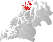 Karlsøy within Troms | |||
| Coordinates: 70°07′48″N 19°25′51″E / 70.13000°N 19.43083°ECoordinates: 70°07′48″N 19°25′51″E / 70.13000°N 19.43083°E | |||
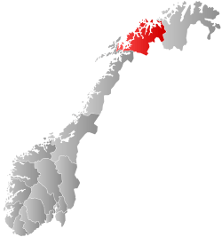
| Country | Norway | ||
| County | Troms | ||
| District | Nord-Troms | ||
| Established | 1 Jan 1838 | ||
| Administrative centre | Hansnes | ||
| Government | |||
| • Mayor (2011) | Hanny Ditlefsen (Ap) | ||
| Area | |||
| • Total | 1,091.59 km2 (421.47 sq mi) | ||
| • Land | 1,050.71 km2 (405.68 sq mi) | ||
| • Water | 40.88 km2 (15.78 sq mi) | ||
| Area rank | #93 in Norway | ||
| Population (2017) | |||
| • Total | 2,273 | ||
| • Rank | #309 in Norway | ||
| • Density | 2.2/km2 (6/sq mi) | ||
| • Change (10 years) | -3.0% | ||
| Demonym(s) | Karlsøyværing[1] | ||
| Time zone | UTC+01:00 (CET) | ||
| • Summer (DST) | UTC+02:00 (CEST) | ||
| ISO 3166 code | NO-1936 | ||
| Official language form | Neutral | ||
| Website |
karlsoy | ||

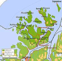
Karlsøy (Northern Sami: Gálssa suohkan) is an island municipality in Troms county, Norway. The administrative centre of the municipality is the village of Hansnes. Other villages include Dåfjord, Hessfjord, Karlsøya, Torsvåg, Vannvåg, and Vannareid. The municipality is made up of many islands including Ringvassøya, Reinøya, Vannøya, Karlsøya, and Rebbenesøya plus several uninhabited islands (many of which were formerly inhabited). Some of the currently uninhabited islands include Helgøya, Nordkvaløya, Grøtøya, and Nord-Fugløya.[2]
The 1,092-square-kilometre (422 sq mi) municipality is the 93rd largest by area out of the 422 municipalities in Norway. Karlsøy is the 309th most populous municipality in Norway with a population of 2,273. The municipality's population density is 2.2 inhabitants per square kilometre (5.7/sq mi) and its population has decreased by 3% over the last decade.[3]
General information
Karlsøy was established as a municipality on 1 January 1838 (see the formannskapsdistrikt law). On 1 January 1867, the southern Ullsfjord district of Karlsøy (population: 862) was transferred from Karlsøy to the neighboring Lyngen Municipality. On 1 September 1886, the western island district (population: 828) was separated from Karlsøy to become the new municipality of Helgøy. This left Karlsøy with 1,334 inhabitants.
During the 1960s, there were many municipal mergers across Norway due to the work of the Schei Committee. On 1 January 1964, the municipality of Helgøy was merged back into the municipality of Karlsøy. At the same time, all of the mainland areas of Karlsøy (the northern part of the Lyngen peninsula, with 1,001 inhabitants) was transferred from Karlsøy to neighboring Lyngen Municipality. After all the changes, the new Karlsøy had 3,414 residents. On 1 January 2008, the southern part of the island of Reinøya was transferred from Tromsø Municipality to Karlsøy Municipality.[4][5]
Name
The municipality (originally the parish) is named after the small Karlsøya island (Old Norse: Kalsøe), since the first Karlsøy Church was built there. The first element is the genitive case of the male name Karl and the last element is øy which means "island". Prior to 1909, the name was spelled Karlsø.[6]
Coat of arms
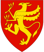
The coat of arms was granted on 12 December 1980. The arms show the head of a white-tailed eagle on a blue background, since one of Europe's largest colonies of these birds is found on the island of Nord-Fugløya in the municipality. Furthermore, the eagle symbolizes the importance of fishing for the municipality.[7]
Churches
The Church of Norway has one parish (sokn) within the municipality of Karlsøy. It is part of the Tromsø domprosti (arch-deanery) in the Diocese of Nord-Hålogaland.
| Parish (Sokn) | Church Name | Location of the Church | Year Built |
|---|---|---|---|
| Karlsøy | Helgøy Church | Helgøya | 1742 |
| Karlsøy Church | Karlsøya | 1854 | |
| Ringvassøy Church | Hansnes | 1977 | |
| Sengskroken Church | Vanna | 1962 |
Economy
Karlsøy is among the world's most important exporters of dried and salted cod, with Portugal, Spain, and Brazil among the main markets. The population is almost totally dependent on fishing. There are also goat herding businesses and some musicians that live on the island. There is also some tourism, including a festival that runs in the Summer. There are plans for 50 holiday homes to be built on the isle.
Geography and nature
The municipality consists of islands only. Ringvassøya, Norway's sixth largest island, is the largest island in the municipality. Nordkvaløya, Helgøya, Karlsøya, Vanna (Vannøya), Reinøya, and Rebbenesøya are the other major islands.
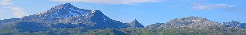
The islands of Rebbenesøy and Ringvassøy are split (as was Reinøya before 2008), with the southern part belonging to neighboring Tromsø municipality. The reason is that the borders were drawn when boat was the only means of transportation; then it made sense that the southern parts of the islands belonged to Tromsø while the northern parts belonged to Karlsøy. Today, when roads have replaced the boats, the situation is awkward, which is why the Norwegian government transferred all of Reinøy to the municipality of Karlsøy on 1 January 2008.[5] Soltindan is the highest mountain on the island of Ringvassøy at 1,051 m (3,448 ft) above sea level.
Karlsøya, the little island after which the municipality is named, has a village with the 19th century Karlsøy Church. The inhabitants include the original inhabitants, hippies, and Norwegian Muslims.
Helgøya, the former seat of the independent municipality of Helgøy in the western part of present Karlsøy, is today a more or less abandoned village of wooden houses and the old Helgøy Church. The island can only be reached when services are celebrated in the church, and ferry rides are organized.
Lake Skogsfjordvatn, in the centre of Ringvassøy, is a lake with some fishing, surrounded by sub-Arctic forests. This is Norway's largest lake in an island. The island of Vannøya has several villages, including Burøysund and Torsvåg, the latter offering views of the Atlantic from the Torsvåg Lighthouse.
| Climate data for Torsvåg | |||||||||||||
|---|---|---|---|---|---|---|---|---|---|---|---|---|---|
| Month | Jan | Feb | Mar | Apr | May | Jun | Jul | Aug | Sep | Oct | Nov | Dec | Year |
| Average high °C (°F) | 0.7 (33.3) |
0.6 (33.1) |
1.3 (34.3) |
3.2 (37.8) |
6.9 (44.4) |
10.8 (51.4) |
13.6 (56.5) |
13.2 (55.8) |
9.9 (49.8) |
6.3 (43.3) |
3.3 (37.9) |
1.5 (34.7) |
5.9 (42.6) |
| Daily mean °C (°F) | −1.1 (30) |
−1.2 (29.8) |
−0.5 (31.1) |
1.4 (34.5) |
4.8 (40.6) |
8.0 (46.4) |
10.8 (51.4) |
10.7 (51.3) |
7.9 (46.2) |
4.6 (40.3) |
1.6 (34.9) |
−0.3 (31.5) |
3.9 (39) |
| Average low °C (°F) | −2.9 (26.8) |
−3.0 (26.6) |
−2.2 (28) |
−0.3 (31.5) |
2.9 (37.2) |
6.0 (42.8) |
8.6 (47.5) |
8.8 (47.8) |
6.3 (43.3) |
3.0 (37.4) |
0.0 (32) |
−2.1 (28.2) |
2.1 (35.8) |
| Average precipitation mm (inches) | 73 (2.87) |
56 (2.2) |
57 (2.24) |
48 (1.89) |
45 (1.77) |
50 (1.97) |
52 (2.05) |
59 (2.32) |
76 (2.99) |
97 (3.82) |
80 (3.15) |
85 (3.35) |
778 (30.63) |
| Average precipitation days (≥ 1 mm) | 14.5 | 12.5 | 12.1 | 11.9 | 10.5 | 11.0 | 10.9 | 11.7 | 15.0 | 17.4 | 16.3 | 15.9 | 159.7 |
| Source: Norwegian Meteorological Institute[8] | |||||||||||||
Government
All municipalities in Norway, including Karlsøy, are responsible for primary education (through 10th grade), outpatient health services, senior citizen services, unemployment and other social services, zoning, economic development, and municipal roads. The municipality is governed by a municipal council of elected representatives, which in turn elect a mayor.[9] The municipality falls under the Nord-Troms District Court and the Hålogaland Court of Appeal.
Municipal council
The municipal council (Kommunestyre) of Karlsøy is made up of 17 representatives that are elected to four year terms. Currently, the party breakdown is as follows:[10]
| Party Name | Name in Norwegian | Number of representatives | |
|---|---|---|---|
| Labour Party | Arbeiderpartiet | 4 | |
| Progress Party | Fremskrittspartiet | 4 | |
| Conservative Party | Høyre | 1 | |
| Centre Party | Senterpartiet | 3 | |
| Socialist Left Party | Sosialistisk Venstreparti | 2 | |
| Local Lists | Lokale lister | 3 | |
| Total number of members: | 17 | ||
Transportation
The municipal centre is at Hansnes, which can be reached through an undersea tunnel from Tromsø, and the drive is about one hour. From here ferries depart to Vannøy, Reinøy, and Karlsøy. The Langsund Tunnel is under construction and was planned to be completed by 2015, but it is currently on hiatus. It is expected to connect the islands of Reinøya and Ringvassøy. The few inhabitants of Rebbenesøy are served by a ferry from Mikkelvik on the western side of Ringvassøy.
Attractions
Karlsøy attractions include:
- The island of Nord-Fugløya, one of Norway's major bird cliffs, including puffin colonies.
- Fugløykalven Lighthouse, northwest of Nord-Fugløya
- There is a flat high plateau on Nord-Fugløya, 600 m (2,000 ft) above sea level, where Arctic cloudberries grow. The island can only be reached in the cloudberry season, when picking expeditions are organized from Burøysund.
References
- ↑ "Navn på steder og personer: Innbyggjarnamn" (in Norwegian). Språkrådet. Retrieved 2015-12-01.
- ↑ Store norske leksikon. "Karlsøy" (in Norwegian). Retrieved 2012-12-16.
- ↑ Statistisk sentralbyrå (2017). "Table: 06913: Population 1 January and population changes during the calendar year (M)" (in Norwegian). Retrieved 2017-09-09.
- ↑ Jukvam, Dag (1999). "Historisk oversikt over endringer i kommune- og fylkesinndelingen" (PDF) (in Norwegian). Statistisk sentralbyrå.
- 1 2 "Søndre del av Reinøy i Troms overføres til Karlsøy kommune" (in Norwegian). Norwegian Ministry of Local Government and Regional Development. Retrieved 2008-12-04.
- ↑ Rygh, Oluf (1911). Norske gaardnavne: Troms amt (in Norwegian) (17 ed.). Kristiania, Norge: W. C. Fabritius & sønners bogtrikkeri. p. 162.
- ↑ "Civic heraldry of Norway - Norske Kommunevåpen". Heraldry of the World. Retrieved 2018-08-09.
- ↑ "eKlima Web Portal". Norwegian Meteorological Institute. Archived from the original on 2004-06-14.
- ↑ Hansen, Tore, ed. (2016-05-12). "kommunestyre". Store norske leksikon (in Norwegian). Kunnskapsforlaget. Retrieved 2018-08-07.
- ↑ "Table: 04813: Members of the local councils, by party/electoral list at the Municipal Council election (M)" (in Norwegian). Statistics Norway.
External links
| Wikimedia Commons has media related to Karlsøy. |
| Look up karlsøy in Wiktionary, the free dictionary. |
- Municipal fact sheet from Statistics Norway (in Norwegian)

- http://karlsoyfestival.com/
| |||||||||
| |||||||||
| |||||||||
| Authority control |
|---|