Dharamshala
| Dharamshala | |
|---|---|
| City | |
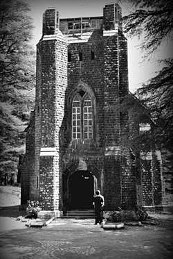
 Clockwise from top: Skyline of Dharamsala, Main Street Temple - McLeod Ganj, Gyuto Karmapa, Himachal Pradesh Cricket Association Stadium and St. John church | |
 Dharamshala Location in Himachal Pradesh, India  Dharamshala Dharamshala (Himachal Pradesh) | |
| Coordinates: 32°13′05″N 76°19′12″E / 32.218°N 76.320°ECoordinates: 32°13′05″N 76°19′12″E / 32.218°N 76.320°E | |
| Country |
|
| State | Himachal Pradesh |
| District | Kangra |
| Government | |
| Area[1] | |
| • Total | 27.60 km2 (10.66 sq mi) |
| Elevation | 1,457 m (4,780 ft) |
| Population (2011)[1] | |
| • Total | 30,764 |
| • Rank | 3 in HP |
| • Density | 1,100/km2 (2,900/sq mi) |
| Time zone | UTC+5:30 (IST) |
| PIN | 176 215 |
| Telephone code | +91-1892 |
| Vehicle registration | HP- HP 39, HP 68 |
| Climate | Cwa |
| Website |
www |
Dharamshala (also spelled Dharamsala) is the district headquarters of Kangra district in India. It was formerly known as Bhagsu. The Dalai Lama's residence and the headquarters of the Central Tibetan Administration (the Tibetan government in exile) are in Dharamshala. Dharamshala is 18 kilometers from Kangra.Dharamshala has been selected as one of the hundred Indian cities to be developed as a smart city under PM Narendra Modi's flagship Smart Cities Mission.[2].On 19 January 2017, Chief Minister Virbhadra Singh declared Dharamshala as the second capital of Himachal Pradesh state, making Himachal Pradesh the third state of India with two capitals after Jammu and Kashmir and Maharashtra.[3][4]
Description
Dharamshala is a municipal corporation city in the upper reaches of the Kangra Valley and is surrounded by dense coniferous forest consisting mainly of stately Deodar cedar trees. The suburbs include McLeod Ganj, Bhagsunath, Dharamkot, Naddi, ForsythGanj, Kotwali Bazaar (the main market), Kaccheri Adda (government offices such as the court, police, post, etc.), Dari, Ramnagar, Sidhpur, and Sidhbari (where the Karmapa is based). This place is also famous for its newly built cricket stadium which offers opportunities to the youth of state to prepare for their future in the game. The village of McLeodGanj, lying in the upper reaches, is known worldwide for the presence of the Dalai Lama. On 29 April 1959, the 14th Dalai Lama (Tenzin Gyatso) established the Tibetan exile administration in the north Indian hill station of Mussoorie. In May 1960, the Central Tibetan Administration (CTA) was moved to Dharamshala.Dharamshala is the centre of the Tibetan exile world in India. Following the 1959 Tibetan uprising there was an influx of Tibetan refugees who followed the 14th Dalai Lama. His presence and the Tibetan population have made Dharamshala a popular destination for Indian and foreign tourists, including students studying Tibet.Dharamshala also has beautiful tea gardens and its tea, known as Dharamsala or Kangra tea, is very popular across India and the rest of the world. Traditionally known for Kangra green tea, Dharamshala now produces all teas including black tea, green tea, oolong tea and white teas, in addition to the popular Kashmiri Kahwa and Masala Chai. You can visit the tea gardens at Mann Tea Estate owned by Dharmsala Tea Company, where they offer tours of the tea gardens, the tea factory and tea tastings. Among the other natural attractions of Dharamshala is Triund hill. A jewel of Dharamshala, Triund is a one-day trek at the upper reaches of McLeod Ganj, about 9km from McLeod Ganj. There are also various other beautiful treks available for tourists. History lovers can also visit Kangra Fort or the rock temples of Masrur.
Etymology
Dharamshala (Devanagari: धर्मशाला; ITRANS: Dharmashala; IAST: Dharmaśālā) is a Hindi word (derived from Sanskrit) that is a compound of dharma (धर्म) and shālā (शाला). A loose translation into English would be 'spiritual dwelling' or, more loosely, 'sanctuary'. Rendering a precise literal translation into English is problematic due to the vast and conceptually rich semantic field of the word dharma[5] and the cultural aspect of India.
In common Hindi usage, the word dharamshala refers to a shelter or rest house for spiritual pilgrims. Traditionally, such dharamshalas (pilgrims' rest houses) were commonly constructed near pilgrimage destinations (often in remote areas) to give visitors a place to sleep for the night. When the first permanent settlement was created in the place now called Dharamshala, there was one such pilgrims' rest house on the site, and the settlement took its name from that Dharamshala.[6]
History
Before the British Raj
Until the British Raj, Dharamshala and its surrounding area was ruled by the Katoch Dynasty of Kangra, a royal family that ruled the region for two millennia.[7] The royal family still keeps a residence in Dharamsala, known as 'Clouds End Villa'. Under the British Raj, the regions were part of undivided province of Punjab, and was ruled by the governors of Punjab from Lahore. The Katoch dynasty, although highly regarded culturally, had been reduced to status of jagirdars (of Kangra-Lambagraon) under the Treaty of Jawalamukhi, signed in 1810 between Sansar Chand Katoch and Maharaja Ranjit Singh of Sikh Empire. The indigenous people of the Dharamshala area (and the surrounding region) are the Gaddis, a predominantly Hindu group who traditionally lived a nomadic or semi-nomadic transhumant lifestyle. Due to the lack of permanent settlements in the area, some Gaddis lost their seasonal pastures and farmland when the British and the Gurkhas arrived to settle.
Settlement by the British and the Gurkhas
In 1848, the area now known as Dharamshala was annexed by the British.
- "Dharamsāla lies on a spur of the Dhaola Dhār, 16 miles north-east of Kāngra, in the midst of wild and picturesque scenery. It originally formed a subsidiary cantonment for the troops stationed at Kāngra, and was first occupied as a station in 1849, when a site was required for a cantonment to accommodate a Native regiment which was being raised in the District. A site was found upon the slopes of the Dhaola Dhār, in a plot of waste land, upon which stood an old Hindu resthouse, or dharmsāla, whence the name adopted for the new cantonment. The civil authorities, following the example of the regimental officers, and attracted by the advantages of climate and scenery, built themselves houses in the neighbourhood of the cantonment; and in 1855 the new station was formally recognised as the headquarters of the [Kāngra] District."[8]
In 1860, the 66th Gurkha Light Infantry was moved from Kangra, Himachal Pradesh to Dharamshala, which was at first made a subsidiary cantonment. An ideal position for the new base was found on the slopes of the Dhauladhar Hills, near the site of a Hindu sanctuary, or Dharamshala, hence the name of the town.[9][10] The Battalion was later renamed the historic 1st Gurkha Rifles, this was the beginning of the legend of the Gurkhas, also known as the 'Bravest of the Brave'. Consequently, fourteen Gurkha platoon villages grew from this settlement, and exist to this day, namely Dari, Ramnagar, Shyamnagar, Dal, Totarani, Khanyara, Sadher, Chaandmaari, Sallagarhi, Sidhbari, Yol, and so on. The Gurkhas worshipped at the ancient Shiva temple of Bhagsunag. The Gurkhas referred to Dharamshala as 'Bhagsu' and referred to themselves as Bhagsuwalas.
The 21st Gurkha Regiment from Dharamshala performed heroic feats during World War I and the North West Frontier Province campaigns. The Gurkha cantonment then reached its zenith during World War II, when battalions from Dharamshala made history. Many place names in the town still retain their former cantonment terminologies: Depot Bazaar, Pensioners' Lines, Tirah Lines (named after the 19th century Tirah Campaign), Bharatpore Lines (named after the 1826 Battle of Bharatpore).
The second Lord Elgin, Viceroy of India died here (at the 1st Gurkha Rifles Officers' Mess) in 1863 and is buried in the cemetery of St. John in the Wilderness, a small Anglican church distinguished by its stained-glass windows. Dharamshala became a popular hill station for the British working in or near Delhi, offering a cool respite during the hot summer months.
- "Before the earthquake of 1905, the upper part of the station, which rises to a height of 7,112 feet [2,168 metres], contained the European houses, the station church, and the officers' mess and lines of the 1st Gurkhas, together with the public gardens, post office, and two bazars, the Forsythganj and McLeodganj. The public offices, a bazar, and a few European houses made up the lower station, as low as 4,500 feet [1,372 metres]. The 1st battalion of the 1st Gurkhas used to be stationed here, but was moved to the upper station in 1894-5.... The public gardens, which were, before the earthquake, laid out with much taste in lawns and terraces, contained a valuable collection of indigenous and imported trees and shrubs, and were overlooked by the Assembly Rooms, a handsome building comprising a public hall, a library and reading-room and a billiard-room. The church was beautifully situated in a recess of the mountain."[11]
In 1905, the Kangra valley suffered a major earthquake. On 4 April of that year, the earth shook, demolishing much of the cantonment and the neighbouring city of Kangra, Himachal Pradesh as well as the Bhagsunag temple. Altogether, the 1905 Kangra earthquake killed 20,000 people. "1,625 persons perished at Dharamsāla alone, including 15 Europeans and 112 of the Gurkha garrison."[12]
The Gurkhas rebuilt the town along with the temple, which today is acknowledged as the 1st Gurkha Rifles' heritage. The British had planned to make Dharamshala the summer capital of India, but moved to Shimla after the disaster.
Not only did the Gurkhas of Dharmshala make a major contribution to India's defence, many were freedom fighters for the Indian National Army, which had been founded by Netaji Subhas Chandra Bose. The Indian National Army Captain Ram Singh Thakur, a Gurkha from the village of Khanyara, composed some of India's most popular and stirring patriotic songs, including "Kadam Kadam Badaye Ja". He is acknowledged so by the Netaji Research Bureau, Kolkata. The important contribution of the noted Gurkha social commentator, the late Master Mitrasen Thapa, from the village of Totarani, has been acknowledged by the Himachal Pradesh government. Recently, a park dedicated to the memory of the late Brigadier Sher Jung Thapa, MVC, the 'Hero of Skardu', has been opened alongside the road between Lower and Upper Dharamshala.
Establishment of Tibetan exile community
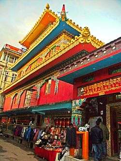
The Tibetan settlement of Dharamshala began in 1959, when the Dalai Lama had to flee Tibet and the Prime Minister of India, Jawaharlal Nehru, allowed him and his followers to settle in McLeodGanj (in Upper Dharmshala), a former colonial British summer picnic spot. "Nehru was delighted with the 'forgotten ghost-town wasting in the woods', and offered it to the Dalai Lama."[13] There they established the "government-in-exile" in 1960 and the Namgyal Monastery. Dharamshala had been connected with Hinduism and Buddhism for a long time, many monasteries having been established there in the past, by Tibetan immigrants in the 19th century.
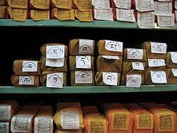
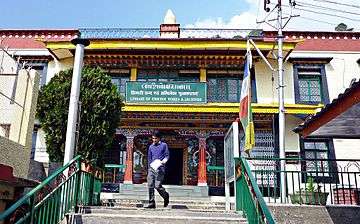
In 1970, The Dalai Lama, Tenzin Gyatso, opened the Library of Tibetan Works and Archives which houses over 80,000 manuscripts and other important resources related to Tibetan history, politics and culture. It is considered one of the most important institutions for Tibetology in the world, the new director is Geshe Lahkdor, the old translator of the Dalai Lama.
Today
Several thousand Tibetan exiles have now settled in the area; most live in and around McLeodGanj in Upper Dharamshala, where they have built monasteries, temples and schools. It has become an important tourist destination with many hotels and restaurants, leading to growth in tourism and commerce.
Dharamshala is the winter capital of Himachal Pradesh. The Legislative Assembly is at Sidhbari, near the Chinmaya Tapovan Ashram, and the winter sessions of the Government are held there. Dharamshala is also one of the famous bird watching spots in India.[14]
Transcription and pronunciation
Due to a lack of uniform observance of transliteration and transcription conventions for Hindi (and the Devanagari script in which Hindi is written), the name of the town has been transcribed into English (and other languages using Romanic scripts) variously as Dharamshala, Dharamsala and, less frequently, Dharmshala and Dharmsala.[6] These four permutations result from two variables: the transcription of the word धर्म (dharma)—particularly the second syllable (र्म)—and that of the third syllable (शा).
A strict transliteration of धर्म as written would be 'dharma' [ˈdʱərma]. In the modern spoken Hindi of the region, however, there is a common metathesis in which the vowel and consonant sounds in the second syllable of certain words (including धर्म) are transposed, which changes 'dharma' to 'dharam' (pronounced somewhere between [ˈdʱərəm] and [ˈdʱərm], depending on the speaker). Thus, if the goal of the transcription is phonetic accord with modern spoken Hindi, then 'dharam' and 'dharm' are both legitimate options.
Regarding the third syllable, the Devanagari श corresponds to the English sh sound, [ʃ]. Thus शाला is transcribed in English as 'shala'.
Therefore, the most accurate phonetic transcription of the Hindi धर्मशाला into Roman script for common (non-technical) English usage is either 'Dharamshala' or, less commonly, 'Dharmshala',[15] both of which render the sh (/ʃ/) sound of श in English as 'sh' to convey the correct native pronunciation, 'Dharamshala' [dʱərəmˈʃaːlaː] or 'Dharmshala' [dʱərmˈʃaːlaː]). Nonetheless, the alternate spelling 'Dharamsala' continues to be used in some cases despite its inaccuracy, and all four spelling permutations can be found in the English language materials of the local and state governments, in publications, and on the Internet.[16]
Regardless of spelling variations, the correct native pronunciation is with the sh sound (/ʃ/).[17] In actual practice, the spelling variant that is most common and most concordant with standards of transcription and native pronunciation is 'Dharamshala'. The official Indian English spelling is 'Dharamshala'.
Demographics
_(414208101).jpg)
As of the 2011 India census,[19] Dharamshala had a population of 30,764. Males constitute 55% of the population and females 45%. Dharamshala has an average literacy rate of 77%, higher than the national average of 74.04%: male literacy is 80% and female literacy is 73%. In Dharamshala, 9% of the population is under 6 years of age.
As of Census of India 2001:[20]
- Number of Households - 4,342
- Average Household Size (per household) - 4.0
- Population-Total - 19,124
- Population-Urban - 19,124
- Proportion of Urban Population (%) - 100
- Population-Rural - 0
- Sex Ratio - 824
- Population (0–6 years) - 1,819
- Sex Ratio (0-6 years) - 913
- SC Population - 2,611
- Sex Ratio (SC) - 861
- Proportion of SC (%) - 14.0
- ST Population - 99
- Sex Ratio (ST) - 833
- Proportion of ST (%) - 1
- Literates - 14,462
- Illiterates - 4,662
- Literacy Rate (%) - 77.0
Geography
Dharamshala has an average elevation of 1457 metres (4780 feet), covering an area of almost 8.51 km².[21]
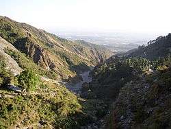
Dharamsala is located in the Kangra Valley, in the shadow of the Dhauladhar mountains.
The city is divided into two distinct sections. Kotwali Bazaar and the surrounding markets are referred to as "Lower Dharamshala" or just "Dharamshala." Further up the mountain is McLeod Ganj. A steep, narrow road connects McLeod Ganj from Dharamshala and is only accessible to taxis and small cars, while a longer road winds around the valley for use by buses and trucks. McLeod Ganj is surrounded by pine, Himalayan oak, and rhododendron.
The main crops grown in the valleys below are rice, wheat and tea.
Climate
| Climate data for Dharamsala | |||||||||||||
|---|---|---|---|---|---|---|---|---|---|---|---|---|---|
| Month | Jan | Feb | Mar | Apr | May | Jun | Jul | Aug | Sep | Oct | Nov | Dec | Year |
| Record high °C (°F) | 24.7 (76.5) |
28.0 (82.4) |
31.6 (88.9) |
35.6 (96.1) |
38.6 (101.5) |
38.6 (101.5) |
42.7 (108.9) |
37.8 (100) |
34.8 (94.6) |
34.6 (94.3) |
26.6 (79.9) |
27.2 (81) |
42.7 (108.9) |
| Average high °C (°F) | 14.5 (58.1) |
16.6 (61.9) |
21.1 (70) |
26.2 (79.2) |
30.5 (86.9) |
31.4 (88.5) |
27.2 (81) |
26.3 (79.3) |
26.3 (79.3) |
24.8 (76.6) |
20.7 (69.3) |
16.7 (62.1) |
23.5 (74.3) |
| Average low °C (°F) | 5.9 (42.6) |
7.7 (45.9) |
11.8 (53.2) |
16.3 (61.3) |
20.1 (68.2) |
21.8 (71.2) |
20.7 (69.3) |
20.2 (68.4) |
18.7 (65.7) |
15.3 (59.5) |
10.7 (51.3) |
7.4 (45.3) |
14.7 (58.5) |
| Record low °C (°F) | −1.9 (28.6) |
−1.6 (29.1) |
2.4 (36.3) |
7.3 (45.1) |
8.8 (47.8) |
12.8 (55) |
15.1 (59.2) |
14.1 (57.4) |
11.2 (52.2) |
8.0 (46.4) |
4.8 (40.6) |
−1.0 (30.2) |
−1.9 (28.6) |
| Average precipitation mm (inches) | 114.5 (4.508) |
100.7 (3.965) |
98.8 (3.89) |
48.6 (1.913) |
59.1 (2.327) |
202.7 (7.98) |
959.7 (37.783) |
909.2 (35.795) |
404.8 (15.937) |
66.3 (2.61) |
16.7 (0.657) |
54.0 (2.126) |
3,054.4 (120.252) |
| Average rainy days | 6.1 | 5.4 | 5.8 | 4.0 | 4.6 | 9.3 | 22.0 | 22.2 | 12.8 | 3.1 | 1.2 | 2.9 | 99.4 |
| Source: India Meteorological Department (record high and low up to 2010)[22][23] | |||||||||||||
Dharamshala has a monsoon-influenced, humid subtropical climate (Cwa). Summer starts in early April, peaks in early June when temperatures can reach 36 °C (97 °F), and lasts till mid-June. From July to mid-September is the monsoon season, when up to 3,000 mm (120 inches) of rainfall can be experienced, making Dharamshala one of the wettest places in the state. Autumn is mild and lasts from October to the end of November.
Autumn temperatures average around 16–17 °C (61–63 °F). Winter starts in December and continues until late February. Snow and sleet are common during the winter in upper Dharamshala (including McLeodganj, Bhagsu Nag and Naddi). Lower Dharamshala receives little frozen precipitation except hail. The snowfall of 7 January 2012 was heaviest recorded in recent times. It was caused by deep low pressure entering the Kangra district. Winter is followed by a short, pleasant spring until April. Historically, the Dhauladhar mountains used to remain snow-covered all year long; however, in recent years they have been losing their snow blanket during dry spells.
The best times to visit are the autumn and spring months.
Major suburbs
- Bhagsunag
- Cheelgari
- Triund Trekking Point
- Naddi
- Dal Lake
- Dari
- Kachehri Adda
- Khaniyara
- Kotwali Bazar
- Mant Khas
- McLeodGanj
- Upper Sakoh & Lower Sakoh
- Khel Parisar
- Sidhbari
- Sheela Chowk
- Yol
- Jama Masjid Dharamsala
- Tea Garden Cheelgari, Dharamsala
- Aganjer Mahadev Temple
- War Memorial Museum
- Ram Nagar
- Shyam Nagar
Rural areas
- Sudher
- Garoh
- Dhanotu
- Charri
- Sarah
Shopping and Entertainment in Dharamshala
The city is divided into two distinct sections. Kotwali Bazaar and the surrounding markets are referred to as "Lower Dharamshala" or just "Dharamshala" and upper Dharamshala or places such as McLeodganj, Dharamkot, etc.
In the city of Dharamshala, Maximus Mall and Gold Multiplex Cinema are open now on the National Highway Road in the Chilgari area, near Kotwali Bazaar and the main bus stand in Lower Dharamshala, in addition to the traditional shopping street called as Kotwali Bazaar. Maximus mall is sometimes considered as the biggest mall in the state. It has Cafe Coffee Day, Moti Mahal Food Chain and many reputed international brands. The Gold Multiplex Cinema offers you 3D movies in the city. Another mall The Hillside Mall is situated in the Kotwali Bazaar which serves you with delicious Dominos Pizza. The HPCA International Cricket Stadium is located near to the Govt. Degree College, Dharmashala.
Tea Gardens and Tea Tourism in Dharamshala
Dharamshala also has lush tea gardens which produce its popular Kangra tea. Traditionally known for Kangra green tea, Dharamshala now produces a variety of teas, including black, green, oolong and white teas, along with Kashmiri Kahwa and Masala Chai. Tea gardens at Mann Tea Estate are owned and operated by the Dharmsala Tea Company, which conducts guided tours of the tea gardens and factory, and offers tea tastings.[24] Kangra green tea is considered to be amongst the best in India, and has also been found to contain among the highest anti-oxidant levels of all green teas produced in India.
Transport
Road
Buses of all classes (deluxe, air-conditioned, and regular) ply daily between Dharamshala and major cities such as Chandigarh, Delhi, and Shimla through NH 154 and NH 503.
Air
Dharamshala town is reached by Kangra Gaggal Airport codes|DHM|VIGG, about 12 km to the town's south and about 10 km north of Kangra, Himachal Pradesh town. To reach Dharamshala by train, one has to reach Kangra, Himachal Pradesh town by Kangra Valley Railway line from Pathankot 94 km away or Una Himachal station i.e. 120 km from Dharamshala and then take a bus or a taxi
Rail
Pathankot is a broad gauge railway head. There is another railway line from Pathankot to Jogindernagar, a part of the Mandi District of Himachal Pradesh, which is a narrow-gauge line. The nearest station to Dharamshala on this line is Chamunda Marg, half an hour away, where a Shaktipitha is; the town is well connected by road to other parts of the country.
Dharamshala International Film Festival (DIFF)
The third edition of DIFF will showcase approximately 24 full-length feature films and documentaries, and a selection of short animation films, selected from the best of contemporary independent cinema, from 30 October to 2 November, in McLeod Ganj.
The 2014 edition of the festival will count with 12 filmmakers from India and abroad, film critics, and industry and media personnel, to attend the festival and participate in Q&A sessions. This year's festival will mark the start of the DIFF Film Fellows Programme, in which a selected number of young filmmakers from the Indian Himalayan regions will be selected to come to the festival, attend film screenings, masterclasses and workshops, and engage in one-on-one mentoring sessions with established filmmakers.
DIFF is presented by White Crane Arts & Media trust, established by filmmakers Ritu Sarin and Tenzing Sonam to promote contemporary art, cinema and independent media practices in the Himalayan region.
Educational institutions
Trekking in Dharamshala
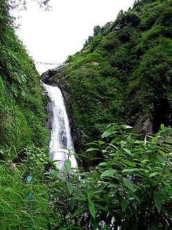
Dharamshala is a starting point to a number of trekking trails that especially includes lead trekkers across Dhauladhar into the upper Ravi Valley and Chamba district. In route, trekkers cross through forests of deodar, pine, oak and rhododendron, and pass streams and rivers and wind along vertiginous cliff tracks, and the occasional lake waterfall and glacier.
A two-kilometer amble takes one to Bhagsu, and then a further three-kilometer walk will lead the trekkers to Dharamkot. If one wishes to go on a longer walk then he/she can trek eight-kilometer to Triund. The snow line of Ilaqa Got is just a five-kilometer walk.
Other trekking trails that lead trekkers to Chamba from Dharamshala are:
- Toral Pass (4575m) which begins from Tang Narwana (1150m) that is nearly 10 km from Dharamshala
- Across Bhimghasutri Pass (4580m) via near-vertical rocky ascents, steep cliffs and dangerous gorges. This is a highly difficult level trek and takes around six days to complete.
- Dharamshala—Bleni Pass (3710m) – Dunali. Compared to other trekking trails, this one is much easier and takes around four or five-days to complete. The trek leads you through alpine pastures, woods, and streams, before ending at Dunali, on the Chamba road.
- Dharamshala is an ideal destination for rock climbing enthusiasts. One can go rock climbing over the ridges of the Dhauladhar range.
- Kareri Lake (near Kareri village) is also a famous trekking destination for travellers.
- Triund-Thatri-Trek (TTT) a very beautiful and famous circular trek for 02 nights & 03 days around Dharamshala. The first day you walk up to Triund and stay here for night and second day walk to beautiful and hidden village of Himalaya called Thatri and stay overnight at Camp Himalayan Nest. The third day after walking for couple of hours you reach to broadhead near Dharamshala.
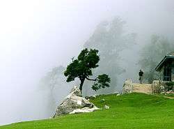
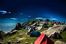 Triund Campsite is a base camp and acclimatisation point for trekkers climbing the Inderahara point in the Dhauladhar range.
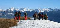 Dhauladhar ranges in the background; trekkers resting
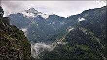 View from Trans Point, Khadota
Dharamshala International Cricket Stadium (HPCA)
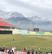
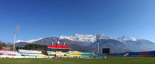
Himachal Pradesh Cricket Association Stadium (HPCAS) is a cricket stadium of international reputation, which serves as the home ground to the Himachal Pradesh state cricket team and for the IPL team Kings XI Punjab to a limited extent. By virtue of its natural backdrop, it is one of the most attractive cricket stadiums in the world. It is also one the highest altitude Cricket Stadiums in the world. In addition to Ranji matches, some international matches are held here. The first One day International held at the ground was played between India and England on Sunday, 27 January 2013 which England won by 7 wickets. In May 2011, a match between Kings XI Punjab and Chennai Superkings was held here which was attended by the Dalai Lama. [25][26][27]
The snow-capped mountains can be easily viewed throughout the year. An additional feature is the Dharamshala College nearby which is surrounded by pine trees on one side.
Notable residents
- Tenzin Gyatso, 14th Dalai Lama
- James Bruce, 8th Earl of Elgin, died here.
- Alfred W. Hallett, artist who exhibited twice in Royal Academy of Arts London and lived 41 years at Dharamkot in upper Dharamshala; died here in 1986.
- Purva Rana, Vice Queen at Miss United Continent, 2013
- Sheetal Thakur, Indian Model and Actor.
Notes and references
- 1 2 "About Us". Dharamshala Municipal Corporation. Retrieved 2 April 2016.
- ↑ FP Staff (28 August 2015). "Why only 98 cities instead of 100 announced: All questions answered about smart cities project". Firstpost.
- ↑ "Dharamshala Declared Second Capital of Himachal | Hill Post". www.hillpost.in. Retrieved 2017-01-20.
- ↑ Nagpur
- ↑ Dharma#Etymology
- 1 2 "Imperial Gazetteer2 of India, Volume 11, page 301 -- Imperial Gazetteer of India -- Digital South Asia Library". dsal.uchicago.edu.
- ↑ "Seminar on Katoch dynasty trail". Tribune India. 2009-11-04.
new findings by researchers suggest "the Katoch dynasty dates back to 8,000 years and its 300 rulers ruled in the pre-Mahabharata period and the present scion of this clan, Aditya Dev Katoch, is the 488th member of the clan in the lineage" The researchers claimed "this dynasty is not only the oldest ruling clan of India but also the oldest dynasty of the world and its founder, Adipursha, had come from Mongolia about 11,000 years back".
- ↑ Imperial Gazetteer of India (1908), Vol. II, p. 301.
- ↑ "McLEODGANJ - DHARAMSALA - LITTLE LHASA- HIMALAYAS - DALAI LAMA - DHARAMSALA INFORMATIVE AND COMMUNITY WEBSITE- TRAVEL -DHARAMSHALA- kANGRA- HIMACHAL PRADESH - INDIA". mcllo.com.
- ↑ Dharamshala The Imperial Gazetteer of India, v. 11, p. 301.
- ↑ Imperial Gazetteer of India (1908), Vol. II, pp. 301-302.
- ↑ Imperial Gazetteer of India (1908), Vol. II, p. 302.
- ↑ Craig, Mary (1999). Tears of Blood : a Cry for Tibet. Washington, D.C.: Counterpoint. p. 142. ISBN 9781582430256. OCLC 41431635.
- ↑ "Some Of The Best Bird Watching Spots In India". Petzenia Blog. 2016-12-04. Retrieved 2017-10-10.
- ↑ Devanagari_transliteration#Consonants
- ↑ See, for example, "Archived copy". Archived from the original on 20 October 2010. Retrieved 2 October 2010. , which includes both common spellings on the same page.
- ↑ See Devanagari transliteration#Consonants
- ↑ http://www.census2011.co.in/data/religion/district/230-kangra.html
- ↑ "Census of India 2001: Data from the 2001 Census, including cities, villages and towns (Provisional)". Census Commission of India. Archived from the original on 2004-06-16. Retrieved 2008-11-01.
- ↑ "Census of India Website : Office of the Registrar General & Census Commissioner, India". censusindia.gov.in.
- ↑ "Area of Dharamshala Town" (PDF). Archived from the original (PDF) on 2012-04-24.
- ↑ "Dharamsala Climatological Table Period: 1951–1980". India Meteorological Department. Archived from the original on 14 April 2015. Retrieved 10 April 2015.
- ↑ "Ever recorded Maximum and minimum temperatures up to 2010" (PDF). India Meteorological Department. Archived from the original on 21 May 2013. Retrieved 10 April 2015.
- ↑ "Our Story". Ddharmsala Tea Company. Retrieved 11 October 2018.
- ↑ http://himachal.us/2007/11/15/cricket-ground-dharamsala/3611/media/photo-news/rsood
- ↑ "HotStar Live Cricket Match Online Today, IPL 2016 Live Streaming, Sony Six Live Telecast, Sony ESPN: ICC T20 World Cup 2016 Venues". t20wclivestream2016.in. Archived from the original on 1 February 2016.
- ↑ "HotStar Live Cricket Match Online Today, IPL 2016 Live Streaming, Sony Six Live Telecast, Sony ESPN: ICC T20 World Cup 2016 Schedule". t20wclivestream.in. Archived from the original on 1 February 2016. Retrieved 13 January 2016.
- Verma, V. 1996. Gaddis of Dhauladhar: A Transhumant Tribe of the Himalayas. Indus Publishing Co., New Delhi.
- Handa, O. C. 1987. Buddhist Monasteries in Himachal Pradesh. Indus Publishing Co., New Delhi. ISBN 81-85182-03-5.
- tribuneindia.com
External links
| Wikimedia Commons has media related to Dharamsala. |
| Wikivoyage has a travel guide for Dharamsala. |
| Authority control |
|---|