Kangra, Himachal Pradesh
| Kangra City | |
|---|---|
| City | |
 Kangra City Location in Himachal Pradesh, India  Kangra City Kangra City (India) | |
| Coordinates: 32°06′N 76°16′E / 32.1°N 76.27°ECoordinates: 32°06′N 76°16′E / 32.1°N 76.27°E | |
| Country |
|
| State | Himachal Pradesh |
| District | Kangra |
| Government | |
| • Type | BJP |
| Area | |
| • Total | 15 km2 (6 sq mi) |
| Elevation | 733 m (2,405 ft) |
| Population (2011) | |
| • Total | 9,528 |
| • Rank | 17 in HP |
| • Density | 640/km2 (1,600/sq mi) |
| Languages | |
| • Official | Hindi, English |
| Time zone | UTC+5:30 (IST) |
| Vehicle registration | HP-40, HP-68, HP-04 |
Kangra is a city and a municipal council in Kangra district now in Indian state of Himachal Pradesh. Historically it was known as Nagarkot.[1]
Meaning of Kangra
Kangra is a composite word made out of Kaann (meaning ear) + gaddha (create/mold). This name was given to Kangra because of the famous ancient plastic surgeons of the region who were known to provide plastic surgery for royals who wanted to improve their looks and warriors who had lost facial features during wars.
British documentation of ancient and medieval plastic surgery
The British archaeologist and historian Sir Alexander Cunningham documented and brought to light the tradition and science of Kangra plastic operations. Although, modern plastic surgery uses the same techniques as the ancient techniques developed in South India, for north Indians Kangra's own unique methods were more popular and accessible.[2]
History
Historically known as Nagarkot[1] and "Trigarta." The town of Kangra was founded by Katoch Kshatriya Rajputs of Chandervanshi Lineage. The Katoch Rajas had a stronghold here, with a fort and rich temples.
Another ancient name of the city is Bhimagar[3] and it was supposedly founded by Raja Bhim, younger brother of Kuru Emperor Yudhishthira of Indraprastha (now Delhi).
The temple of Devi Vajreshwari was one of the oldest and wealthiest in northern India. It was destroyed, together with the fort and the town, by 1905 Kangra earthquake on 4 April 1905, when 1339 lives were lost in this place alone, and about 20,000 elsewhere. In 1855 the headquarters of the district were removed to the cantonment of Dharmsala, which was established in 1849.[1][4][5]
Invasions on Nagarkot
It is said that Mahmud of Ghazni looted a fort in the region in 1009, but whether the fort of Kangra was taken or not is not yet historically verified. There were hundreds of well-defended forts that lay between Ghazni and Nagartkot fort, and so it highly unlikely that his looting expedition ever reached Kangra. Also this claim is negated by Historians who have cited various sources to say that the fort was impregnable and remained unconquered until the conquest by Emperor Jehangir in 1622.[6]
The Katoch-Sikh battles and alliances against Kingdom of Nepal
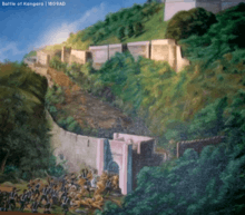
The fort was recaptured by the Katoch Kings after Jehangir's death. Multiple battles ensued between the Sikh king Maharaja Ranjit Singh and the Katoch King Sansar Chand Katoch. But, while the war between the Sikhs and Katochs was taking place, the gates of Kangra fort were left opened. The Gurkha army entered the opened gates of Nagarkot fort in 1806. This forced an alliance between the battling Sikhs and Katochs, and both the armies re-captured the fort after a battle in 1809. Kangra stayed with the Katoch Kings until 1828 when Maharaja Ranjit Singh annexed it after Sansar Chand's death. The fort and city were then captured by the British in 1846 and stayed with the British until India's independence. The princely state of Kangra was merged in India in 1948 by the then titled Raja of Kangra-Lambagraon namely Raja Druv Dev Chand Katoch. It was part of composite Punjab till November 1966 when it got transferred to Himachal Pradesh.[7]
Geography
_with_cities.png)
Kangra is located at 32°06′N 76°16′E / 32.1°N 76.27°E.[8] It has an average elevation of 733 metres (2404 ft). The district of Kangra extends from the Jalandhar Doab far into the southern ranges of the Himalaya. It is a town at the confluence of the Bener River and Majhi River, and Beas is an important river here.
Economy
Tea cultivation was introduced into Kangra valley about 1850. The Palampur fair, established by government with a view to fostering commerce with central Asia, attracts a small concourse of Yarkandi merchants. The Lahulis carry on an enterprising trade with Ladakh and countries beyond the frontier, by means of pack sheep and goats. Rice, tea, potatoes, spices, wool and honey are the chief exports.
Visitor's attractions

The Kangra Fort is also a popular tourist attraction. It is one of the oldest forts of India as well as oldest in Himachal Pradesh. Audio Guides are avialable at Maharaja Sansar Chand Museum adjoins the Kangra Fort.
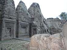
It is the home of Masroor Rock Cut Temple built by Pandavas, also known as Himalayan Pyramids and Wonder of the world for being likely contender for the UNESCO World Heritage Site.
Kangra valley is one of the most picturesque, green and luxuriant valleys of lower Himalayas sheltered by the sublime Dhauladhar range. This is one of the most important and famous districts of Himachal Pradesh due to its popularity. Kangra is mainly famous for its natural beauty and tea gardens. Number of people visit here every year.
Many ancient temples like the Jawalaji, Chamunda Devi temple, chintapurni temple, Baba Baroh and Baijnath temple are found here.
One can also pay a visit to Gopalpur Nature Park in Gopalpur village and can also see tea gardens there. Gopalpur nature park is closed on every Monday.
Mcleodganj near Dharamshala is the home-in-exile to the Dalai Lama.[9] "Bhagsunag temple" is there. Cricket ground of Dharamshala is also a major attraction because of its location and good quality pitch for players.
Demographics
As of 2001 India census,[10] Kangra had a population of 9,154. Males constitute 50% of the population and females 50%. Kangra has an average literacy rate of 83%, higher than the national average of 59.5%: male literacy is 85%, and female literacy is 81%. In Kangra, 10% of the population is under 6 years of age.
Area Profile of Kangra Town
- Number of Households - 1,924
- Average Household Size(per Household) - 5.0
- Population-Total - 10,185
- Population-Urban - 10,185
- Proportion of Urban Population (%) - 100
- Population-Rural - 0
- Sex Ratio - 997
- Population (0-6 Years) - 902
- Sex Ratio (0-6 Years) - 797
- SC Population - 660
- Sex Ratio (SC) - 1050
- Proportion of SC (%) - 7.0
- ST Population - 10
- Sex Ratio (ST) -150 0
- Proportion of ST (%) - 0
- Literates - 7,567
- Illiterates - 1,589
- Literacy Rate (%) - 92.0
Shopping Malls & Hangouts
City has many places to hangout like Hill side Mall, Maximus Mall, Domino's. For shopping Big Bazaar, Vihal Mega Mart, Rajput Shopping Complex are present.Reliance Fresh and Panatloons showrooms are also coming soon in city.
Transport
City is well connected by Kangra Airport (IATA airport code DHM) about 10 km to the City's north. City is also connected by Kangra Valley Railway line from Pathankot 94 km away. It is well connected by raod with major cities of Himachal Pradesh and India.It is just 450 km from Delhi, 36 km from Palampur and 15 km from Dharamshala, 220 km from Chandigarh
See also
References
- 1 2 3 Kangra Town The Imperial Gazetteer of India, v. 14, p. 397.
- ↑ "Archived copy". Archived from the original on 4 January 2016. Retrieved 23 August 2015. Official account of Plastic Surgery in Ancient India
- ↑ Early Aryans to Swaraj By S.R. Bakshi, page 40
- ↑ Kangra District The Imperial Gazetteer of India, v. 14, p. 380. .
- ↑ Dharamsala The Imperial Gazetteer of India, v. 11, p. 301.
- ↑ "Archived copy". Archived from the original on 1 November 2015. Retrieved 23 August 2015. Official historical account of Kangra
- ↑ "Official website". Archived from the original on 9 January 2012.
- ↑ Falling Rain Genomics, Inc - Kangra
- ↑ An Informative, Travel and Community website of Dharamsala, McleodGanj and Kangra Valley
- 1 2 "Census of India 2001: Data from the 2001 Census, including cities, villages and towns (Provisional)". Census Commission of India. Archived from the original on 2004-06-16. Retrieved 2008-11-01.
Further reading
- Chakrabarti D.K. (1984). The Antiquities of Kangra. Delhi: Munshiram Manoharlal Publishers Private Limited.
External links
| Wikiquote has quotations related to: Kangra, Himachal Pradesh |

- Kangra photo gallery
- Official Website of Kangra
- Plastic Surgery in Kangra and rest of India in ancient times
| Authority control |
|---|