Kandhamal district
| Kandhamal | |
|---|---|
| District | |
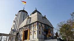 Jagannath temple in Phulbani, the headquarters of Kandhamal | |
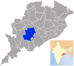 Location in Odisha, India | |
| Coordinates: 20°28′N 84°14′E / 20.47°N 84.23°ECoordinates: 20°28′N 84°14′E / 20.47°N 84.23°E | |
| Country |
|
| State | Odisha |
| Headquarters | Phulbani |
| Government | |
| • Collector & District Magistrate | Dr. Brundha D, IAS |
| • Superintendent of Police | Shri Prateek Singh, IPS |
| • MP of Kandhamal | Smt. Pratyusha Rajeshwari Devi, (BJD) |
| Area | |
| • Total | 8,021 km2 (3,097 sq mi) |
| Elevation | 700 m (2,300 ft) |
| Population (2011)[1] | |
| • Total | 731,952 |
| • Density | 91/km2 (240/sq mi) |
| Languages | |
| • Official | Odia, English |
| Time zone | UTC+5:30 (IST) |
| PIN | 762 0xx |
| Vehicle registration | OD-12 |
| Sex ratio | 0.964 ♂/♀ |
| Literacy | 65.12% |
| Lok Sabha constituency | Kandhamal |
| Vidhan Sabha constituency |
3
|
| Climate | Aw (Köppen) |
| Precipitation | 1,587 millimetres (62.5 in) |
| Avg. summer temperature | 40 °C (104 °F) |
| Avg. winter temperature | 5 °C (41 °F) |
| Website |
www |
| This article is part of a series on |
| Odisha |
|---|
 |
| Governance |
|
| Topics |
| GI Products |
|
Districts Divisions |
|
|
Kandhamal is a district of the state of Odisha, India. The district headquarters of the district is Phulbani.
History
The Kandhmal district was created on 1 January 1994 from the former Boudh-Kandhmal district as a result of district reorganization in the state of Odisha. Before that the district was known as Phulbani.
Geography
The district lies between 83.30° E to 84-48° E longitude and 19-34° N to 20-54° latitude. The district headquarters is Phulbani, located in the central part of the district. The other popular locations are Baliguda, G. Udayagiri, Tikabali and Raikia.
The territory is rural, with scenic beauty such as waterfalls and springs, and also has a number of historical antiquities.
- Area 8,021 km².
- Altitude 300 to 1100 meter
- Rainfall 1,597 millimetres (62.9 in)
- Climate Minimum temperature (December) 1 °C (34 °F); maximum temperature (May) 35 °C (95 °F)
A majority of the land area of the district (71%) is forests, and 12% of the land is cultivable. The connectivity with other districts is poor. Kandhamal is one of the poorest districts in Orissa, ranking 29th out of 30 districts by the Human Development Index.[2]
Demographics
According to the 2011 census Kandhamal district has a population of 731,952,[1] roughly equal to the nation of Guyana[3] or the US state of Alaska.[4] This gives it a ranking of 497th in India (out of a total of 640). The district has a population density of 91 inhabitants per square kilometre (240/sq mi). Its population growth rate over the decade 2001-2011 was 12.92%. Kandhamal has a sex ratio of 1037 females for every 1000 males, and a literacy rate of 65.12%.[1]
Most inhabitants belong to the Kandha (Khonds) tribes, following various religious faiths, who are said to be "proud and aggressive" in the words of a district official.[5] The Khonds hold 77% of the cultivable land.
About 17% of the population are Panas who are designated as Scheduled Castes. They hold 9% of the cultivable land. The majority of the Panas (90%) are Catholics.[6]
Frequest ethnic clashes occur between the Kandhas and the Panas and, since 2000, the ethnic clashes took on a religious communal aspect, leading to massive riots in August-September 2008.[7]
Culture
Festivals
The people of Kandhmal celebrate many religious festivals. The Danda Nach is celebrated in the district mainly by the Khond tribals still following their traditional religion. They observe this for thirteen days with sanctity. People go fasting for all the thirteen days who viewed for the particular boon or for grace. The festival starts from first April and closes on thirteenth day. The closing ceremony is called as "Meru". In the month of January, Khonds perform worship rituals after harvesting in the villages as per their own convenience. This puja is called "Sisaa Laka". In the month of March they perform puja to get blessings from the village deity (Darni Penu) and "Saaru Penu" mountain deity to collect the mohula flower and green mangoes as well as the forest products. After offering to the deity only they collect the product as their food etc. In the month of April/may the offer the mohula flower in the form of cakes to village deity, this is called "Maranga Laka". On special occasions "Kedu Laka" is done depending on the requirement of the mother earth, which is decided by the village priest Locally called "Kuta Gatanju"."Kedu Laka"is one of the main occasion among Kandha trives in Raikia block, they do Kedu Laka to eat Mangoes of the village. After the sowing of the crops, to appease the mother earth puja is performed for good crop at the village deity by the priest called "Jakera". This Puja is called "Bora Laka". This puja is done in the month of September/October. In the month of November/December new crop is collected and out of which Chuda and rice is prepared and made khiri which is offered to village deity and the villagers eat the new food. Many of the Khond tribals had converted to Protestant Christianity in the late Nineteenth Century, and they celebrate Christmas and Easter. Some of the Khond follow Islam and Eid, Ramzan and Muharram are also celebrated.
The Catholic Panas celebrate Christmas and Easter while the Hindu Panas celebrate all Hindu Festivals. There are several Panas who have converted from catholicism and Hinduism to Buddhism, especially in Raikia and Balliguda, and they celebrate Buddh Jayanti and Ambedkar Jayanti as religious Festivals.
There are other small communities like Sikhs and Jains who also celebrate their religious festivals.
Places of interest
Balaskumpa is a village in this south-east of Kandhmal (Phulbani) Sub-Division situated 20-25’N and 84-21’ at the confluence of two hill streams which combine to form Pilla Salki river. It is 15 km (9.3 mi) from Phulbani district headquarters, connected by a good road.
Belghar is situated at a height of more than 2,000 feet (609.6 metres) above the sea level in Balliguda sub-division. It is connected by a road. The place is 70 km (43 mi) from Balliguda and 155 km from Phulbani. The place is full picturesque scenery, mountains, forest and wild animals, especially elephants. It has an Inspection Bungalow of Forest Department, which is built with wooden planks. It is lighted by solar power. Ushabali valley near the village is one of the rare beauty spots in this hilly region. Some times flocks of peacocks are seen by the roadside and haunted by wild elephants.
Chakapad is situated about 800 ft (243.84 m) from sea level in G. Udayagiri Tahasil. The historical river Bhrutanga originates here.
Another temple dedicated to Lord Anandeswar and Jogeswar (Siva) is located near by one big fairies held here on the Sivaratri day. The place is situated in the midst of thick forest, abounds in beautiful natural scenery.
Daringbadi is situated at a height of about 3,000 ft (914.4 m) above sea level in Balliguda sub-division. It is 105 km (65 mi) from Phulbani. The place can be approached directly from Berhampur. The place is attractive in summer season due to its low temperature. Hill View point has been developed at Daringbadi where from a visitor could watch and enjoy the beauty of valley. Tourist complex has been built at Daringibadi for accommodation of the tourists. Vast patch of Coffee plantation attract a large number of visitors to Daringibadi all through the year.
Dungi is about 45 km from Phulbani situated on Phulbani-Berhampur road in G. Udayagiri Tehsil. This is the only archaeological site in Kandhmal district. There was one Buddha Vihar of the 11th century, after it is ruined, Siva temples have come up on the site, excavated during construction of new temples and are kept in the temple premises. One Buddha statue has been shifted to the Odisha State Museum, Bhubaneswar from the nearby area.
Jalespeta is a beautiful valley about 127 km from Phulbani situated near Tumudibandh.
Kalinga valley is located 48 km away from Phulbani, the district headquarters on Phulbani – Berhampur road. The valley is near to Dashpalla. The valley is famous for silviculture garden and medicinal plant cultivation. The silviculture garden has rubber trees and human thick bamboo plants. The garden has pleasant aroma, which refreshes body and mind.
Ludu is located about 100 km (62 mi) from Balliguda in Kotagarh Block and 185 km from Phulbani. It is situated in dense forest inhabited by wild elephants. One fair weather road is leading to the side via Subarngiri. There is a waterfall 100’ (30.5m) high.
Mandasaru Kuti is about 100 km from Phulbani in Raikia Block. There is an old church on the outskirts of the village, surrounded by mountains. Nearby is a mountain gorge.
Pakadajhar is about 30 km from Phulbani town near the village Sudrukumpa situated on Phulbani-Boudh road in Phulbani Tahasil. There is one waterfall of 60’ height in natural forest background. One good road is leading to the site from Sudrukumpa. With recent development of the destinations a lot of tourists haunt the place for picnic from early November to end of February.
Putudi is 18 km from Phulbani town with a waterfall of 100 feet (30 m) height, situated in dense forest. The roaring sound of water fall with dense forest all around creates a thrilling sensation to the mind of visitors. One good road is leading to the side. The waterfall is on the river Salunki and excellent shooting spot.
Rushimal is situated about 50 km from Daringibadi near the village Tamangi in Hattimunda G. P. A group of hills known as Rushimal hills from which originates river Rushikulya. At the source there is a small reservoir known as “Rushikunda” and above the hill top a cave known as “Rushigumpha”. The place is famous for Baruniyatra.
Urmagada is 17 km from Phulbani town on Phulbani-Gochhapada road in Phulbani Tahasil. The waterfall is of 50’ height, situated in a dense forest. One fair-weather road is leading to the site.may not pai
Transport
The nearest airport is at Bhubaneswar 211 km (131 mi). There is an airstrip at Gudari 5 km from Phulbani town for landing small planes and helicopters.
The nearest railway station is Rairakhol, on the Sambalpur – Bhubaneshwar line, which is 99 km from Phulbani. However Berhampur 165 km (103 mi) away from Phulbani is another convenient rail link. One could conveniently make Phulbani the district headquarters/ Balliguda, the sub-divisional headquarters as the base for visiting the places of interest.
By road, Kandhamal can approached from Sambalpur via Baudh (170 km, 106 miles) and Berhampur (165 km) as well as from Bhubaneshwar via Nayagarh (210 km, 130 miles). It is 170 km (110 mi) away from Bolangir.
While there are no dedicated tourist buses to the places of interest in the district, taxis may be hired at Phulbani or Balliguda. There is no Railway route.
Health facilities
There are fourteen hospitals:
- District Headquarters Hospital, Phulbani
- Sub Divisional Hospital, Balliguda
- Community Health Centre, Subarnagiri
- Community Health Centre, Tumudibandha
- Community Health Centre, Barakhama
- Community Health Centre, Daringbadi
- Community Health Centre, K.Nuagaon
- Community Health Centre, Raikia
- Community Health Centre, G.Udayagiri
- Community Health Centre, Brahamanpad
- Community Health Centre, Tikabali
- Community Health Centre, Gumagarh
- Community Health Centre, Phiringia
- Community Health Centre, Khajuripada
Politics
Vidhan sabha constituencies
The following is the 3 Vidhan sabha constituencies[8][9] of Kandhamal district and the elected members[10] of that area
| No. | Constituency | Reservation | Extent of the Assembly Constituency (Blocks) | Member of 14th Assembly | Party |
|---|---|---|---|---|---|
| 82 | Baliguda | ST | Baliguda, K. Nuagam, Kotagarh, Tumudibandh | Sri Rajeeb Patra | BJD |
| 83 | G. Udayagiri | ST | Raikia, Daringbadi, G. Udayatiri, Tikabali, G. Udayatiri (NAC) | Jacob Pradhan | INC |
| 84 | Phulbani | ST | Chakapada, Phulbani, Khajuripada, Phiringia, Phulbani (NAC) | Dugni Kanhar | BJD |
Communal unrest and insurgency
On 25 December 2007, ethnic conflict broke out between Khond tribals and Pana Scheduled Caste people.
On 23 August 2008, Swami Lakshmanananda Saraswati - a leader of the Vishwa Hindu Parishad - was murdered by Maoist gunmen along with four others, including a boy. Maoist rebels took responsibility for the multiple murders. [11] This led to large scale riots between the indigenous ethnic Kandha tribe tribals and the Scheduled Caste Pana communities. The underlying causes are complex and cross political, religious boundaries.[5] Land encroachment perceived or otherwise being a particular source of tension between the communities, the clash was predominantly ethnic, but assumed communal overtones despite the fact that in addition to Hindu Khonds, even Protestant Christian Khonds were fighting against the Catholic Panas. In April 2010, a special "fast track" court in Phulbani convicted 105 people.[12] Ten people were acquitted due to lack of evidence.
It is currently a part of the Red Corridor of India, an area with significant Maoist insurgency activity.[13] Suspected Maoist rebels detonated a roadside land mine on 27 November 2010, blowing up an ambulance. A patient, a paramedic, and the vehicle's driver were killed.[14]
References
- 1 2 3 "District Census 2011". Census2011.co.in. 2011. Retrieved 2011-09-30.
- ↑ Uma & Grover 2010, p. 14.
- ↑
US Directorate of Intelligence. "Country Comparison:Population". Retrieved 2011-10-01.
Guyana 744,768
- ↑
"2010 Resident Population Data". U. S. Census Bureau. Archived from the original on 2011-08-23. Retrieved 2011-09-30.
Alaska 710,231
- 1 2 "India's remote faith battleground". BBC News. 26 September 2008.
- ↑ Uma & Grover 2010, p. 14-15.
- ↑ Uma & Grover 2010, pp. 16-17.
- ↑ Assembly Constituencies and their EXtent
- ↑ Seats of Odisha
- ↑ "List of Member in Fourteenth Assembly". ws.ori.nic.in. Archived from the original on 2 May 2007. Retrieved 19 February 2013.
MEMBER NAME
- ↑ "'Majority of Maoist supporters in Orissa are Christians'". The Hindu. PTI. Archived from The Hindu the original Check
|url=value (help) on 2008-10-08. - ↑ Sib Kumar Das (1 April 2010). "7 sentenced in Kandhamal riots cases". The Hindu. Chennai, India.
- ↑ "83 districts under the Security Related Expenditure Scheme". IntelliBriefs. 2009-12-11. Retrieved 2011-09-17.
- ↑ "Report: Suspected rebels kill 3 in eastern India". The Guardian. London. 28 November 2010.
- Sources
- Osuri, Goldie (2013), Religious Freedom in India: Sovereignty and (anti) Conversion, Routledge, ISBN 0415665574
- Uma, Saumya; Grover, Vrinda (2010), Kandhamal: The Law must Change its Course, New Delhi: MARG: Multiple Action Research Group, ISBN 978-81-87377-19-1
External links
- Official website
- Preliminary Findings & Recommendations - The National People’s Tribunal on Kandhamal, available at South Asia Citizens Web, 29 August 2010.
- From Kandhamal to Karavali: The Ugly Face of the Sangh Parivar, available at South Asia Citizen's Web, March 2009.
Places adjacent to Kandhamal district | |
|---|---|
| Governance |
|  | |||||
|---|---|---|---|---|---|---|---|
| Topics | |||||||
| GI Products | |||||||
| Districts and divisions |
| ||||||
| Cities | |||||||