Kanauga, Ohio
| Kanauga, Ohio | |
|---|---|
| Census-designated place | |
 Kanauga  Kanauga | |
| Coordinates: 38°50′32″N 82°8′49″W / 38.84222°N 82.14694°WCoordinates: 38°50′32″N 82°8′49″W / 38.84222°N 82.14694°W | |
| Country | United States |
| State | Ohio |
| County | Gallia |
| Townships | Gallipolis, Addison |
| Area | |
| • Total | 0.32 sq mi (0.83 km2) |
| • Land | 0.29 sq mi (0.75 km2) |
| • Water | 0.03 sq mi (0.08 km2) |
| Elevation[1] | 570 ft (170 m) |
| Population (2010) | |
| • Total | 175 |
| • Density | 605/sq mi (233.4/km2) |
| Time zone | UTC-5 (Eastern (EST)) |
| • Summer (DST) | UTC-4 (EDT) |
| FIPS code | 39-39564[2] |
| GNIS feature ID | 1076164[3] |
Kanauga is an unincorporated community and census-designated place (CDP) in Gallia County, Ohio, United States. As of the 2010 census it had a population of 175.[2]
History
A post office called Kanauga was established in 1896, and remained in operation until it was discontinued in the 1960s.[4] The origin of the name Kanauga is obscure.[5]
Geography
Kanauga is located in eastern Gallia County, primarily in the northeast corner of Gallipolis Township, but extending north into the southeast corner of Addison Township. It is bordered to the south by the city of Gallipolis and to the east by the Ohio River, which forms the Ohio–West Virginia border. Directly across the river is the city of Point Pleasant, West Virginia, and the mouth of the Kanawha River.
U.S. Route 35 passes through the southern part of the Kanauga CDP, leading east across the Ohio on the Silver Memorial Bridge. US-35 leads southeast 37 miles (60 km) to its terminus in Teays Valley, West Virginia, and northwest 62 miles (100 km) to Chillicothe. Ohio Route 7 passes through the center of Kanauga, leading northeast 52 miles (84 km) to Parkersburg, West Virginia, and southwest 4 miles (6 km) to the center of Gallipolis. Huntington, West Virginia, is 43 miles (69 km) to the southwest via Route 7.
According to the U.S. Census Bureau, the Kanauga CDP has a total area of 0.32 square miles (0.83 km2), of which 0.29 square miles (0.75 km2) is land and 0.03 square miles (0.08 km2), or 9.76%, is water, consisting of the western side of the Ohio River.
References
- ↑ "US Board on Geographic Names". United States Geological Survey. 2007-10-25. Retrieved 2008-01-31.
- 1 2 "Geographic Identifiers: 2010 Demographic Profile Data (G001): Kanauga CDP, Ohio". American Factfinder. U.S. Census Bureau. Retrieved January 12, 2017.
- ↑ U.S. Geological Survey Geographic Names Information System: Kanauga, Ohio
- ↑ U.S. Geological Survey Geographic Names Information System: Kanauga Post Office (historical)
- ↑ Overman, William Daniel (1958). Ohio Town Names. Akron, OH: Atlantic Press. p. 67.
Municipalities and communities of Gallia County, Ohio, United States | ||
|---|---|---|
| Villages | 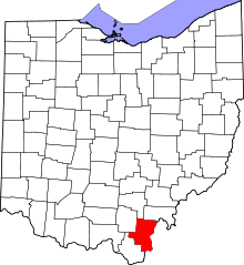 | |
| Townships | ||
| CDP | ||
| Unincorporated communities | ||