Jianye District
| Jianye 建邺区 | |||||||||||||||||||||||||||||||||
|---|---|---|---|---|---|---|---|---|---|---|---|---|---|---|---|---|---|---|---|---|---|---|---|---|---|---|---|---|---|---|---|---|---|
| District | |||||||||||||||||||||||||||||||||
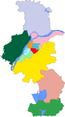
 Jianye Location in Jiangsu | |||||||||||||||||||||||||||||||||
| Coordinates: 32°01′28″N 118°42′39″E / 32.0244°N 118.7109°ECoordinates: 32°01′28″N 118°42′39″E / 32.0244°N 118.7109°E | |||||||||||||||||||||||||||||||||
| Country | People's Republic of China | ||||||||||||||||||||||||||||||||
| Province | Jiangsu | ||||||||||||||||||||||||||||||||
| Sub-provincial city | Nanjing | ||||||||||||||||||||||||||||||||
| Area | |||||||||||||||||||||||||||||||||
| • Total | 82 km2 (32 sq mi) | ||||||||||||||||||||||||||||||||
| Population (2002) | |||||||||||||||||||||||||||||||||
| • Total | 160,000 | ||||||||||||||||||||||||||||||||
| • Density | 2,000/km2 (5,100/sq mi) | ||||||||||||||||||||||||||||||||
| Time zone | UTC+8 (China Standard) | ||||||||||||||||||||||||||||||||
| Postal code | 210008 | ||||||||||||||||||||||||||||||||
| Area code(s) | 025 | ||||||||||||||||||||||||||||||||
| Nanjing district map |
| ||||||||||||||||||||||||||||||||
| Website |
njjy | ||||||||||||||||||||||||||||||||
Jianye District (simplified Chinese: 建邺区; traditional Chinese: 建鄴區; pinyin: Jiànyè Qū) is one of 11 districts of Nanjing, the capital of Jiangsu province, China.[1]
History
Nanjing, once called Jianye, was the capital city of six dynasties beginning in 3 AD, in large part because of its position on the Yangtze River.[2]
Administrative subdivisions
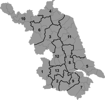
Jianye has administrative jurisdiction over the following 6 subdistricts:
| Name | Chinese (S) | Hanyu Pinyin | Population (2010)[3] | Area (km2) |
|---|---|---|---|---|
| Mochouhu Subdistrict | 莫愁湖街道 | Mòchóuhú Jiēdào | 125,765 | 2.4 |
| Shazhou Subdistrict | 沙洲街道 | Shāzhōu Jiēdào | 56,474 | 11.7 |
| Shuangzha Subdistrict | 双闸街道 | Shuāngzhá Jiēdào | 19,560 | 17 |
| Jiangxinzhou Subdistrict | 江心洲街道 | Jiāngxīnzhōu Jiēdào | 20,865 | 14.3 |
| Xinglong Subdistrict | 兴隆街道 | Xīnglóng Jiēdào | 67,274 | 8.21 |
| Nanyuan Subdistrict | 南苑街道 | Nányuàn Jiēdào | 110,596 | 3.2 |
- Defunct - Binhu Subdistrict (滨湖街道) & Nanhu Subdistrict (南湖街道) both subdistricts merged with Mochu Subdistrict that formerly part of Gulou to form Mochouhu Subdistrict under Jianye.
The Jianye district is responsible for the administration of the following urban areas:[4]
| Direction | Place | Image | Comments |
|---|---|---|---|
| North | Mochouhu Subdistrict / Binhu Subdistrict (莫愁湖街道) / (滨湖街道) | 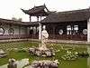 | Northeast area, near and including Mochou Lake[5] |
| Nanyuan Subdistrict (南苑街道) | South of the Mochou Lake area.[6] | ||
| Shazhou Subdistrict (沙洲街道) | 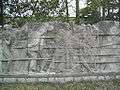 | West of the Mochou Lake area.[7] Including the Nanjing Massacre Memorial Wall. | |
| Center | Hexi (河西中央商务区) | 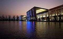 | Includes the Nanjing International Expo Center |
| Conference and Tourism Center (江东商业文化旅游中心区) | West of the Nanjing Olympic Sports Center and including the Jinling Riverside Conference Hotel[8] | ||
| Xinglong Subdistrict (兴隆街道) | 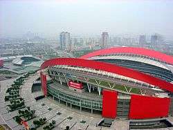 | Also known as Booming Subdistrict. In the area of the Nanjing Olympic Sports Center.[9] The arena has the capacity for 60,000 people[10] | |
| West | Jiangxin Island (江心洲街道) |  | Also known as Jiangxinzhou and the New Nanjing Eco-Technology Island |
| East | Jianye Metro Technology Park (建邺区新城科技园) | East and southeast of the Nanjing Olympic Sports Center.[11] | |
| South | Shuangzha Subdistrict (双闸街道) | In the southern area of the district.[12] |
Transportation
Rail service is available at the Yuantong Station between Line 1 and Line 2[13] Line 1 service at Olympic Stadium Station, and Line 2 service at Olympic Stadium East Station, Mochouhu Station, Jiqingmendajie Station, Xinglongdajie Station, Yurundajie Station, and Youfangqiao Station of the Nanjing Metro.[14]
Jiangxin Island may be reached via the Yingtian Street Elevated Bridge,[15] which is a 760 metres (2,490 ft) bridges that connects the island, and its YOG Forest Park, to the mainland at the Nanjing International Expo Center, one of the sites for the 2014 Summer Youth Olympics. It is the first pedestrian bridge to cross the Yangtze.[16]
See also
- Education
References
- ↑ Brian Roberts; Trevor Kanaley. Urbanization and Sustainability in Asia: Case Studies of Good Practice. Asian Development Bank; 2006. ISBN 978-971-561-607-2. p. 119.
- ↑ Rita Yi Man Li, "A Study on the Impact of Culture, Economic, History and Legal Systems Which Affect the Provisions of Fittings by Residential Developers in Boston, Hong Kong and Nanjing," Global Business and Management Research: An International Journal. 1:3-4. 2009. Access via Questia, an online subscription service.
- ↑ shi, Guo wu yuan ren kou pu cha ban gong; council, Guo jia tong ji ju ren kou he jiu ye tong ji si bian = Tabulation on the 2010 population census of the people's republic of China by township / compiled by Population census office under the state; population, Department of; statistics, employment statistics national bureau of (2012). Zhongguo 2010 nian ren kou pu cha fen xiang, zhen, jie dao zi liao (Di 1 ban. ed.). Beijing Shi: Zhongguo tong ji chu ban she. ISBN 978-7-5037-6660-2.
- ↑ Jianye District (建邺区). National Bureau of Statistics of the People's Republic of China. Retrieved May 13, 2014.
- ↑ Map of Binhu Subdistrict (search on: 滨湖街道, 南京). map.baidu.com Retrieved May 12, 2014.
- ↑ Nanyuan Subdistrict, Nanjing. Google maps. Retrieved May 13, 2014.
- ↑ Map of Shazhou Subdistrict (search on: 沙洲街道, 南京). map.baidu.com Retrieved May 12, 2014.
- ↑ Conference and Tourism Center. Google maps. Retrieved May 13, 2014.
- ↑ Xinglong Subdistrict, Nanjing. Google maps. Retrieved May 13, 2014.
- ↑ Kenneth Pletcher. The Geography of China: Sacred and Historic Places. The Rosen Publishing Group; 2011. ISBN 978-1-61530-134-8. p. 201.
- ↑ Jianye Metro Technology Park (建邺区新城科技园), Nanjing. Google maps. Retrieved May 13, 2014.
- ↑ Shuangzha Subdistrict, Nanjing. Google maps. Retrieved May 13, 2014.
- ↑ 南京地铁一号线. Nju.gov.cn (2008-11-12). Retrieved May 13, 2014.
- ↑ "二号线一日游". Archived from the original on December 21, 2013. Retrieved May 13, 2014.
- ↑ Yingtian Street Elevated Bridge. Google Maps. Retrieved May 12, 2014.
- ↑ "1st pedestrian bridge over Yangtze River taking shape in Nanjing". JS China. January 14, 2014. Retrieved May 12, 2014.
External links
- Jianye District Government official website (in Chinese)