Tongshan District
| Tongshan 铜山区 | |
|---|---|
| District | |
 Location in Xuzhou | |
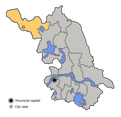 Xuzhou in Jiangsu | |
| Coordinates: 34°18′28″N 117°15′24″E / 34.3077°N 117.2568°ECoordinates: 34°18′28″N 117°15′24″E / 34.3077°N 117.2568°E | |
| Country | People's Republic of China |
| Province | Jiangsu |
| Prefecture-level city | Xuzhou |
| Area | |
| • Total | 2,088 km2 (806 sq mi) |
| Elevation | 35 m (115 ft) |
| Population (2009) | |
| • Total | 124,000 |
| • Density | 59/km2 (150/sq mi) |
| Time zone | UTC+8 (China Standard) |
| Website |
www |
Tongshan District (simplified Chinese: 铜山区; traditional Chinese: 銅山區; pinyin: Tóngshān Qū; literally: "bronze mountain"), formerly Tongshan County (铜山县; 銅山縣; Tóngshān Xiàn) is one of six districts of Xuzhou, Jiangsu province, People's Republic of China, bordering Anhui and Shandong provinces.
History
Tongshan was originally knows as Pengcheng County, the latter merged into Xuzhou during the Yuan and the Ming dynasties, also in the early Qing. In 1733, as Xuzhou became a prefecture (fu) from an independent department (zhili zhou), its department proper was separated and renamed "Tongshan" (literally: copper-filled hill), which derives from an island in the Weishan Lake.[1]
Tongshan was once the metropolitan county (shou xian) of Xuzhou, thus it referred to the prefecture since 1912, until the Japanese Army captured the county and made its urban area to be Xuzhou City in 1939.[2]
The county was dissolved in 1952, but restored in the next year.[1] It became a district since 2010.
References
- www.xzqh.org (in Chinese)