Pei County
| Pei County 沛县 | |
|---|---|
| County | |
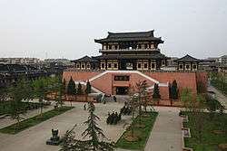 Gefeng Altar (歌风台) | |
 Location in Xuzhou | |
 Peixian Location in Jiangsu | |
| Coordinates: 34°42′58″N 116°55′08″E / 34.716°N 116.919°ECoordinates: 34°42′58″N 116°55′08″E / 34.716°N 116.919°E | |
| Country | People's Republic of China |
| Province | Jiangsu |
| Prefecture-level city | Xuzhou |
| Area | |
| • Total | 1,576 km2 (608 sq mi) |
| Population (2010) | |
| • Total | 1,141,935 |
| • Density | 720/km2 (1,900/sq mi) |
| Time zone | UTC+8 (China Standard) |
| Postal code | 221600 |
| Area code(s) | 0516 |
| Website |
www |
Pei County, or Peixian (simplified Chinese: 沛县; traditional Chinese: 沛縣; pinyin: Pèi Xiàn), is under the administration of Xuzhou, Jiangsu province, China, bordering the Shandong prefecture-level cities of Jining to the northwest and Zaozhuang to the northeast and sitting on the western shore of Nansi Lake. It has an area of 1,576 square kilometres (608 sq mi) and a population of 1,141,935 in 2010.[1]
History
Pei County is the hometown of Liu Bang (Emperor Gao), the founding emperor of the Han dynasty.
Xiaopei (小沛) is an ancient Chinese town located in present-day Pei County. In the late Eastern Han dynasty, it was under the jurisdiction of Xu Province, which was governed by Tao Qian. Before Tao Qian died, he handed his governorship over to Liu Bei. Liu Bei took refuge in Xiaopei when Lü Bu seized Xu Province from him through deceit.
References
- ↑ 徐州市2010年第六次全国人口普查主要数据公报 (in Chinese). Official website of Chinese Government. Archived from the original on June 6, 2012. Retrieved December 10, 2011.
External links
- Official website of Pei County government
- www.xzqh.org (in Chinese)