Xuyi County
| Xuyi County 盱眙县 | |
|---|---|
| County | |
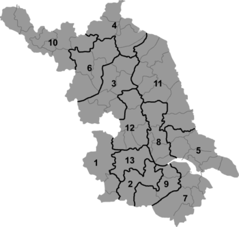 Xuyi Location in Jiangsu | |
| Coordinates: 32°58′48″N 118°33′36″E / 32.980°N 118.560°ECoordinates: 32°58′48″N 118°33′36″E / 32.980°N 118.560°E[1] | |
| Country | People's Republic of China |
| Province | Jiangsu |
| Prefecture-level city | Huai'an |
| Time zone | UTC+8 (China Standard) |
| Website | http://www.xuyi.gov.cn/ |
Xuyi County (simplified Chinese: 盱眙县; traditional Chinese: 盱眙縣; pinyin: Xūyí Xiàn) is under the administration of Huai'an, Jiangsu province, China. The southernmost of Huai'an's county-level divisions, it borders the prefecture-level cities of Suqian to the north and Chuzhou (Anhui) to the south and west. Xuyi is noted for production of crayfish.
Etymology
The meaning of Xuyi is debatable, and there are two major accounts. For one: sited on the top of a hill, the ancient city afforded a extensive view of the vicinity. In the ancient Chinese, "xu" means have one's eyes opened wide, while "yu" means look straight ahead.[2] Thus, it was named after Xuyi, the posture of looking out.[3] For another, it was named after Xuyi, a eastern hill outside the city.[4]
History
When the ancient city of Sizhou whelmed in the Hongze Lake, its seat was transferred to the county in 1680.
For the sake of managing the Hongze Lake, Xuyi was annexed to Jiangsu in 1955, along with Sihong.[5]
Historical sites
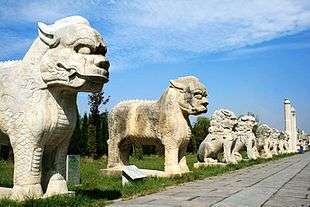
A famous local site are the ruins of the Ming Ancestors' Mausoleum (明祖陵; Míngzǔlíng), built by the first Ming emperor Zhu Yuanzhang in honor of his ancestors who lived here.
The mausoleum site was flooded ca. 1680, when the Yellow River changed its course, merged with the Huai River, and the Hongze Lake appeared. (The nearby Ming-era city of Sizhou (泗州) was completely flooded by the same lake as well). In the 1960s, the lake waters receded; the stone figures of the mausoleum's Spirit way were subsequently recovered from the mud and re-erected. (33°5′7″N 118°28′18″E / 33.08528°N 118.47167°E)[6]
External links
- Xuyi County English guide (Jiangsu.NET)
Notes
- ↑ Google (2014-07-02). "Xuyi" (Map). Google Maps. Google. Retrieved 2014-07-02.
- ↑ 說文解字 Shuowen jiezi[Explanation of Single Component Graphs and Analysis of Composite Characters], vol.4: "盱:張目也...眙:直視也".
- ↑ 讀史方輿紀要[Essentials of Geography for Reading History], vol.21: "盱眙者,城居山上,可以矚遠也".
- ↑ Draft History of Qing, vol.59: "東:盱眙山,縣以此名".
- ↑ 江苏省志·水利志 [Gazetteers of Jiangsu: Water Resources Gazetteer]. 2001. pp. 700–761. ISBN 7-80643-555-7.
- ↑ Eric N. Danielson, "The Ming Ancestor Tomb". China Heritage Quarterly, No. 16, December 2008.