Jiang'an District
| Jiang'an 江岸区 | ||||||||||||||||||||||||||||||||||||
|---|---|---|---|---|---|---|---|---|---|---|---|---|---|---|---|---|---|---|---|---|---|---|---|---|---|---|---|---|---|---|---|---|---|---|---|---|
| District | ||||||||||||||||||||||||||||||||||||
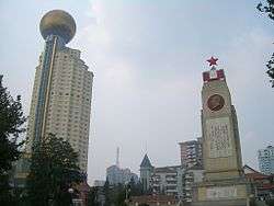 02.16 Flood Memorial in Riverside Park (沿江公园) | ||||||||||||||||||||||||||||||||||||
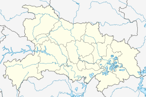 Jiang'an Location in Hubei | ||||||||||||||||||||||||||||||||||||
| Coordinates: 30°38′11″N 114°19′49″E / 30.6365°N 114.3304°ECoordinates: 30°38′11″N 114°19′49″E / 30.6365°N 114.3304°E[1] | ||||||||||||||||||||||||||||||||||||
| Country | People's Republic of China | |||||||||||||||||||||||||||||||||||
| Province | Hubei | |||||||||||||||||||||||||||||||||||
| Sub-provincial city | Wuhan | |||||||||||||||||||||||||||||||||||
| Area[2] | ||||||||||||||||||||||||||||||||||||
| • Total | 64.24 km2 (24.80 sq mi) | |||||||||||||||||||||||||||||||||||
| Population (2010)[3] | ||||||||||||||||||||||||||||||||||||
| • Total | 895,635 | |||||||||||||||||||||||||||||||||||
| • Density | 13,942/km2 (36,110/sq mi) | |||||||||||||||||||||||||||||||||||
| Time zone | UTC+8 (China Standard) | |||||||||||||||||||||||||||||||||||
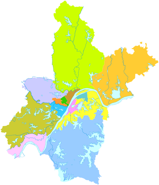
| Wuhan district map |
| |||||||||||||||||||||||||||||||||||
| Website |
www | |||||||||||||||||||||||||||||||||||
Jiang'an District (simplified Chinese: 江岸区; traditional Chinese: 江岸區; pinyin: Jiāng'àn Qū; literally: "river bank") forms part of the urban core of and is one of 13 districts of Wuhan, the capital of Hubei province, People's Republic of China.
Jiang'an Lim district is located on the Yangtze's left (northwestern) shore, and includes the northeastern half of the former Hankou city (northeast, i.e. downstream, of Jianghan Rd.). On the left bank of the Yangtze, it borders Huangpi to the north, Jianghan to the southwest, and Dongxihu to the west; on the opposite bank it borders Hongshan, Wuchang, and Qingshan.
Geography
Administrative divisions
Jiang'an District administers:[4][5]
| # | Name | Chinese (S) | ||||
|---|---|---|---|---|---|---|
| Subdistricts | ||||||
| 1 | Dazhi Subdistrict Great Wisdom | 大智街道 | ||||
| 2 | Yiyuan Subdistrict | 一元街道 | ||||
| 3 | Chezhan Subdistrict | 车站街道 | ||||
| 4 | Siwei Subdistrict | 四唯街道 | ||||
| 5 | Yongqing Subdistrict | 永清街道 | ||||
| 6 | Qiuchang Subdistrict | 球场街道 | ||||
| 7 | Xima Subdistrict | 西马街道 | ||||
| 8 | Taibei Subdistrict | 台北街道 | ||||
| 9 | Laodong Subdistrict | 劳动街道 | ||||
| 10 | Huaqiao Subdistrict | 花桥街道 | ||||
| 11 | Erqi Subdistrict | 二七街道 | ||||
| 12 | Xincun Subdistrict | 新村街道 | ||||
| 13 | Danshuichi Subdistrict | 丹水池街道 | ||||
| 14 | Shenjiaji Subdistrict[6][7] Shen Family Rock | 谌家矶街道 | ||||
| Other Areas | ||||||
| 15 | Houhu Office | 后湖街办事处 | ||||
| 16 | Tazihu Office | 塔子湖街办事处 | ||||
References
- ↑ Google (2014-07-02). "Jiang'an" (Map). Google Maps. Google. Retrieved 2014-07-02.
- ↑ "Wuhan Statistical Yearbook 2010" (PDF). Wuhan Statistics Bureau. p. 15. Archived from the original (PDF) on November 5, 2011. Retrieved 2011-06-11.
- ↑ "武汉市2010年第六次全国人口普查主要数据公报" (in Chinese). Wuhan Statistics Bureau. 2011-05-11. Archived from the original on 2011-10-25. Retrieved 2011-06-11.
- ↑ "江岸区政府门户网站" (in Simplified Chinese). 武汉市江岸区人民政府 江岸区大数据中心承办. Retrieved 25 December 2017.
街道专栏 大智街道办事处 一元街道办事处 车站街道办事处 四唯街道办事处 永清街道办事处 球场街道办事处 西马街道办事处 台北街道办事处 劳动街道办事处 花桥街道办事处 二七街道办事处 新村街道办事处 丹水池街道办事处 谌家矶街道办事处 后湖街办事处 塔子湖街办事处
- ↑ "江岸区历史沿革 (translation: The Historical Development of Jiang'an District)" (in Simplified Chinese). 行政区划网站 (translation: Administrative Divisions Website). Retrieved 25 December 2017.
2010年第六次人口普查,江岸区常住总人口895957人,其中:上海街道25425人,大智街道35087人,一元街道24827人,车站街道25069人,四唯街道32234人,永清街道18545人,西马街道61595人,球场街道26139人,劳动街道71910人,二七街道81312人,新村街道68916人,丹水池街道57768人,台北街道38531人,花桥街道131229人,谌家矶街道16197人,后湖街道137279人,百步亭花园43894人。2011年,撤销上海街道,将其管辖区域并入一元街道,办事处驻地为岳飞街7号;以武汉大道(金桥大道段)为界,在原后湖街道辖区内设立塔子湖和后湖两个街道,办事处驻地分别为兴业路145号、金桥大道24号。(武民政[2011]117号)2011年末,全区总面积64.24平方千米,户籍总人口683528人,其中农业人口1635人。辖16个街道,147个社区、14个行政村。(武汉年鉴2012数据)
- ↑ "谌(諶) Shèn 名 姓。另见162页 chén。")現代漢語詞典(第七版). Contemporary Chinese Dictionary (Seventh Edition). 商務印書舘. The Commercial Press. 1 September 2016. p. 1165. ISBN 978-7-100-12450-8.
- ↑ "百度地图" (in Simplified Chinese). 百度地图.Baidu Maps. Retrieved 25 December 2017.
谌家矶路 (E)东 Shenjiaji Rd . 西(W)
External links
- (in Chinese) Jiangnan District official site
This article is issued from
Wikipedia.
The text is licensed under Creative Commons - Attribution - Sharealike.
Additional terms may apply for the media files.