Jalan M.H. Thamrin
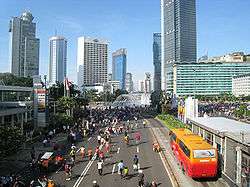 Thamrin Road during Jakarta Car Free Day. | |
| Other name(s) | Jalan Thamrin |
|---|---|
| Former name(s) | Djalan M.H. Thamrin |
| Owner | Pemprov DKI Jakarta |
| Maintained by | Dinas Pekerjaan Umum DKI Jakarta |
| Length | 2.4 km (1.5 mi) |
| Location | Central Jakarta |
| South end | The bridge of West Flood Canal |
| Major junctions | Jl. Budi Kemuliaan-Jl. Medan Merdeka Selatan, Jl. Kebon Sirih, Jl. KH. Wahid Hasyim, Bundaran HI roundabout |
| North end | Bank Indonesia roundabout |
| Construction | |
| Construction start | 1949[1] |
| Completion | 1953 |
| Inauguration | January 1951[1] |
Jalan M.H. Thamrin or Jalan Thamrin (M.H. Thamrin Road or Thamrin Road) is a major thoroughfare in Jakarta. The road is located at the center of Jakarta, running from Bundaran HI at the south end to the roundabout near Arjuna Wijaya Statue at the north end. Developed in the 1950s, the road was a landmark of post-colonial Indonesia and continue to have a prominent importance in Jakarta.
Description
Thamrin Road is classified as a secondary arterial road in Jakarta.
The road passes through five urban administrative villages:
- Gambir, Gambir, Central Jakarta
- Kebon Sirih, Menteng, Central Jakarta
- Gondangdia, Menteng, Central Jakarta
- Menteng, Menteng, Central Jakarta
- Kebon Melati, Tanah Abang, Central Jakarta
Thamrin Road is closed to traffic every Sunday from 6:00 until 11:00 as part of Jakarta Car Free Days campaign.
History
Before Thamrin Road
The road that would become Thamrin Road first appear around late 1910s as a small lane running from Koningsplein West (now Medan Merdeka Barat) to Kebon Sirih. This lane was known as Gang Timboel.[1] Prominent landmark near this small lane was a 19th-century Armenian Church for the Armenian community of Batavia.[2] The church has been demolished. The former location of the Armenian Church is the green within the complex of Bank Indonesia.
1950s Kebayoran Baru
The development of the suburb Kebayoran in 1949 raised the need to link the suburb with the city center of Jakarta, and thus work on a new "highway" began in the same year. The northern half of this new highway received the name Jalan M.H. Thamrin by January 1951, after Indonesian National Hero Mohammad Husni Thamrin.[1] To avoid the occupation of the newly opened lands by illegal squatters - a major problem at the time - the government sold these lands cheaply to those who committed to build on it within three to six months. Despite this, time extensions had to be granted because buyers could not arrange finance or procure building materials.[3]
Among the early projects situated in Thamrin Road were Sarinah Department Store, Bank Dagang Negara building (now Wisma Mandiri), Ministry of Religion building, Wisma Nusantara, Hotel Indonesia and the prominent Bundaran Hotel Indonesia.[3] Thamrin Road was largely completed by 1953.[1]
1962 Asian Games expansion
With the arrival of the 1962 Asian Games, President Sukarno imagined the VIP visitors for the Asian Games arriving at Kemayoran Airport, drove along Thamrin Road, be greeted by the Welcome Monument and stayed at Hotel Indonesia. For the Games itself, the same VIP visitors would be driven along Sudirman Road over the Semanggi cloverleaf bridge into the newly-opened Gelora Bung Karno sports complex where the competitions would take place.[4] For the purpose of the game, both Thamrin and Sudirman Road were widened in the early 1960s.[1] A regulation was also established which requires buildings along Thamrin Road to be minimum five-stories-high. This was difficult to achieve due to lack of funding and commercial building expertise at that time, and the fact that there were already several two-story government buildings along Thamrin Road.[3]
In the beginning of 1970s, Thamrin Road was already a major thoroughfare of Jakarta as envisaged by Sukarno. Buildings reached a minimum height of five stories e.g. ICA building (later the United Nations), Hotel Asoka, the Australian Embassy, and the state-owned developer Pembangunan Perumahan. Sudirman Road was still relatively devoid of development during the early 1970s compare with Thamrin Road, with the exception of the Gelora Bung Karno sports complex.[5]
Several parades were enacted along the major thoroughfare, including Jakarta's anniversary parade and Independence Day parade.
TransJakarta

Up until the 2000s, Thamrin Road consisted of four carriageways consisting of local-express lanes, 3 lanes for the express lane and 2 lanes for the local lane. With the introduction of TransJakarta BRT in 2004, one of the lane of the express lanes was converted into a dedicated lane for the BRT. Eventually, Thamrin Road was made a dual carriageway by removing the separator of the local and express lanes.
Motorcycle
The Jakarta administration in December 2014 introduced a ban on motorcycles from using Jalan Thamrin and the adjoining Jalan Medan Merdeka Barat.[6]
The ban was reverted by governor Anies Baswedan.
Major buildings along Jalan MH Thamrin
| West | East |
|---|---|
| Bank Indonesia | Sekretariat ESDM |
| Department of Religion Republik Indonesia | Bank Rama |
| Badan Perencanaan dan Penerapan Teknologi (BPPT) | Bank Bangkok |
| Menara Thamrin | Bank Mandiri Syariah |
| Gedung Jaya | Hotel Sari Pan Pacific |
| Badan Pengawas Pemilihan Umum (Bawaslu) | Menara Cakrawala |
| Menara Eksekutif | Sarinah |
| Thamrin Nine | Embassy of France |
| EX Plaza | Plaza BII |
| Embassy of Japan | Wisma Kosgoro |
| The Kraton Tower | Oil Center Jakarta |
| The Plaza Tower | Plaza Permata |
| Plaza Indonesia and Grand Hyatt Jakarta | Hotel Nikko |
| Hotel Indonesia, Grand Indonesia Shopping Town and Kempinski Residence | Wisma Nusantara |
| Menara BCA | Embassy of the UK |
| UOB Plaza | Deutsche Bank |
| Thamrin Nine Towers | Hotel Mandarin Oriental |
| Embassy of Germany | |
| The City Tower |
Transportation
There are three stations for the TransJakarta busway along Jalan MH Thamrin, mainly serving for Route 1. They are:
- Tosari ICBC, close to Grand Indonesia Shopping Town, in front of UOB Plaza and The City Tower.
- Sarinah, in front of Sarinah, Gedung Badan Pengawas Pemilihan Umum and Menara Eksekutif.
- Bank Indonesia, in front of Bank Indonesia and Indosurya Center.
"Bunderan Hotel Indonesia" station was previously available as a stop, but was removed for the construction of the upcoming Jakarta MRT.[7]
This road also served by many Kopaja, APTB and Mayasari Bakiti and PPD buses.
See also
| Wikimedia Commons has media related to Jalan Thamrin. |
References
- 1 2 3 4 5 6 Merrillees 2015, p. 102.
- ↑ "De Armeniërs, een volk waar ik deels van afstam". imexbo.nl. imexbo.nl. Retrieved June 21, 2015.
- 1 2 3 Merrillees 2015, p. 103.
- ↑ Merrillees 2015, p. 99.
- ↑ Merrillees 2015, p. 21.
- ↑ Folmer (5 April 2015). "City Revised Motorcycle Ban Passing Regulation on Jalan Thamrin". Beritajakarta.id. Retrieved 4 August 2017.
- ↑ Pradewo, Bintang (7 April 2014). "Proyek MRT, Halte TransJakarta Bundaran HI Ditutup Artikel ini telah tayang di Tribunnews.com dengan judul Proyek MRT, Halte TransJakarta Bundaran HI Ditutup, http://www.tribunnews.com/metropolitan/2014/04/07/proyek-mrt-halte-transjakarta-bundaran-hi-ditutup. Editor: Rendy Sadikin". Tribunnews.com. Retrieved 24 July 2018. External link in
|title=(help)
Works cited
- Berkmoes, R.V. et al. ¨Indonesia¨. Lonely Planet, 2010.
- Merrillees, Scott (2015). Jakarta: Portraits of a Capital 1950-1980. Jakarta: Equinox Publishing. ISBN 9786028397308.
Coordinates: 6°11′26″S 106°49′23″E / 6.190498°S 106.822924°E