North Carolina Highway 78
| ||||
|---|---|---|---|---|
| Tramway Road / Main Street | ||||
 | ||||
| Route information | ||||
| Maintained by NCDOT | ||||
| Length | 4.6 mi[1][2] (7.4 km) | |||
| Existed | 1940 – present | |||
| Major junctions | ||||
| West end |
| |||
| East end |
| |||
| Location | ||||
| Counties | Lee | |||
| Highway system | ||||
| ||||

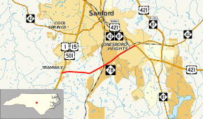
North Carolina Highway 78 (NC 78) is a primary state highway in the U.S. state of North Carolina. The highway connects the Tramway community with Sanford's Jonesboro Heights neighborhood.
Route description
NC 78 is a 4.6-mile (7.4 km) two-lane highway, traversing from US 1/US 15/US 501 in Tramway, to US 421 Business/NC 42/NC 87 in Jonesboro Heights. The routing provides a southern bypass of downtown Sanford.
History
Established in late 1940 as a renumbering of NC 93; NC 78 went from US 1/US 15/US 501 in Tramway, to US 421 in Jonesboro (today Jonesboro Heights). In 1961, NC 78 was rerouted from its terminus at Main Street and Lee Street (now Lee Avenue), to Woodland Avenue and Lee Street (today Horner Boulevard), in Sanford.[3] By the late-1960s, NC 78 was rerouted again to its current terminus with Horner Boulevard.
Originally, the first NC 78 existed from 1934-1940, traversing from NC 79 in Gibson to US 74 near Hamlet. Around 1938, it was rerouted from Grace Chapel Road to US 74. In 1940, it was renumbered as NC 381, which was synched with SC 381 in South Carolina.
Junction list
The entire route is in Lee County.
| Location | mi[2] | km | Destinations | Notes | |
|---|---|---|---|---|---|
| Tramway | 0.0 | 0.0 | |||
| Sanford | 4.6 | 7.4 | |||
| 1.000 mi = 1.609 km; 1.000 km = 0.621 mi | |||||
References
- ↑ "NCDOT GIS Data Layers". North Carolina Department of Transportation. 2012. Retrieved December 28, 2012.
- 1 2 Google (June 16, 2013). "North Carolina Highway 78" (Map). Google Maps. Google. Retrieved June 16, 2013.
- ↑ "NC 78 Route Change (1961-12-07)" (PDF). North Carolina Department of Transportation. December 7, 1961. Retrieved June 16, 2013.
External links
Route map:

- NCRoads.com: N.C. 78