Ingrandes-Le Fresne sur Loire
| Ingrandes-Le Fresne sur Loire | |
|---|---|
| Commune | |
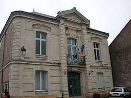 The town hall in Ingrandes | |
 Ingrandes-Le Fresne sur Loire Location within Pays de la Loire region  Ingrandes-Le Fresne sur Loire | |
| Coordinates: 47°24′14″N 0°55′16″W / 47.404°N 0.921°WCoordinates: 47°24′14″N 0°55′16″W / 47.404°N 0.921°W | |
| Country | France |
| Region | Pays de la Loire |
| Department | Maine-et-Loire |
| Arrondissement | Angers |
| Canton | Chalonnes-sur-Loire |
| Area1 | 12.94 km2 (5.00 sq mi) |
| Population (2015)2 | 2,633 |
| • Density | 200/km2 (530/sq mi) |
| Time zone | UTC+1 (CET) |
| • Summer (DST) | UTC+2 (CEST) |
| INSEE/Postal code | 49160 /49123 |
|
1 French Land Register data, which excludes lakes, ponds, glaciers > 1 km2 (0.386 sq mi or 247 acres) and river estuaries. 2 Population without double counting: residents of multiple communes (e.g., students and military personnel) only counted once. | |
Ingrandes-Le Fresne sur Loire is a commune in the Maine-et-Loire department of western France. The municipality was established on 1 January 2016 and consists of the former communes of Ingrandes and Le Fresne-sur-Loire (previously part of the Loire-Atlantique department).[1][2]
See also
References
| Wikimedia Commons has media related to Ingrandes-Le Fresne sur Loire. |
- ↑ Arrêté DRCL-BCL no 2015-116 du 31 décembre 2015 portant création de la commune nouvelle d’Ingrandes-Le Fresne sur Loire, Recueil des actes administratifs de la préfecture de Maine-et-Loire, no 100, 31 décembre 2015 (PDF; 2,9 MB)
- ↑ The French spelling rules on municipalities require all parts of a name to be joined by hyphens, however, in Art.2 of the Arrêté préfectoral, the name was fixed to have only one hyphen between the names of the former municipalities.
This article is issued from
Wikipedia.
The text is licensed under Creative Commons - Attribution - Sharealike.
Additional terms may apply for the media files.