Chanteloup-les-Bois
| Chanteloup-les-Bois | ||
|---|---|---|
| Commune | ||
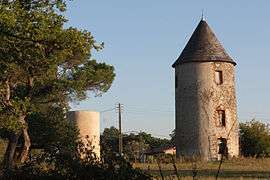 The Mills of Péronne | ||
| ||
 Chanteloup-les-Bois Location within Pays de la Loire region  Chanteloup-les-Bois | ||
| Coordinates: 47°05′44″N 0°41′03″W / 47.0956°N 0.6842°WCoordinates: 47°05′44″N 0°41′03″W / 47.0956°N 0.6842°W | ||
| Country | France | |
| Region | Pays de la Loire | |
| Department | Maine-et-Loire | |
| Arrondissement | Cholet | |
| Canton | Cholet-2 | |
| Intercommunality | CA Choletais | |
| Government | ||
| • Mayor (2008–2014) | Emmanuel Duwattez | |
| Area1 | 27.47 km2 (10.61 sq mi) | |
| Population (2006[1])2 | 670 | |
| • Density | 24/km2 (63/sq mi) | |
| Demonym(s) | Cantelupien, Cantelupienne | |
| Time zone | UTC+1 (CET) | |
| • Summer (DST) | UTC+2 (CEST) | |
| INSEE/Postal code | 49070 /49340 | |
| Elevation |
128–191 m (420–627 ft) (avg. 175 m or 574 ft) | |
|
1 French Land Register data, which excludes lakes, ponds, glaciers > 1 km2 (0.386 sq mi or 247 acres) and river estuaries. 2 Population without double counting: residents of multiple communes (e.g., students and military personnel) only counted once. | ||

Chanteloup-les-Bois is a commune in the Maine-et-Loire department of western France.
See also
References
| Wikimedia Commons has media related to Chanteloup-les-Bois. |
This article is issued from
Wikipedia.
The text is licensed under Creative Commons - Attribution - Sharealike.
Additional terms may apply for the media files.