Ingrandes, Maine-et-Loire
| Ingrandes | ||
|---|---|---|
 | ||
| ||
 Ingrandes Location within Pays de la Loire region  Ingrandes | ||
| Coordinates: 47°24′11″N 0°55′20″W / 47.4031°N 0.9222°WCoordinates: 47°24′11″N 0°55′20″W / 47.4031°N 0.9222°W | ||
| Country | France | |
| Region | Pays de la Loire | |
| Department | Maine-et-Loire | |
| Arrondissement | Angers | |
| Canton | Chalonnes-sur-Loire | |
| Intercommunality | Communauté de communes Loire-Layon | |
| Government | ||
| • Mayor (2008–2014) | Thierry Millon | |
| Area1 | 6.65 km2 (2.57 sq mi) | |
| Population (2006[1])2 | 1,552 | |
| • Density | 230/km2 (600/sq mi) | |
| Demonym(s) | Ingrandais, Ingrandaise | |
| Time zone | UTC+1 (CET) | |
| • Summer (DST) | UTC+2 (CEST) | |
| INSEE/Postal code | 49160 /49123 | |
| Elevation | 7–69 m (23–226 ft) | |
|
1 French Land Register data, which excludes lakes, ponds, glaciers > 1 km2 (0.386 sq mi or 247 acres) and river estuaries. 2 Population without double counting: residents of multiple communes (e.g., students and military personnel) only counted once. | ||
.svg.png)
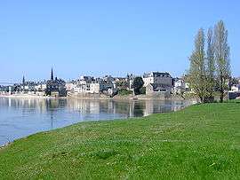
Ingrandes is a former commune in the Maine-et-Loire department in western France. On 1 January 2016, it was merged into the new commune of Ingrandes-le-Fresne-sur-Loire.[2]
See also
References
- ↑ populations légales 2006 sur le site de l’INSEE
- ↑ Arrêté préfectoral Archived 2016-02-15 at the Wayback Machine. 31 December 2015
| Wikimedia Commons has media related to Ingrandes (Maine-et-Loire). |
This article is issued from
Wikipedia.
The text is licensed under Creative Commons - Attribution - Sharealike.
Additional terms may apply for the media files.