Seiches-sur-le-Loir
| Seiches-sur-le-Loir | ||
|---|---|---|
| Commune | ||
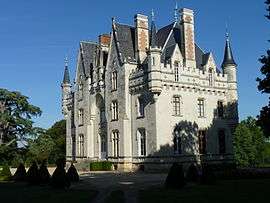 The Château of Brignac | ||
| ||
 Seiches-sur-le-Loir Location within Pays de la Loire region  Seiches-sur-le-Loir | ||
| Coordinates: 47°34′25″N 0°21′17″W / 47.5736°N 0.3547°WCoordinates: 47°34′25″N 0°21′17″W / 47.5736°N 0.3547°W | ||
| Country | France | |
| Region | Pays de la Loire | |
| Department | Maine-et-Loire | |
| Arrondissement | Angers | |
| Canton | Angers-6 | |
| Government | ||
| • Mayor (2014–2020) | Thierry De Villoutreys | |
| Area1 | 28.83 km2 (11.13 sq mi) | |
| Population (2013[1])2 | 2,974 | |
| • Density | 100/km2 (270/sq mi) | |
| Demonym(s) | Seichois, Seichoise | |
| Time zone | UTC+1 (CET) | |
| • Summer (DST) | UTC+2 (CEST) | |
| INSEE/Postal code | 49333 /49140 | |
| Elevation |
15–64 m (49–210 ft) (avg. 28 m or 92 ft) | |
| Website | Site officiel de la ville de Seiches-sur-le-Loir | |
|
1 French Land Register data, which excludes lakes, ponds, glaciers > 1 km2 (0.386 sq mi or 247 acres) and river estuaries. 2 Population without double counting: residents of multiple communes (e.g., students and military personnel) only counted once. | ||
.svg.png)
Seiches-sur-le-Loir is a commune in the Maine-et-Loire department in western France. It is around 20 km north-east of Angers.
See also
References
| Wikimedia Commons has media related to Seiches-sur-le-Loir. |
| Authority control |
|---|
This article is issued from
Wikipedia.
The text is licensed under Creative Commons - Attribution - Sharealike.
Additional terms may apply for the media files.