Illinois Route 31
| ||||
|---|---|---|---|---|
| Route information | ||||
| Maintained by IDOT | ||||
| Length | 58.41 mi[1] (94.00 km) | |||
| Existed | 1937[2] – present | |||
| Major junctions | ||||
| South end |
| |||
| ||||
| North end |
| |||
| Location | ||||
| Counties | Kendall, Kane, McHenry | |||
| Highway system | ||||
| ||||

Illinois Route 31 (IL 31) is a north–south state road in northeastern Illinois, United States. It travels from U.S. Route 34 (US 34) in Oswego north to US 12, near the Wisconsin state line, just south of Richmond. IL 31 is 58.41 miles (94.00 km) long.[1]
Route description
IL 31 follows the Fox River along the western bank. It parallels IL 25, which travels along the eastern bank of the Fox River. It travels concurrent with IL 120 in McHenry.
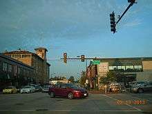
IL 31 is called Richmond Road north of IL 120 and Front Street south of IL 120 in McHenry, Main Street in Algonquin, Western Avenue in Carpentersville, Eighth Street in West Dundee, State Street in Elgin, La Fox Street in South Elgin, Second Street in St. Charles, First Street in Geneva, Batavia Avenue in Batavia, Lincolnway Street in North Aurora, Lake Street (Southbound) and River Street (Northbound) in Aurora, and Lake Street in Montgomery. It is also, along with IL 25, signed as part of the Fox River Valley area. IL 31 between Aurora and Geneva was considered part of the Lincoln Highway transcontinental route.
The Western Algonquin Bypass was completed in 2014[3] and redirects traffic around downtown Algonquin.
History
SBI Route 31 traveled from Quincy to Canton along various routes. This was dropped in 1935. In 1937, it was reapplied along other routes on its modern routing. There have been no changes to the routing since.[2]
U.S. Route 430
| |
|---|---|
| Location | Aurora–Crystal Lake |
| Existed | 1926–1934 |
U.S. Route 430 (US 430) was commissioned from 1926 to 1934 in the U.S. state of Illinois, and traveled from Aurora to Crystal Lake. It traveled concurrent with US 30 from Aurora to Geneva at present-day IL 38. US 430 was dropped in 1934 and replaced in its entirety with IL 31.
Future
McHenry
The intersection of IL 31 and IL 120 is now the most congested intersection in McHenry County.
IDOT is currently in Phase 1 of a planned widening of IL 31 from IL 176 in Crystal Lake to IL 120 in McHenry.[4]
A bypass of McHenry continues to appear in documents planning for a Metra station at Prairie Grove, that include an interchange with the existing IL 31 alignment and the proposed west McHenry bypass alignment to the north of Gracy Road.[5]
The west McHenry bypass was originally planned to travel over undeveloped farm lands from north of IL 31 and Gracy Road to IL 120 and Ringwood Road. The corridor was planned to be protected from development in the mid-1990s, but because of a lack of funding, the corridor was never protected from development[6] and has since been developed.[7]
Algonquin
The Western Algonquin Bypass is not the only limited-access bypass on the table as of 2015.[8] A southern Algonquin bypass is being revived, due to funding constraints, with tolls collected by the Illinois State Toll Highway Authority through I-Pass, and an arterial roadway rather than an expressway on the approaches to the toll bridge. The road would not be part of the Illinois Tollway system though, as is the same for the Chicago Skyway Tollbridge, though I-Pass is accepted on toll bridges. Algonquin Road would not actually be rerouted onto the proposed tollway. There is currently no law against tolling the approaches to a toll bridge and there is no law specifying a maximum length of toll bridge approach roads that can be tolled.
A $1.50 toll to cross the Fox River is proposed. It is unknown if cash would be accepted or if I-Pass users would receive a discount. It is proposed that the toll be removed once the project bonds are paid back.[9]
The Longmeadow Parkway Fox River Bridge Corridor is a proposed four-lane Fox River Bridge crossing and four-lane arterial roadway corridor with a median, approximately 5.6 miles (9.0 km) in length, to alleviate traffic congestion in northern Kane County. The proposed road passes through portions of the villages of Algonquin, Carpentersville, and Barrington Hills, as well as unincorporated areas of Kane County. The western terminus is at Huntley Road west of Randall Road, approximately 1,300 feet (400 m) northwest of the Huntley/Boyer intersection. From Huntley Road to the Fox River, the corridor primarily traverses mostly undeveloped properties or new subdivisions; these subdivisions were developed with a dedicated right-of-way to accommodate the proposed corridor. After crossing the river, the corridor parallels existing Bolz Road, to the eastern project terminus at IL 62.
The project was earmarked $4 million in federal SAFETEA-LU funds, $5 million in federal Surface Transportation Program funds, nearly $1 million in federal Congestion Mitigation and Air Quality funds, nearly $1 million in State of Illinois Truck Access Route Program funds, and an additional $40 million commitment from the State of Illinois. The preliminary construction cost estimate is $97 million.
The proposed Longmeadow Parkway Bridge Corridor is envisioned as a regional roadway stretching from Huntley Road to IL 62 with a new bridge over the Fox River. The project received $4 million in the Federal Transportation Bill (SAFETEA-LU), however with a preliminary construction cost estimate of $97M, many project elements remain unfunded. With limited options to address the funding shortfall, eleven local governments in the Upper Fox Valley region passed resolutions requesting that Kane County consider funding the bridge through a user fee (toll funding). Based upon this request, the Kane County Board agreed to establish a Longmeadow Parkway Toll Bridge Task Force.
County Board approved an amended Phase I Engineering agreement on November 8, 2011 for the work necessary to complete the Phase I Engineering for the corridor (including toll elements). Phase I Design Approval was obtained on December 4, 2013. Clearing the way for Phase II engineering.
In July 2013 the County Board approved engineering agreements with four separate engineering firms to prepare contract documents and obtain environmental permits in preparation for bid opening in late 2015.
County Board approved an amended right-of-way funding agreement which provides over $13.7 million for land acquisition. Land acquisition continues throughout the corridor until this funding is exhausted.
Major intersections
| County | Location | mi[10] | km | Destinations | Notes |
|---|---|---|---|---|---|
| Kendall | Oswego | 0.0 | 0.0 | Southern terminus of IL 31 | |
| Kane | Montgomery | 2.8 | 4.5 | Interchange | |
| Aurora | 5.6 | 9.0 | Southern end of Lincoln Highway concurrency | ||
| North Aurora | 8.6 | 13.8 | Interchange, southern end of IL 56 concurrency | ||
| 9.4 | 15.1 | Northern end of IL 56 concurrency | |||
| 10.3 | 16.6 | ||||
| Batavia | 13.7 | 22.0 | |||
| Geneva | 15.4 | 24.8 | |||
| St. Charles | 17.4 | 28.0 | |||
| Elgin | 26.4 | 42.5 | Interchange | ||
| 29.7 | 47.8 | Interchange | |||
| West Dundee | 31.9 | 51.3 | |||
| McHenry | Algonquin | 37.0 | 59.5 | Western terminus of IL 62; Interchange | |
| Crystal Lake | 41.2 | 66.3 | Interchange | ||
| 42.8 | 68.9 | ||||
| McHenry | 49.5 | 79.7 | Western end of IL 120 concurrency | ||
| 49.9 | 80.3 | Eastern end of IL 120 concurrency | |||
| Richmond | 57.9 | 93.2 | |||
1.000 mi = 1.609 km; 1.000 km = 0.621 mi
| |||||
Algonquin business route
| |
|---|---|
| Location | Algonquin |
| Length | 1.12 mi (1.80 km) |
| Existed | August 31, 2014–present |
Illinois Route 31 Business, also known as Main Street-Algonquin, is a business route that runs about 1.12 miles (1.80 km). Illinois Route 31 Business runs through Algonquin and McHenry County in Illinois. This business route has been announced since October 2013 for the Western Algonquin Bypass groundbreaking. It has already been designated when the Western Algonquin Bypass is completed.
See also

References
- 1 2 Illinois Technology Transfer Center (2007). "T2 GIS Data". Illinois Department of Transportation. Retrieved November 8, 2007.
- 1 2 Carlson, Rich (March 15, 2006). "Routes 21 thru 40". Illinois State Highways Page. Retrieved March 22, 2006.
- ↑ "Algonquin Western Bypass opens to traffic". Northwest Herald. Retrieved 2016-12-08.
- ↑ "Illinois Route 31 Study". Retrieved February 13, 2017.
- ↑ "Town Center & Transit-Oriented Development Plan" (PDF). Village of Prairie Grove, Illinois. Retrieved December 29, 2015.
- ↑ "County Maps Out Bypass". Chicago Tribune. August 8, 1995. Retrieved December 29, 2015.
- ↑ Google (December 29, 2015). "Overview Map of Illinois Route 31" (Map). Google Maps. Google. Retrieved December 29, 2015.
- ↑ "Construction Project: Longmeadow Parkway Bridge Corridor". Kane County Department of Transportation. Retrieved December 29, 2015.
- ↑ "Toll for Longmeadow Parkway is hot topic for Kane Co. Board race". Daily Herald.
- ↑ Google (January 2, 2013). "Illinois Route 31" (Map). Google Maps. Google. Retrieved January 2, 2013.
External links
| Wikimedia Commons has media related to Illinois Route 31. |
Route map: