Illinois Route 15
| ||||
|---|---|---|---|---|
| Route information | ||||
| Maintained by IDOT | ||||
| Length | 149.64 mi[1] (240.82 km) | |||
| Existed | November 5, 1918[2] – present | |||
| Major junctions | ||||
| West end |
| |||
|
| ||||
| East end |
| |||
| Location | ||||
| Counties | St. Clair, Washington, Jefferson, Wayne, Edwards, Wabash | |||
| Highway system | ||||
| ||||

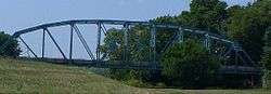
Former eastern terminus of the highway at the Wabash River bridge.
Illinois Route 15 is an east–west highway with its western terminus at Illinois Route 3, U.S. Route 40, I-55, and I-64, and its eastern terminus at Wabash River at the Illinois/Indiana Border where it meets State Road 64. This is a distance of 149.64 miles (240.82 km).[1]
History
West of Mt. Vernon, IL 15 was part of US 460. Until the 1960s, IL 15 went on the IL 160 corridor from Addieville to Okawville, then west on the present IL 177 corridor to Belleville. The section from Nashville to St. Libory was once IL 110, but this was back in the 1940s before US 460 was signed.[1]
The current route was determined in 1967. US 460 was truncated in 1974.[2]
Major intersections
| County | Location | mi[3] | km | Destinations | Notes |
|---|---|---|---|---|---|
| St. Clair | East St. Louis | 0.0 | 0.0 | ||
| west end of National Road overlap | |||||
| east end of National Road overlap | |||||
| Alorton | 3.4 | 5.5 | Northern terminus of IL 163 | ||
| 4.2 | 6.8 | I-255 exit 17 | |||
| Alorton–Centreville line | 5.6 | 9.0 | interchange | ||
| Belleville | 7.7 | 12.4 | interchange; no access from IL 15 east to IL 13 west or IL 13 east to IL 15 west | ||
| Frank Scott Parkway West | interchange | ||||
| 12.1 | 19.5 | interchange | |||
| 13.2 | 21.2 | interchange | |||
| 14.6 | 23.5 | interchange; western end of IL 13 concurrency; westbound exit and eastbound entrance | |||
| Freeburg | 21.0 | 33.8 | Eastern end of IL 13 concurrency | ||
| Fayetteville | 28.0 | 45.1 | Western end of IL 4 concurrency | ||
| St. Libory | 32.6 | 52.5 | Eastern end of IL 4 concurrency | ||
| Washington | Johannisburg Township | 38.7 | 62.3 | Northern terminus of IL 153 | |
| Plum Hill Township | 45.5 | 73.2 | Southern terminus of IL 160 | ||
| Nashville | 51.5 | 82.9 | |||
| Ashley Township | 60.1 | 96.7 | Western end of US 51 concurrency | ||
| 62.9 | 101.2 | Eastern end of US 51 concurrency | |||
| Jefferson | Mt. Vernon | 75.7 | 121.8 | I-57 exit 95 | |
| 78.3 | 126.0 | ||||
| Wayne | Wayne City | 95.8 | 154.2 | Northern terminus of IL 242 | |
| Fairfield | 107 | 172 | Western end of US 45 concurrency | ||
| 110 | 180 | Eastern end of US 45 concurrency | |||
| Edwards | Albion | 126 | 203 | west end of IL 130 concurrency | |
| 127 | 204 | east end of IL 130 concurrency | |||
| Wabash | Mt. Carmel | 148 | 238 | west end of IL 1 concurrency | |
| 149 | 240 | east end of IL 1 concurrency | |||
| 149.64 | 240.82 | Indiana state line (Mount Carmel Bridge over the Wabash River) | |||
1.000 mi = 1.609 km; 1.000 km = 0.621 mi
| |||||
External links
Route map:
References
- 1 2 3 Illinois Technology Transfer Center (2007). "T2 GIS Data". Retrieved 2007-11-08.
- 1 2 Carlson, Rich. Illinois Highways Page: Routes 1 thru 20. Last updated March 15, 2006. Retrieved April 2, 2006.
- ↑ Google Maps,
This article is issued from
Wikipedia.
The text is licensed under Creative Commons - Attribution - Sharealike.
Additional terms may apply for the media files.