Ibestad
| Ibestad kommune Ivvárstáđiid suohkan | |||
|---|---|---|---|
| Municipality | |||
 | |||
| |||
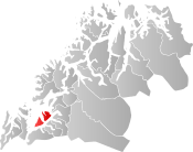 Ibestad within Troms | |||
| Coordinates: 68°49′46″N 17°14′45″E / 68.82944°N 17.24583°ECoordinates: 68°49′46″N 17°14′45″E / 68.82944°N 17.24583°E | |||
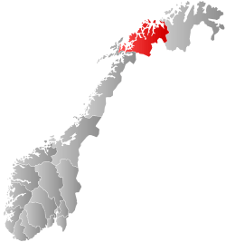
| Country | Norway | ||
| County | Troms | ||
| District | Hålogaland | ||
| Established | 1 Jan 1838 | ||
| Administrative centre | Hamnvik | ||
| Government | |||
| • Mayor (2011) | Dag Brustind (H) | ||
| Area | |||
| • Total | 241.06 km2 (93.07 sq mi) | ||
| • Land | 234.16 km2 (90.41 sq mi) | ||
| • Water | 6.90 km2 (2.66 sq mi) 2.8% | ||
| Area rank | #312 in Norway | ||
| Population (2017) | |||
| • Total | 1,394 | ||
| • Rank | #362 in Norway | ||
| • Density | 6.0/km2 (16/sq mi) | ||
| • Change (10 years) | -11.4% | ||
| Demonym(s) | Ibestadværing[1] | ||
| Time zone | UTC+01:00 (CET) | ||
| • Summer (DST) | UTC+02:00 (CEST) | ||
| ISO 3166 code | NO-1917 | ||
| Official language form | Bokmål | ||
| Website |
ibestad | ||

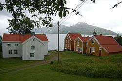
Ibestad (Northern Sami: Ivvárstádik) is a municipality in Troms county, Norway. It is part of the traditional region of Central Hålogaland. The administrative centre of the municipality is the village of Hamnvik. Some of the other larger villages in Ibestad include Engenes, Laupstad, Rollnes, Sørrollnes, Sørvika, and Å.
The 241-square-kilometre (93 sq mi) municipality is the 312th largest by area out of the 422 municipalities in Norway. Ibestad is the 362nd most populous municipality in Norway with a population of 1,394. The municipality's population density is 6 inhabitants per square kilometre (16/sq mi) and its population has decreased by 11.4% over the last decade.[2]
General information

The municipality of Ibestad was established on 1 January 1838 (see formannskapsdistrikt). Initially, Ibestad municipality covered a large area from the Vågsfjorden to the border with Sweden (the old Astafjord church parish). In 1854, the rural eastern half of the municipality (population: 757) was separated from Ibestad to form the new Bardu Municipality. This left Ibestad with 4,741 residents.
Then, on 1 January 1871, the northeastern part of the municipality (population: 1,384) was separated from Ibestad to form the new Salangen Municipality. This left Ibestad with 4,301 inhabitants. On 1 January 1907, the easternmost area of Ibestad (population: 1,536) became the separate Lavangen Municipality. Ibestad had 5,709 residents remaining after the split. In 1926, the municipality of Ibestad was divided into four separate municipalities: Andørja (population: 1,420) in the northeast, Gratangen (population: 1,967) in the southeast, Astafjord (population: 1,018) in the southwest, and (a much smaller) Ibestad (population: 1,768) in the northwest.
During the 1960s, there were many municipal mergers across Norway due to the work of the Schei Committee. On 1 January 1964, the municipality of Ibestad (population: 1,821) was merged with the municipality of Andørja (population: 1,330) and the part of Skånland Municipality located on the island of Rolla (population: 143), creating a new Ibestad Municipality with a total of 3,294 residents.[3]
Name
The municipality (originally the parish) is named after the old Ibestad farm (Old Norse: Ívarsstaðir), since the first Ibestad Church was built there. The first element is the genitive case of the male name Ívarr and the last element is staðir which means "homestead" or "farm". Prior to 1918, the name was spelled Ibbestad.[4]
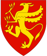
Coat of arms
The coat of arms is modern and it was approved on 19 December 1986. The blue and white arms symbolize one of the oldest Norwegian stone churches. The church was built in Ibestad around the year 1200. As a symbol for this church, the arms show a cross on a medieval tombstone that was found at the church in 1960.[5]
Churches
The Church of Norway has two parishes (sokn) within the municipality of Ibestad. It is part of the Trondenes prosti (deanery) in the Diocese of Nord-Hålogaland.
| Parish (Sokn) | Church Name | Location of the Church | Year Built |
|---|---|---|---|
| Andørja | Andørja Church | Engenes | 1914 |
| Ibestad | Ibestad Church | Hamnvik | 1881 |
| Sørrollnes Chapel | Sørrollnes | 1976 |
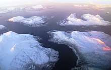
Geography
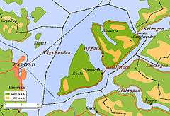
The municipality encompasses the islands of Andørja and Rolla and the tiny surrounding islets. The two main islands are connected by the undersea Ibestad Tunnel. The Mjøsund Bridge connects Andørja to Salangen Municipality on the mainland. There is a regular ferry connection from Sørrollnes on Rolla to the town of Harstad.
The Astafjorden forms the southeastern border of the municipality and the Vågsfjorden forms the western and northern borders. The small Mjøsundet strait forms the eastern border. The highest point in Ibestad is the 1,276-metre (4,186 ft) tall Langlitinden mountain.
Climate
| Climate data for Hamnvik | |||||||||||||
|---|---|---|---|---|---|---|---|---|---|---|---|---|---|
| Month | Jan | Feb | Mar | Apr | May | Jun | Jul | Aug | Sep | Oct | Nov | Dec | Year |
| Daily mean °C (°F) | −3.4 (25.9) |
−3.1 (26.4) |
−1.5 (29.3) |
1.6 (34.9) |
6.2 (43.2) |
10.0 (50) |
12.4 (54.3) |
11.9 (53.4) |
8.0 (46.4) |
3.9 (39) |
−0.1 (31.8) |
−2.4 (27.7) |
3.6 (38.5) |
| Average precipitation mm (inches) | 89 (3.5) |
82 (3.23) |
66 (2.6) |
56 (2.2) |
42 (1.65) |
49 (1.93) |
63 (2.48) |
74 (2.91) |
99 (3.9) |
128 (5.04) |
97 (3.82) |
105 (4.13) |
950 (37.4) |
| Source: Norwegian Meteorological Institute[6] | |||||||||||||
Government
All municipalities in Norway, including Ibestad, are responsible for primary education (through 10th grade), outpatient health services, senior citizen services, unemployment and other social services, zoning, economic development, and municipal roads. The municipality is governed by a municipal council of elected representatives, which in turn elect a mayor.[7] The municipality falls under the Trondenes District Court and the Hålogaland Court of Appeal.
Municipal council
The municipal council (Kommunestyre) of Ibestad is made up of 19 representatives that are elected to four year terms. Currently, the party breakdown is as follows:[8]
| Party Name | Name in Norwegian | Number of representatives | |
|---|---|---|---|
| Labour Party | Arbeiderpartiet | 4 | |
| Conservative Party | Høyre | 6 | |
| Centre Party | Senterpartiet | 3 | |
| Liberal Party | Venstre | 1 | |
| Local Lists | Lokale lister | 5 | |
| Total number of members: | 19 | ||
References
- ↑ "Navn på steder og personer: Innbyggjarnamn" (in Norwegian). Språkrådet. Retrieved 2015-12-01.
- ↑ Statistisk sentralbyrå (2017). "Table: 06913: Population 1 January and population changes during the calendar year (M)" (in Norwegian). Retrieved 2017-09-09.
- ↑ Jukvam, Dag (1999). "Historisk oversikt over endringer i kommune- og fylkesinndelingen" (PDF) (in Norwegian). Statistisk sentralbyrå.
- ↑ Rygh, Oluf (1911). Norske gaardnavne: Troms amt (in Norwegian) (17 ed.). Kristiania, Norge: W. C. Fabritius & sønners bogtrikkeri. p. 40.
- ↑ "Civic heraldry of Norway - Norske Kommunevåpen". Heraldry of the World. Retrieved 2018-08-28.
- ↑ "eKlima Web Portal". Norwegian Meteorological Institute. Archived from the original on 2004-06-14.
- ↑ Hansen, Tore, ed. (2016-05-12). "kommunestyre". Store norske leksikon (in Norwegian). Kunnskapsforlaget. Retrieved 2018-08-28.
- ↑ "Table: 04813: Members of the local councils, by party/electoral list at the Municipal Council election (M)" (in Norwegian). Statistics Norway.
External links


- Municipal fact sheet from Statistics Norway (in Norwegian)

| |||||||||
| |||||||||
| |||||||||
| Authority control |
|---|