Hurricane Luis
| Category 4 major hurricane (SSHWS/NWS) | |
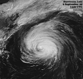
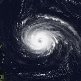 Hurricane Luis near peak intensity east of the Lesser Antilles on September 3 | |
| Formed | August 28, 1995 |
|---|---|
| Dissipated | September 12, 1995 |
| (Extratropical after September 11) | |
| Highest winds |
1-minute sustained: 140 mph (220 km/h) |
| Lowest pressure | 935 mbar (hPa); 27.61 inHg |
| Fatalities | 19 total |
| Damage | $2.97 billion (1995 USD) |
| Areas affected | Leeward Islands (especially Antigua and Barbuda, Guadeloupe, Dominica, St. Kitts and Nevis, Sint Eustatius, Saba, St. Barthelemy, St. Martin and Anguilla), Virgin Islands, Puerto Rico, Bermuda, parts of the Northeastern USA, Newfoundland |
| Part of the 1995 Atlantic hurricane season | |
Hurricane Luis was a long-lived and powerful Cape Verde hurricane, as well as one of the strongest, deadliest, and most notable hurricanes of the 1995 Atlantic hurricane season, with maximum sustained winds of 140 mph (220 km/h) – which would nearly be tied with Opal later that year but surpassed it by minimum pressure. Luis was also the strongest hurricane to make landfall, and the third-most intense hurricane recorded during the extremely active season. The storm was the twelfth tropical storm, sixth hurricane, and second major hurricane of the season. At one point, the storm was one of four simultaneous tropical systems in the Atlantic basin, along with Humberto, Iris, and Karen. The storm lasted for 14 days as a tropical storm between late August and mid-September.
The system formed from a tropical wave south of Cape Verde islands, west of Africa on August 27, then subsequently attained tropical storm status on August 29. Two days later, the storm reached hurricane status; shortly thereafter, it rapidly strengthened into a 140 mph (220 km/h) Category 4 hurricane.[1] At this strength, Luis affected much of the Leeward Islands on September 4 to September 6. Throughout the following days, Luis gradually weakened as it accelerated safely to the west of Bermuda. As a Category 1 hurricane, Luis made landfall on Newfoundland before it became extratropical on September 11.
Luis caused catastrophic damage in Barbuda, St. Barthelemy, St Martin and Anguilla as a Category 4 with winds between 130 mph (210 km/h) and 135 mph (217 km/h). The storm accounted for 19 deaths, left between 20,000 and 50,000 homeless (mostly in Antigua, Barbuda, Anguilla and Saint Martin) and caused roughly $3 billion (1995 USD) in damage across the affected areas. Hurricane Luis was the most devastating hurricane to strike the northern Leeward Islands in the 20th century and one of the strongest storms to hit the Leeward Islands at the time, along with Hurricane David in 1979 and Hurricane Hugo in 1989. Additionally, Luis was the second of three tropical cyclones to affect Guadeloupe in a short period of time, the first being Hurricane Iris a week before, and the last being Hurricane Marilyn only ten days afterward. During the next year, the Leeward Islands would be struck by Hurricane Bertha, while still repairing from Luis and Marilyn, then successively hit by Hortense, Erika, Georges, Jose, Lenny and Debby.
Luis was also responsible for an intense rogue wave, which struck RMS Queen Elizabeth 2 on Monday, September 11, though the ship pulled through with little damage.
Meteorological history
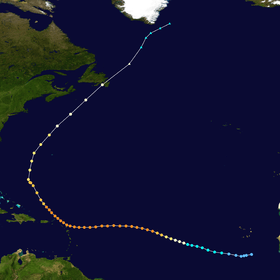
The origins of Hurricane Luis trace back to an area of disturbed weather associated with a tropical wave over the eastern Atlantic Ocean, on August 26. A low-level circulation center formed and moved westward until it developed a weak surface low on August 27; consequently, a tropical depression was designated at 1200 UTC that day. The depression attained 36 hours later into a Tropical Storm named "Luis" on August 29. Though convective activity fluctuated for the next two days as a result of nearby wind shear, the storm slowly intensified while pressure rose. The shear relented the next day, allowing an eye to gradually form, and the system attained hurricane status thereafter on early August 31, then a Category 3 major hurricane 18 hours later.[1]
Hurricane Luis continued to strengthen as it tracked west-northwestward into a Category 4 on the Saffir-Simpson Hurricane Scale on September 2 and the cyclone turned more towards the west earlier that day as it maintained a rectilinear slow motion; the intensity was confirmed by a reconnaissance flight on September 3. At this time, it was located approximately 540 miles (870 km) to the east of the Lesser Antilles. The storm began to slightly accelerate as it moved along a subtropical ridge due to the absorption of Karen by the stronger Iris.[1]
By the day of September 4, Luis sustained a large wind field as it approach the Lesser Antilles, its tropical storm-force winds measured from 345 mi (555 km) to 365 mi (587 km) in diameter as it begin to affected in the night Antigua, Barbuda, Dominica and Guadeloupe. On the morning of September 5, islands such as Dominica and even the islands of Guadeloupe, where it experienced hurricane-force winds on the northeastern coast of Grande-Terre and Désirade, has been relatively spared by the storm. However the eyewall of the hurricane skimed Antigua and directly passing over Barbuda while weakened slightly. During the time, it proceeded slowly northwestward affecting Montserrat, Saint Kitts and Nevis, Sint Eustatius and Saba causing moderate damage. Later, Luis moved along St. Barthelemy, St. Martin and ultimately crossed Anguilla, where maximum sustained winds within the eyewall were estimated to have reached 135 mph (217 km/h), and its central pressure had dropped from 945 to 942 mbar (27.9 to 27.8 inHg).[1]
A large and powerful hurricane, Luis retained Category 4 intensity until September 7, while situated about 150 mi (240 km) to the north of Puerto Rico. The storm gradually re-curved over the northern Atlantic as a Category 2 storm, after having spent 7 consecutive days as a major hurricane with maximum sustained winds of at least 115 mph (185 km/h), from September 1 to 8. From there on, the center of the storm passed 200 miles (320 km) to the west of Bermuda on September 9 causing minor damage, and then later weakened to a Category 2 hurricane, with winds of 110 mph (165 km/h).[2] Several hours later, the hurricane made its closest approach to Bermuda, passing about 200 mi (320 km) west of the island.[1] Later that day, the storm began to accelerate as it traveled northeast ahead of a strong trough located to the northwest of Luis.[3] During the afternoon of September 10, Hurricane Luis began to undergo an extratropical transition as it rapidly approached the Canadian coastline.[4] Due to the rapid movement of the storm, significant weakening did not occur until Luis was at an unusually high latitude as the central pressure of the storm decreased to 961 mbar (28.38 inHg) but sustained winds did not exceed 90 mph (140 km/h) according to the NHC.[1][5]
Luis maintained this intensity until it made landfall on the Avalon Peninsula in eastern Newfoundland early on September 11.[1][6] While tracking over Newfoundland, cold, dry air became entrenched in Luis's circulation and the system began to merge with the approaching trough. The NHC issued their final advisory on Hurricane Luis at 0900 UTC on September 11, as the system tracked nearly 65 mph (100 km/h) to the northeast and transitioned into an extratropical cyclone on September 11, and moved ashore on eastern Newfoundland.[1][7] The extratropical remnants of Luis persisted for 30 more hours over the North Atlantic Ocean, before being absorbed by the trough near the southern coast of Greenland, late on September 12.[1]
Preparations
Three days before devastation occurred in the northern Lesser Antilles, Hurricane Luis became a Category 4 hurricane and was forecasted to avoid those area well to the north, following Humberto and Karen. However, as Karen neared Iris, it weakened and was absorbed by a stronger Iris while influenced by the subtropical ridge, which ended up steering Luis to the west.
Leeward Islands and Puerto Rico
Due to its slow motion, giving local officials ample time to prepare. In advance of the storm, tropical cyclone watches and warnings were declared in several areas throughout the Caribbean. Seventeen watches and/or warnings were issued in association with Luis. The first two were a hurricane watch issued on Antigua, Barbuda and Guadeloupe on September 2 at 2200 UTC. Five hours later, a tropical storm watch was issued for Dominica. At 2100 UTC, a hurricane warning was issued for Antigua, Barbuda and a hurricane watch for Guadeloupe. At 1500 UTC, Puerto Rico was put under a tropical storm watch. At 1700 UTC, Guadeloupe, St. Barthelemy, and French portion of St. Martin were put under a hurricane warning. Four hours later, Puerto Rico, U.S. and British Virgin Islands were put under a tropical storm warning, this is including Martinique and Saint Lucia.[1]
Bermuda and Canada
Additionally, a tropical storm warning was also issued for Bermuda on September 7, all of which were canceled by September 10. However, there were no tropical storm watches or warnings issued for any part of Atlantic Canada.[1]
Impact
| County/Region | Deaths | Damage | Source |
|---|---|---|---|
| Antigua and Barbuda | 3 | $350 million | [1] |
| Guadeloupe | 1 | $50 million | [1][8] |
| Dominica | 2 | $47 million | [1][9] |
| Montserrat | 0 | $20 million | [8] |
| Saint Kitts and Nevis | 0 | $197 million | [1] |
| Saint Martin | 9 | $1.8 billion | [1] |
| Puerto Rico | 2 | $200 million | [1][8] |
| United States | 1 | $1.9 million | [10][11] |
| Virgin Islands | 0 | $300 million | [8] |
| Newfoundland | 1 | $0.5 million | [1] |
| Total | 19 | ~$3 billion |
Leeward Islands
Overall, Luis caused extensive crop and property damage across the Leeward Islands due to its high associated powerful winds and heavy rainfall. The exact amount of damage caused by the storm is unknown due to lack of reports from affected areas since Iris, though it is estimated at $3 billion (1995 USD).
Antigua and Barbuda
As a result of a direct hit from the Category 4 hurricane, Barbuda experienced extensive damage to residences from 135 mph winds and over 10 inches (250 mm) of rain. According to the islands' Prime Minister, a great number of houses were damaged or destroyed in Barbuda, and nearly 45% of the residences on Antigua were eradicated by the hurricane as it passed 25 miles (40 km) to the north of the island.[1] Across the islands, numerous inhabitants experienced power outages and disrupted water systems. The storm ultimately accounted for three deaths and injured 165 locals; 32.000 inhabitants on both islands were greatly affected, forced 1,700 people to take shelter and left approximately 3,200 others homeless. Throughout the country, the total damage from the storm was estimated $350 million (most from Barbuda) or 60% of the country's GDP worth of damage was assessed.[12]
International aid was sought after the storm had made its passing, with shelter and food supplies being the most needed.
Guadeloupe
| Precipitation | Storm | Location | Ref. | ||
|---|---|---|---|---|---|
| Rank | mm | in | |||
| 1 | 582 | 22.91 | Luis 1995 | Dent de l'est (Soufrière) | |
| 2 | 508 | 20.00 | Marilyn 1995 | Saint-Claude | [13] |
| 3 | 466 | 18.35 | Lenny 1999 | Gendarmerie | [14] |
| 4 | 389 | 15.31 | Hugo 1989 | ||
| 5 | 318 | 12.52 | Hortense 1996 | Maison du Volcan | [15] |
| 6 | 300 | 11.81 | Jeanne 2004 | [16] | |
| 7 | 223.3 | 8.79 | Cleo 1964 | Deshaies | [13] |
| 8 | 200 | 7.87 | Erika 2009 | [17] | |
| 9 | 165.3 | 6.51 | Earl 2010 | Sainte-Rose (Viard) | [18] |
| 10 | 53.6 | 2.11 | Edith 1963 | Basse Terre | [13] |
Luis caused some damage as it passed 60 miles (97 km) north of Guadeloupe, essentially of Grande-Terre. Hurricane-force condition resulted in of moderate damage to homes and roofs, uprooted trees, and severe beach erosion. Meanwhile, the Basse-Terre region received minor damage, except to banana crops that been damaged at nearly 90% and sugar cane crops on the north at nearly 20%. Additionally, 5 to 11 inches (130 to 280 mm) of rain were recorded in the islands while the mountains regions recorded up to 20 inches (510 mm) as the highest rainfall was 22.91 inches (582 mm) in La Grande Soufrière within the 48-hour period, that damaged some roads specifically in the west coast where high waves washed houses and coastal road.[19] The meteorological office in Raizet recorded sustained winds of 48 miles per hour (77 km/h) with gusts reached 65 miles per hour (105 km/h), reported a fall in minimal pressure to 994 mb (29.36 In Hg) around 3 to 4 am on September 5 and a total 178 millimetres (7.0 in) of rain during the whole period. Only the easternmost island Desirade, recorded a hurricane force-wind at 75 miles per hour (121 km/h) and a sustained gust at 89 miles per hour (143 km/h) between 3 and 4 on September 5[1] and a 992 mb (29.29 In Hg) pressure. The storm claimed the life of a 29-year-old French tourist, who had been dragged away by vigorous waves on a pier in eastern Saint-François.[20] The total damage estimated at 250 millions of francs (50 millions USD), especially for the crops and the roads.
St. Barthelemy
The islands suffered extensive damages from 135 mph (215 km/h) winds as the hurricane passed 155 miles (25 km) north of Saint Barthelemy. The main weather station recorded wind speeds of 125 mph (200 km/h) and gusts of up to 155 mph (250 km/h);[1] this difference may be due to local effects produced by mountainous terrain on the island and the aircraft sampling winds at a level above the region of maximum winds. Additionally, minimal recorded pressure was at 948 mbar (28.0 inHg) as the storm made its closest approach and stay below 1,000 mbar (30 inHg) for at least 24 hours period.[21]
St. Martin
| Precipitation | Storm | Location | Ref. | ||
|---|---|---|---|---|---|
| Rank | mm | in | |||
| 1 | 700.0 | 27.56 | Lenny 1999 | Meteorological Office, Phillpsburg | [22] |
| 2 | 280.2 | 11.03 | Jose 1999 | Princess Juliana International Airport | [23] |
| 3 | 165.1 | 6.50 | Luis 1995 | [24] | |
| 4 | 111.7 | 4.40 | Otto 2010 | Princess Juliana International Airport | [25] |
| 5 | 92.3 | 3.63 | Rafael 2012 | Princess Juliana International Airport | [26] |
| 6 | 7.9 | 0.31 | Ernesto 2012 | Princess Juliana International Airport | [26] |
| 7 | 7.0 | 0.28 | Chantal 2013 | Princess Juliana International Airport | [27] |
| 8 | 6.6 | 0.26 | Dorian 2013 | Princess Juliana International Airport | [27] |
The island received the hardest condition of the eyewall as Luis passed 15 miles (24 km) to 20 miles (32 km) northeast of St. Martin, causing very extensive damage at 70% and spawning several F3 tornadoes. A total of 6.50 in (165 mm) of rain has been recorded on the island's territory during the 48 hours period.
In Grand Case bay, 90% of the houses were damaged or destroyed as a result of rough sea conditions and very strong winds. Damage was also common in other towns, such as Marigot, French Quarter and Philipsburg, where at least 70% of the city was decimated by the storm. It also caused the Great Salt Pond to deluge several streets, leaving them partially submerged by 1 feet. Of the 1,500 boats sheltered in Simpson Bay Lagoon, nearly 1,300 or 85% were sunken or run aground. Furthermore, the hurricane affected 32,000 on which 7,000 were left people homeless (5,000 Haitians on their district in Marigot). At least 60% of the residences of the island's 50,000 people were damaged as nearly 15% of them were completely destroyed as some of them made uninhabitable, this is including businesses, churches, hotels (4 of them been destroyed), and some schools. Some towns in the island spent nearly 3 months without water and power. Luis killed nine people (two in the French side and seven drowned in the Dutch side).
Princess Juliana Airport recorded 87 mph (140 km/h) sustained winds with maximum gusts of 114 mph (183 km/h); the barometric pressure at its lowest fell between 963 to 964 mbar (28.4 to 28.5 inHg). The Met office on the French side (Grand Case airport) of the island also measured a wind gust of 202 mph (325 km/h) while an unofficial anenometer in Marigot's "marina" recorded wind gusts around 126 mph (203 km/h). Tropical storm-force winds brushed the islands for approximately 21 hours, while hurricane-force sustained winds lasted up to 8 hours as the hurricane passed with minimal forward speed between 7 mph (11 km/h) to 9 mph (14 km/h). Total damages in both sides (French and Dutch) was astronomic, accounted for $1.8 billion (1995 USD) worth of damage.[28] As such, Luis was the most devastating Hurricane to hit the islands since Hurricane Donna in 1960.
Anguilla
The eye of the hurricane passed over the northeastern tip of Anguilla. Although the island would have sustained worst damage than of St. Martin, total damage was still unknown. Luis was the worst hurricane the island suffered from 1960's Hurricane Donna.
St. Kitts and Nevis
Luis passed nearly 50 miles (80 km) northeast that caused very severe beach erosion,[29] moderate damage to residences and leaving at least 2,000 homeless on Saint Kitts and Nevis. The vegetation and some of the road infrastructure was badly damaged as a result of the storm, with problems essentially arising in relation to the poor water system. Total damage ultimately reached to $197 million.
Dominica
As Luis passed nearly at 120 miles (190 km) north, majority of the damage experienced in Dominica was inflicted to banana crops that had already been damaged from Iris at 70%. While overall damages was fairly minor, beach erosion was common and that disrupt and washed few beach hotels and coastal roads,[29] where about 1,000 people were left homeless, due to rough waves on the northeastern and the western coast of the island's town such as Marigot, Roseau and Portsmouth. 40 miles (64 km) tropical Storm force-wind affected most part of the islands from the earliest on September 5 until the afternoon of September 5 and lowest pressure recorded was between 1,000 to 1,005 mbar (29.5 to 29.7 inHg). Ultimately, a fisherman was confirmed killed due to rough sea conditions.[30] All in all, property damage was estimated at $47 million; the storm contributed to the effects of Hurricane Iris, which had struck the country a week before and Hurricane Marilyn, 10 days after total at $184 million.
Puerto Rico
Luis passed at 120 miles (190 km) northeast of Puerto Rico, causing minor damages in the east.[31] There were two deaths reported in the islands.[20]
Bermuda
Bermuda reported sustained winds of 46 miles per hour (74 km/h); however, little to no damage has been reported. Offshore, the storm produced waves approaching 100 feet (30 m) in height.[1]
Eastern United States and offshore
Rough seas from the storm affected the U.S. East Coast, resulting in some beach erosion and damage to two waterfront structures on Fire Island.[32] On September 7, rip currents produced by Luis caused the death of one person near Corncake Inlet, North Carolina.[33] High waves, in combination with high tide, caused significant beach erosion and coastal flooding. In Brunswick County, eight homes were washed away by the waves and 40 feet (12 m) of beach was lost. In Hyde, Carteret, and Onslow Counties, waves up to 17 feet (5.2 m) washed out 33 feet (10 m) of the Triple S Pier in Atlantic Beach was destroyed. Total losses in North Carolina amounted to $1.9 million.[34][35][36] In New York, rough seas undermined one home, destroyed it and led to the death of one person who was swimming in the high waves.[10][11]
On September 11, a rogue wave triggered by Luis slammed Queen Elizabeth 2 when it was about 200 nautical miles (370 km; 230 mi) south of eastern Newfoundland.[4][37] At about the same time, a nearby Canadian buoy recorded a 98-foot wave (30 m).[1] Though the ship did not sustain any significant damage, its arrival in New York was delayed considerably.[38]
Atlantic Canada
Throughout eastern Newfoundland, the system dropped 2.4 to 4.7 inches (61 to 119 mm) of rain at its landfall as a Category 1.[39] Northwesterly winds there gusted to 81 mph (130 km/h).[4] The storm caused minor damage to the large province. One storm-related death was reported in Canada.[1] Flooding from Luis caused an estimated $500,000 in damages.[40]
Aftermath and economic impact
Antigua, Barbuda, Dominica and St. Kitts and Nevis
By September 29, the Office for the Coordination of Humanitarian Affairs provided both Antigua and Barbuda and the Netherlands Antilles with $50,000 in emergency funds. Furthermore, the United Nations Development Programme provided $50,000 for both Barbados and the Netherlands Antilles. For the reconstruction of schools, the United Nations Educational, Scientific and Cultural Organization provided $20,000 to Antigua and Barbuda, $15,000 to Dominica, and $5,000 to St. Kitts and Nevis. The United Nations Children's Fund provided a cash grant of $20,000 to all the affected islands. The European Community Humanitarian Aid Office provided relief goods, such as plastic sheeting, water containers, blankets, and basic medical supplies worth $1.2 million. The Organization of American States provided an emergency cash grant of $250,000 for Antigua and Barbuda, Dominica, and St. Kitts and Nevis. The Government of Australia provided Antigua and Barbuda with $37,593 in relief funds; the Government of the Bahamas provided $50,000 to the affected areas in emergency funds; the Government of Canada donated $149,253 to the Pan American Health Organization and $44,760 to the affected areas; the Government of France contributed $200,000 in emergency funds to Antigua and Barbuda; the Government of Germany provided $52,817 in emergency funds to St. Kitts and Nevis; the Government of Jamaica deployed military recovery teams to affected regions to assist with rehabilitation and cleanup efforts; the Government of Japan contributed $150,000 in emergency funds to the affected region; the Government of Norway provided $50,000 in cash assistance to Antigua and Barbuda and St. Kitts and Nevis; the Government of the Netherlands provided $15.2 million in emergency funds and recovery funds to the Netherlands Antilles; the Government of New Zealand provided a cash assist of $32,942 to Antigua and Barbuda; the Government of Spain contributed $15,873 in emergency funds to the affected regions.[41]
Saint Martin
Aside from high winds and seas, possible explanation for the storm's heavy damage may have been complacency on the part of local island populations and their houses.[1] Another factual reason was substantial difference in wind speed forecasts measured at sea-level Princess Juliana Airport on the Dutch side and those measured on homes throughout the island hillsides & broadcast from sites off the island. Sea-level Airport readings showed 86 mph (139 km/h) sustained winds and winds gusting to 114 mph (183 km/h).[21] Whereas measurements on some hillside homes and especially the airport on the north of the French side, between two mountains, showed wind gusts between 170 and 205 mph (275 and 330 km/h). A sailor that been sheltered in the lagoon recorded a 115 mph (185 km/h) winds gusting and a minimal pressure reading to 965 mbar (28.5 inHg).[42]
Records and retirement
When Tropical Depression Thirteen strengthened into Tropical Storm Luis on August 29, it marked the earliest date on which the twelfth named storm of any season formed, surpassing the previous record set by Tropical Storm Twelve of the 1933 season.
Shortly before becoming extratropical, Hurricane Luis was moving at 65 mph (105 km/h), becoming one of the fastest moving Atlantic hurricanes in recorded history.[43]
On September 11, a 98 feet (30 m) wave struck an ocean liner. This wave is the largest wave ever recorded;[44] however, Hurricane Ivan in 2004 may have produced a wave up to 130 feet (40 m) high off the coast of Mexico.[45]
Since 1950, there have been very few Atlantic hurricanes that have had an Accumulated cyclone energy (ACE) index over 50. As it spent nearly fourteen days as a named storm, Luis achieved and ACE value of 53.5, which was the highest since Inez in 1966 and remained the highest until being surpassed by hurricanes Isabel in 2003, Ivan in 2004, and Irma in 2017.
Due to the severe damage and loss of life caused by the storm in the Leeward Islands, the name "Luis" was retired in the spring of 1996, and will never again be used for an Atlantic hurricane. It was replaced with "Lorenzo" in the 2001 season. Luis was the first Atlantic hurricane name beginning with "L" to have its name retired and the first hurricane to be retired in three years since Hurricane Andrew in 1992.[46]
See also
| Wikimedia Commons has media related to Hurricane Luis. |
References
- 1 2 3 4 5 6 7 8 9 10 11 12 13 14 15 16 17 18 19 20 21 22 23 24 25 Miles B. Lawrence (January 8, 1996). "Hurricane Luis Preliminary Report" (PDF). National Hurricane Center. Retrieved 2016-11-29.
- ↑ Lixion Avila (September 9, 1995). "Hurricane Luis Discussion Number 48". National Hurricane Center. Retrieved May 16, 2009.
- ↑ Edward Rappaport (September 9, 1995). "Hurricane Luis Discussion Number 50". National Hurricane Center.
- 1 2 3 Staff Writer (September 18, 2003). "Canadian Hurricane Centre Summary for 1995 - Luis". Canadian Hurricane Centre. Archived from the original on October 25, 2006. Retrieved May 16, 2009.
- ↑ Max Mayfield (September 10, 1995). "Hurricane Luis Discussion Number 53". National Hurricane Center. Retrieved May 16, 2009.
- ↑ Staff Writer (September 14, 2010). "1995- Luis". Canadian Hurricane Centre. Retrieved November 14, 2010.
- ↑ Richard Pasch (September 11, 1995). "Hurricane Luis Discussion Number 56". National Hurricane Center. Retrieved May 16, 2009.
- 1 2 3 4 "International Disaster Database". Centre for Research on the Epidemiology of Disasters. 2011. Retrieved August 15, 2011.
- ↑ "Dominica - Hurricane Situation Report No.3". United Nations Department of Humanitarian Affairs. ReliefWeb. September 19, 1995. Retrieved August 15, 2011.
- 1 2 "New York Event Report". National Climatic Data Center. 1995. Retrieved May 14, 2009.
- 1 2 "New York Event Report". National Climatic Data Center. 1995. Retrieved May 14, 2009.
- ↑ Caribbean - Hurricane Luis Sep 1995 UN DHA Situation Reports Archived 2007-09-27 at the Wayback Machine.
- 1 2 3 Roth, David M. (October 18, 2017). "Tropical Cyclone Point Maxima". Tropical Cyclone Rainfall Data. United States Weather Prediction Center. Retrieved November 26, 2017.
- ↑ Service Régional de METEO-FRANCE en Guadeloupe. COMPTE RENDU METEOROLOGIQUE: Passage de l'Ouragan LENNY du 17 au 19 novembre 1999 sur l'archipel de la Guadeloupe. Retrieved on 2007-02-19. A
- ↑ Avila, Lixion A; National Hurricane Center (October 23, 1996). Hurricane Hortense 3-16 September 1996 (Preliminary Report). United States National Oceanic and Atmospheric Administration's National Weather Service. Archived from the original on July 3, 2013. Retrieved June 17, 2012.
- ↑ World Meteorological Organization. Review of the Past Hurricane Season. Retrieved on 2007-02-24.
- ↑ (in French) AFP, France Antilles (2009-09-03). "07 - La Tempête tropicale Erika affecte la Guadeloupe". Catastrophes Naturalles. Retrieved 2009-09-04.
- ↑ "PASSAGE DE L'OURAGAN EARL SUR LA GUADELOUPE Et LES ILES DU NORD" [PASSAGE OF THE HURRICANE EARL ON THE GUADELOUPE AND THE NORTH ISLANDS] (PDF). meteo.fr (in French). Retrieved 2017-12-15.
- ↑
- 1 2 "Hurricane Luis Kills At Least 13 People -- Puerto Rico Hit, Storm May Spare East Coast". The Seattle Times. September 7, 1995.
- 1 2 Miles B. Lawrence; Max B. Mayfield; Lixion A. Avila; Richard J. Pasch; Edward N. Rappaport (May 1998). "Atlantic Hurricane Season of 1995". Monthly Weather Review. National Hurricane Center. 126 (5): 1124. Bibcode:1998MWRv..126.1124L. doi:10.1175/1520-0493(1998)126<1124:AHSO>2.0.CO;2. Retrieved October 17, 2011.
- ↑ Guiney, John L (December 9, 1999). Preliminary Report: Hurricane Lenny November 13 - 23, 1999 (PDF) (Report). United States National Hurricane Center. Retrieved April 25, 2016.
- ↑ Pasch, Richard J; National Hurricane Center (November 22, 1999). Hurricane Jose: October 17 - 25, 1999 (Preliminary Report). United States National Oceanic and Atmospheric Administration's National Weather Service. Retrieved December 7, 2012.
- ↑ Lawrence, Miles B; National Hurricane Center (January 8, 1996). Hurricane Luis: August 27 - September 11, 1995 (Preliminary Report). United States National Oceanic and Atmospheric Administration's National Weather Service. Retrieved December 7, 2012.
- ↑ Cangialosi, John P; National Hurricane Center (November 17, 2010). Hurricane Otto October 6 - 10 (PDF) (Tropical Cyclone Report). United States National Oceanic and Atmospheric Administration's National Weather Service. p. 6-7. Retrieved December 7, 2012.
- 1 2 Connor, Desiree; Etienne-LeBlanc, Sheryl (January 2013). Climatological Summary 2012 (PDF) (Report). Meteorological Department St. Maarten. p. 10. Archived from the original on February 5, 2014. Retrieved December 7, 2012.
- 1 2 2013 Atlantic Hurricane Season Summary Chart (PDF) (Report). Meteorological Department St. Maarten. January 2013. Archived from the original on February 5, 2014. Retrieved February 5, 2013.
- ↑ "Archived copy". Archived from the original on 2013-04-14. Retrieved 2012-07-04.
- 1 2 "Effects of the 1995 hurricanes on the islands from Anguilla to Dominica continued". UNESCO. Retrieved October 17, 2011.
- ↑ Dominica - Hurricane Situation Report Archived 2007-09-27 at the Wayback Machine.
- ↑ "Hurricane Luis Spares Puerto Rico". Chicago Tribune. September 6, 1995.
- ↑ Rob Speyer (September 11, 1995). "Luis Lashed Fire Island's Homes, Shore". New York: NY Daily News. Archived from the original on August 2, 2009. Retrieved 2009-05-06.
- ↑ "North Carolina Event Report". National Climatic Data Center. 1995. Retrieved May 14, 2009.
- ↑ "North Carolina Event Report". National Climatic Data Center. 1995. Retrieved May 14, 2009.
- ↑ "North Carolina Event Report". National Climatic Data Center. 1995. Retrieved May 14, 2009.
- ↑ "North Carolina Event Report". National Climatic Data Center. 1995. Retrieved May 14, 2009.
- ↑ Staff Writer (September 16, 1995). "Luxury Liner Hit by 95-Foot Wave in Atlantic". Reuters. Retrieved 2009-05-06.
- ↑ Robert McFadden (September 12, 1995). "Tropical Storm Delays the Arrival of the QE2". The New York Times. Retrieved October 17, 2011.
- ↑
- ↑ Joyce Macpherson (1998). "Flood Risk Zones". Water Resources Atlas of Newfoundland. Retrieved May 14, 2009.
- ↑ Office for the Coordination of Humanitarian Affairs (September 29, 1995). "OCHA Situation Reports 1-10". ReliefWeb. Retrieved May 14, 2009.
- ↑ Malcolm Page (June 1, 1996). "Hurricane Luis: The View from Afloat". Ocean Cruising Club. Archived from the original on April 19, 2012. Retrieved October 17, 2011.
- ↑ "Atlantic hurricane best track (HURDAT version 2)". Hurricane Research Division (Database). National Hurricane Center. May 1, 2018. Retrieved October 13, 2018.
- ↑ Staff Writer (2004). "Extremes of Weather: Horrifying hurricanes". The Canadian Atlas. Retrieved May 14, 2009.
- ↑ Staff Writer (June 15, 2005). "The ten-storey Mexican wave". London: The Times. Retrieved May 14, 2009.
- ↑ "Worldwide Tropical Cyclone Names". National Hurricane Center. 2007. Archived from the original on 2006-02-09. Retrieved 2009-05-06.
External links
| 1950s | |
|---|---|
| 1960s | |
| 1970s | |
| 1980s | |
| 1990s | |
| 2000s | |
| 2010s | |
| |
