Corncake Inlet, North Carolina
Coordinates: 33°55′09″N 77°56′40″W / 33.9190632°N 77.9444314°W
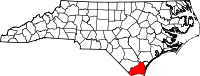
| Brunswick County, North Carolina | |
|---|---|
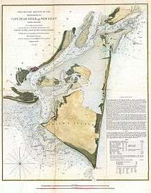 1853 U.S. Coast Survey Map of Cape Fear, North Carolina | |
 Location in the U.S. state of North Carolina | |
 North Carolina's location in the U.S. |
Corncake Inlet was a historical (channel) located on the Cape Fear region in the Brunswick County of North Carolina just south of Federal Point. [1][2] The Channel is now closed[3] and the original coordinates for Corncake Inlet placed it within the 28461 ZIP Code delivery area, and the approximate elevation is unknown above sea level. The presence of this channel dates back to 1938. [4]
Coordinates: 33.9190632°N, -77.9444314°W Category: North Carolina physical, cultural and historic features
On September 7, 1995, rip currents produced by Hurricane Luis caused the death of one person near Corncake Inlet, North Carolina.[1] High waves and high tides, caused significant beach erosion and coastal flooding. In Brunswick County, eight homes were washed away by the waves, and 40 feet (12 m) of the beach was lost. Total losses in North Carolina amounted to approximately $1.9 million.
Since then, the entire coastal plain of the east coast has experienced a constant rise in sea level and rose dramatically between 2011 and 2015. [5] [6]
In 1998, Corncake Inlet was officially shoaled and closed due to the damages of Hurricane Bonnie. [7]
Before Corncake Inlet was closed, it was noted as a shad fishing location. [8]
References
- ↑ https://www.nps.gov/parkhistory/online_books/rec_area_survey/atlantic-gulf/nc.htm
- ↑ https://ncseagrant.ncsu.edu/coastwatch/previous-issues/2000-2/high-season-2000/a-ferry-tale-for-all-seasons/
- ↑ http://www.ncwildlife.org/Portals/0/Boating/documents/NCCoastalBoatingGuideMap_multi.pdf
- ↑ https://www.gpo.gov/fdsys/pkg/CZIC-gb459-4-h57-1974/pdf/CZIC-gb459-4-h57-1974.pdf A Historical Review of Some of North Carolina's Coastal Inlets
- ↑ https://www.scientificamerican.com/article/sea-level-rise-is-speeding-up-in-parts-of-the-southeastern-u-s/
- ↑ http://news.ufl.edu/articles/2017/08/east-coasts-rapidly-rising-seas-explained.php
- ↑ http://www.allaboutwilmington.com/pages/pleasure_island
- ↑ https://www.gpo.gov/fdsys/pkg/CZIC-sh167-s5-a44-1990/html/CZIC-sh167-s5-a44-1990.htm