Huguenot station
Huguenot | ||||||||||||||||||||||||||||||||||||||||||||||||||||||||||||||||||||||||||||||||||||||||||||||||||||||||||||||||||||||||||||||||||||||||||||||||||||||||
|---|---|---|---|---|---|---|---|---|---|---|---|---|---|---|---|---|---|---|---|---|---|---|---|---|---|---|---|---|---|---|---|---|---|---|---|---|---|---|---|---|---|---|---|---|---|---|---|---|---|---|---|---|---|---|---|---|---|---|---|---|---|---|---|---|---|---|---|---|---|---|---|---|---|---|---|---|---|---|---|---|---|---|---|---|---|---|---|---|---|---|---|---|---|---|---|---|---|---|---|---|---|---|---|---|---|---|---|---|---|---|---|---|---|---|---|---|---|---|---|---|---|---|---|---|---|---|---|---|---|---|---|---|---|---|---|---|---|---|---|---|---|---|---|---|---|---|---|---|---|---|---|---|
|
| ||||||||||||||||||||||||||||||||||||||||||||||||||||||||||||||||||||||||||||||||||||||||||||||||||||||||||||||||||||||||||||||||||||||||||||||||||||||||
 | ||||||||||||||||||||||||||||||||||||||||||||||||||||||||||||||||||||||||||||||||||||||||||||||||||||||||||||||||||||||||||||||||||||||||||||||||||||||||
| Station statistics | ||||||||||||||||||||||||||||||||||||||||||||||||||||||||||||||||||||||||||||||||||||||||||||||||||||||||||||||||||||||||||||||||||||||||||||||||||||||||
| Address |
Huguenot Avenue & West Terrace Staten Island, NY 10312 | |||||||||||||||||||||||||||||||||||||||||||||||||||||||||||||||||||||||||||||||||||||||||||||||||||||||||||||||||||||||||||||||||||||||||||||||||||||||
| Borough | Staten Island | |||||||||||||||||||||||||||||||||||||||||||||||||||||||||||||||||||||||||||||||||||||||||||||||||||||||||||||||||||||||||||||||||||||||||||||||||||||||
| Locale | Huguenot | |||||||||||||||||||||||||||||||||||||||||||||||||||||||||||||||||||||||||||||||||||||||||||||||||||||||||||||||||||||||||||||||||||||||||||||||||||||||
| Coordinates | 40°32′01″N 74°11′31″W / 40.5336°N 74.1919°WCoordinates: 40°32′01″N 74°11′31″W / 40.5336°N 74.1919°W | |||||||||||||||||||||||||||||||||||||||||||||||||||||||||||||||||||||||||||||||||||||||||||||||||||||||||||||||||||||||||||||||||||||||||||||||||||||||
| Services |
Local Express | |||||||||||||||||||||||||||||||||||||||||||||||||||||||||||||||||||||||||||||||||||||||||||||||||||||||||||||||||||||||||||||||||||||||||||||||||||||||
| Transit connections |
| |||||||||||||||||||||||||||||||||||||||||||||||||||||||||||||||||||||||||||||||||||||||||||||||||||||||||||||||||||||||||||||||||||||||||||||||||||||||
| Structure | Open-cut | |||||||||||||||||||||||||||||||||||||||||||||||||||||||||||||||||||||||||||||||||||||||||||||||||||||||||||||||||||||||||||||||||||||||||||||||||||||||
| Platforms | 2 side platforms | |||||||||||||||||||||||||||||||||||||||||||||||||||||||||||||||||||||||||||||||||||||||||||||||||||||||||||||||||||||||||||||||||||||||||||||||||||||||
| Tracks | 2 | |||||||||||||||||||||||||||||||||||||||||||||||||||||||||||||||||||||||||||||||||||||||||||||||||||||||||||||||||||||||||||||||||||||||||||||||||||||||
| Other information | ||||||||||||||||||||||||||||||||||||||||||||||||||||||||||||||||||||||||||||||||||||||||||||||||||||||||||||||||||||||||||||||||||||||||||||||||||||||||
| Opened | June 2, 1860[1] | |||||||||||||||||||||||||||||||||||||||||||||||||||||||||||||||||||||||||||||||||||||||||||||||||||||||||||||||||||||||||||||||||||||||||||||||||||||||
| Station code | 516[2] | |||||||||||||||||||||||||||||||||||||||||||||||||||||||||||||||||||||||||||||||||||||||||||||||||||||||||||||||||||||||||||||||||||||||||||||||||||||||
| Former/other names |
Bloomingview Huguenot Park | |||||||||||||||||||||||||||||||||||||||||||||||||||||||||||||||||||||||||||||||||||||||||||||||||||||||||||||||||||||||||||||||||||||||||||||||||||||||
| Station succession | ||||||||||||||||||||||||||||||||||||||||||||||||||||||||||||||||||||||||||||||||||||||||||||||||||||||||||||||||||||||||||||||||||||||||||||||||||||||||
| Next north | Annadale | |||||||||||||||||||||||||||||||||||||||||||||||||||||||||||||||||||||||||||||||||||||||||||||||||||||||||||||||||||||||||||||||||||||||||||||||||||||||
| Next south | Prince's Bay | |||||||||||||||||||||||||||||||||||||||||||||||||||||||||||||||||||||||||||||||||||||||||||||||||||||||||||||||||||||||||||||||||||||||||||||||||||||||
| ||||||||||||||||||||||||||||||||||||||||||||||||||||||||||||||||||||||||||||||||||||||||||||||||||||||||||||||||||||||||||||||||||||||||||||||||||||||||
| ||||||||||||||||||||||||||||||||||||||||||||||||||||||||||||||||||||||||||||||||||||||||||||||||||||||||||||||||||||||||||||||||||||||||||||||||||||||||
| ||||||||||||||||||||||||||||||||||||||||||||||||||||||||||||||||||||||||||||||||||||||||||||||||||||||||||||||||||||||||||||||||||||||||||||||||||||||||


Huguenot is a Staten Island Railway station in the neighborhood of Huguenot, Staten Island, New York.
History
The station opened on June 2, 1860, with the opening of the Staten Island Railway from Annadale to Tottenville.[1] The station's original name was Bloomingview,[1] named after the former town of Bloomingview, which is present day Huguenot.[3] Afterwards the station was named "Huguenot Park," which was shortened to simply "Huguenot" by the Metropolitan Transportation Authority shortly after it took control of the railway from the Baltimore and Ohio Railroad in 1971 (the MTA also shortened the name of the "Old Town Road" station to simply "Old Town" at that time).
Station layout
| G | Street level | Exit/Entrance |
| P Platforms |
Side platform, doors will open on the right | |
| Southbound | ← Tottenville toward Tottenville (Prince's Bay) | |
| Northbound | → St. George toward St. George (Annadale) → | |
| Side platform, doors will open on the right | ||
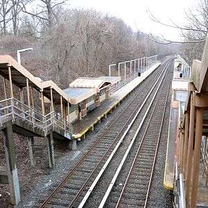
The station is located on an open cut at Huguenot Avenue and has two side platforms. There is a steel and concrete canopy over the platforms at the stairs and an additional canopy is located about halfway down the northbound platform,[4] features used as part of SIR station upgrades and platform extensions in the 1990s. Some morning rush hour local trains originate here; a pair of switches south of the station are used to reverse the direction of these trains. A spur used for ballast trains branches off the southbound track across Huguenot Avenue from the station entrance.[5][6] This stop provides access to nearby Tottenville High School.
Exit
There are exit stairs at the south end, and a brick stationhouse built in 1939 on street level.[7][8] A pedestrian overpass formerly existed at the north end. The MTA runs a park & ride lot at the station.
References
- 1 2 3 Irvin Leigh and Paul Matus (December 23, 2001). "SIRT The Essential History". p. 5. Retrieved March 3, 2009.
- ↑ "Station Developers' Information". Metropolitan Transportation Authority. Retrieved June 13, 2017.
- ↑
- ↑ Darlington, Peggy (June 2000). "Huguenot Canopies". nycsubway.org. Retrieved December 24, 2017.
- ↑ Rosenfeld, Robbie (October 16, 2013). "Track ballast loading". nycsubway.org. Retrieved December 24, 2017.
- ↑ "Part of Ward 5 Borough of Richmond Map". secretsi.com. 1873. Archived from the original on March 5, 2016. Retrieved December 24, 2017.
- ↑ Rosenfeld, Robbie (October 16, 2013). "Stationhouse". nycsubway.org. Retrieved December 24, 2017.
- ↑ "Map of NYC Subway Entrances". NYC Open Data. City of New York. Retrieved July 10, 2018.
External links
![]()