Krolevets
| Krolevets Кролевець | |||
|---|---|---|---|
 Krolevets railway station | |||
| |||
 Krolevets Location of Krolevets | |||
| Coordinates: 51°33′0″N 33°23′0″E / 51.55000°N 33.38333°E | |||
| Country region area |
Ukraine Sumy Oblast Krolevets Raion | ||
| Founded | 1601 | ||
| Population (2015) | |||
| • Total | 23,313 | ||
| Postal code | 41300 | ||
| Area code(s) | +38 (05453) | ||
| Website | http://www.krolevets.com | ||

Krolevets (Ukrainian: Кролевець, [kroɫeˈʋɛtsʲ] (![]()
History
![]()
![]()
![]()
![]()
![]()
![]()
Named in honor of the Polish King Sigismund III, Krolevets was founded in 1601 and it was originally part of Poland. The original name was written as Krolewac (Krulevats). In 1644 it was granted Magdeburg city rights by Polish King Władysław IV Vasa. Krolevets was annexed by the Tsardom of Russia in 1667 (Truce of Andrusovo). In 1897 it was incorporated into the Chernihiv province. During World War II, Krolevets was occupied by the German Army from 3 September 1941 to 1 September 1943.
Transportation
Krolevets is situated on the Kiev - Moscow railway and auto route. Distance from Kiev - approx. 260 km (161.56 mi). Distance to Russian border - approx. 80 km (49.71 mi).
Nature
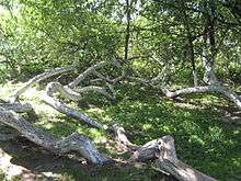
Krolevets is the location of a particularly unique apple tree, which has self-propagated into a colony of fifteen family trees that combined cover an area of 1,000 sq. meters (10,763 sq.feet).[2] This self-propagation, where drooping branches create new roots and trunks, has not been observed in other apple trees.
References
| Raions | |||||
|---|---|---|---|---|---|
| Cities |
| ||||
| |||||