Bélapátfalva District
| Bélapátfalva District Bélapátfalvai járás | ||
|---|---|---|
| Districts of Hungary | ||
| ||
 Bélapátfalva District within Hungary and Heves County. | ||
| Country |
| |
| County | Heves | |
| District seat | Bélapátfalva | |
| Area | ||
| • Total | 180.89 km2 (69.84 sq mi) | |
| Area rank | 7th in Heves | |
| Population (2011 census) | ||
| • Total | 8,978 | |
| • Rank | 7th in Heves | |
| • Density | 50/km2 (100/sq mi) | |

Bélapátfalva (Hungarian: Bélapátfalvai járás) is a district in north-eastern part of Heves County. Bélapátfalva is also the name of the town where the district seat is found. The district is located in the Northern Hungary Statistical Region. This district is a part of Bükk Mountains geographical region.
Geography
Bélapátfalva District borders with Ózd District and Kazincbarcika District (Borsod-Abaúj-Zemplén County) to the north, Miskolc District (Borsod-Abaúj-Zemplén County) to the east, Eger District to the south, Pétervására District to the west. The number of the inhabited places in Bélapátfalva District is 8.
Municipalities
The district has 1 town and 7 villages. (ordered by population, as of 1 January 2012)[1]
- Balaton (1,038)
- Bekölce (637)
- Bélapátfalva (2,996) – district seat
- Bükkszentmárton (305)
- Mikófalva (720)
- Mónosbél (416)
- Nagyvisnyó (938)
- Szilvásvárad (1,660)
The bolded municipality is city.
Demographics
Religion in Bélapátfalva District (2011 census)
In 2011, it had a population of 8,978 and the population density was 50/km².
| Year | County population[2] | Change |
|---|---|---|
| 2011 | 8,978 | n/a |
Ethnicity
Besides the Hungarian majority, the main minority is the Roma (approx. 500).
Total population (2011 census): 8,978
Ethnic groups (2011 census):[3] Identified themselves: 8,209 persons:
- Hungarians: 7,695 (93.74%)
- Gypsies: 421 (5.13%)
- Others and indefinable: 93 (1.13%)
Approx. 1,000 persons in Bélapátfalva District did not declare their ethnic group at the 2011 census.
Religion
Religious adherence in the county according to 2011 census:[4]
- Catholic – 4,246 (Roman Catholic – 4,218; Greek Catholic – 28);
- Reformed – 1,274;
- Evangelical – 20;
- other religions – 96;
- Non-religious – 1,081;
- Atheism – 65;
- Undeclared – 2,196.
Gallery
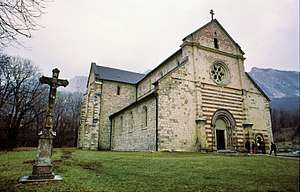 Bélapátfalva, the district seat
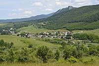 Aerial view of Mónosbél
_5.jpg) Erdődy-Pallavicini Mansion in Szilvásvárad
Erdődy-Pallavicini Mansion in Szilvásvárad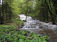 Waterfall in Szalajka Valley
See also
References
- ↑ A KSH 2012. évi helységnévkönyve
- ↑ népesség.com, "Bélapátfalvai járás népessége"
- ↑ 4.1.6.1 A népesség nemzetiség szerint, 2011, (in Hungarian)
- ↑ 4.1.7.1 A népesség vallás, felekezet szerint, 2011, (in Hungarian)
External links
| Town (1) |
| |
|---|---|---|
| Villages (7) |
| |
Coordinates: 48°03′00″N 20°19′00″E / 48.0500°N 20.3167°E