Hant's Harbour
| Hant's Harbour | ||
|---|---|---|
| Town | ||
| ||
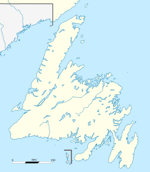 Hant's Harbour Location of Hant's Harbour in Newfoundland | ||
| Coordinates: 48°00′55″N 53°15′45″W / 48.01528°N 53.26250°WCoordinates: 48°00′55″N 53°15′45″W / 48.01528°N 53.26250°W | ||
| Country |
| |
| Province |
| |
| Population (2016) | ||
| • Total | 329 | |
| Time zone | UTC-3:30 (Newfoundland Time) | |
| • Summer (DST) | UTC-2:30 (Newfoundland Daylight) | |
| Postal Code | A0B 1Y0 | |
| Area code(s) | 709 | |
| Telephone Exchanges | 586, 591 | |
| Location |
Hant's Harbour Bay de Verde Peninsula Newfoundland Canada |
|---|---|
| Coordinates | 48°01′18.6″N 53°15′16.3″W / 48.021833°N 53.254528°W |
| Year first constructed | 1881 (first) |
| Year first lit | 1957 (current) |
| Foundation | concrete base |
| Construction | wooden tower (first and current) |
| Tower shape |
octagonal prism tower with balcony and lantern square drustum tower with balcony and lantern (current) |
| Markings / pattern | white tower, red lantern |
| Height | 9 metres (30 ft) |
| Focal height | 20 metres (66 ft) |
| Original lens | eighth-order Fresnel lens |
| Light source | solar power |
| Range | 13 nautical miles (24 km; 15 mi) |
| Characteristic | Iso W 6s. |
| Admiralty number | H0504 |
| CHS number | CCG 470 |
| NGA number | 1728 |
| ARLHS number | CAN-688 |
| Managing agent | Canadian Coast Guard[1][2] |
The community of Hant's Harbour (48°00′55″N 53°15′45″W / 48.01528°N 53.26250°W NST) is an incorporated town having a population of 346 (2011 Census) located on the east side of Trinity Bay on the Bay de Verde Peninsula, Newfoundland, Canada.
Geography
Hant's Harbour is a small fishing village built around a small harbour which opens on the north to Trinity Bay. The harbour waters are able to accommodate vessels up to 100 tons, the landscapes which surround it are low hills which are rocky and barren.
Towns and communities nearby
History
During King William's War (1688–97), the village was destroyed in the Avalon Peninsula Campaign. Like most of the early settlements around the coast of Newfoundland, the population grew very slowly during the eighteenth century.
Hant's Harbour early residents were mostly of the Church of England, during the eighteenth century they depended upon the services of clergy on the irregular visits of the missionaries for the Society of the Propagation of the Gospel, stationed at Trinity.
One of the largest reported massacres of the Beothuk people took place near Hant's Harbor, where a group armed for hunting, managed to trap a large group of Beothuks, driving them out on a peninsula, where they murdered every man, woman and child. While there is no exact count of the number killed, it is estimated to be around 400. [3]
The rise and rapid growth of Methodism in Hant's Harbour caused the Church of England community to remain small, its members being served the clergy stationed at nearby parishes. In the early twentieth century the Salvation Army came to Hant's Harbour and gradually built up a substantial membership, and constructed a citadel there.
Timeline
- 1697 - Abbe Baudoin reports that there are four houses at Hant's Harbour.
- 1801 - Five families are listed as living in Hant's Harbour.
- 1813 - T.E. and Mary Pelley die. The gravestone recording this still stands.
- 1820’s – The first known church is built in the community.
- 1830’s – The population consists of 400 people.
- 1847 – Ten vessels carrying 271 men are engaged in the seal hunt.
- 1853 – Eight vessels totalling 767 tons carry 294 men to the seal hunt.
- 1868 – 1870 – A second and much larger church is built, serving the circuit until 1907 when it is destroyed to build a new one.
- 1871 – Lovell’s Newfoundland Dictionary lists 81 of the 104 householders in Hant’s Harbour as fisherman. Two others are listed as farmers.
- 1880’s – The population grows to its peak of about 750 residents.
- 1961 – Fire destroys the vegetation which formerly covered the low hills which surround the harbour.
Climate
Relatively mild winters with considerable variation in snow cover. Heavy rainfalls from October through December. Summers cooled by low clouds and fogs near coasts, considerably brighter and warmer inland.
Economy
From the beginning the economy of Hant's Harbour was based mainly on the fisheries, until the nineteenth century when it was the inshore cod fishery and the Labrador fishery during the latter half of the century. This was also an important source of seasonal income during the nineteenth and twentieth centuries.
Attractions
- Willow Tree Museum
- Hant’s Harbour Lighthouse
- Willow Tree Fishing Stage
- Willow Tree Site
- Little Islands Hiking Trail
See also
References
- ↑ Southeastern Newfoundland The Lighthouse DirectoryUniversity of North Carolina at Chapel Hill. Retrieved 9 February 2017
- ↑ List of Lights, Pub. 110: Greenland, The East Coasts of North and South America (Excluding Continental U.S.A. Except the East Coast of Florida) and the West Indies (PDF). List of Lights. United States National Geospatial-Intelligence Agency. 2016.
- ↑ Horwood, Harold (October 10, 1959). "The people who were murdered for fun". Macleans. Toronto: MAcleans. Retrieved December 3, 2017.
External links
- Baccalieu Trail
- Historical Baccalieu Trail
- Picture of the lighthouse
- Hant's Harbour - Encyclopedia of Newfoundland and Labrador, vol. 2, p. 792-795.
- Aids to Navigation Canadian Coast Guard
