Greenpoint and Roosevelt Avenues
Route map:
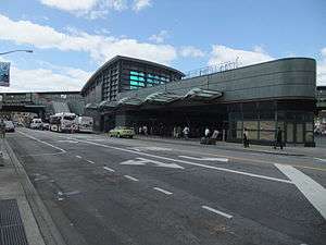 Roosevelt Avenue Bus Terminal in Jackson Heights | |
| Namesake |
Greenpoint Bluff Theodore and Franklin D. Roosevelt |
|---|---|
| Owner | City of New York |
| Maintained by | NYCDOT |
| Length |
8.3 mi[1] (13.4 km) 2.4 mi (3.86 km) as Greenpoint Avenue 5.9 mi (9.50 km) as Roosevelt Avenue |
| Location | Brooklyn, Queens |
| Postal code | 11222, 11101, 11104, 11377, 11372, 11373, 11368, 11354 |
| Nearest metro station |
Greenpoint Avenue Flushing Line Roosevelt/74th |
| West end | West Street in Greenpoint |
| Major junctions |
|
| East end |
|
Roosevelt Avenue and Greenpoint Avenue are main thoroughfares in the New York City boroughs of Queens and Brooklyn. Roosevelt Avenue begins at 48th Street and Queens Boulevard in the neighborhood of Sunnyside. West of Queens Boulevard, the road is named Greenpoint Avenue and continues across the Greenpoint Avenue Bridge into the borough of Brooklyn, terminating at WNYC Transmitter Park on the East River in the neighborhood of Greenpoint.[2] Roosevelt Avenue goes through Woodside, Jackson Heights, Elmhurst, Corona, Flushing Meadows–Corona Park (adjacent to Citi Field) and Flushing. In Flushing, Roosevelt Avenue ends at 156th Street and Northern Boulevard.[1]
The 7 and <7> trains run on the elevated IRT Flushing Line tracks above the street with ten stations until it reaches Flushing – Main Street, its current eastern terminus.[3] The rail line has been elevated above Roosevelt Avenue since 1917, when Roosevelt Avenue was formed from the combination of other streets into one main avenue.[4][5] The street, itself named after Theodore Roosevelt and Franklin D. Roosevelt,[5] provides the name for the Roosevelt Avenue / 74th Street station (7, E, F, M, and R trains) in Jackson Heights. The G train stops at the Greenpoint Avenue station located at Greenpoint Avenue and Manhattan Avenue. Roosevelt Avenue was nationally recognized for its cuisine when Good Magazine named it one of "America's Tastiest Streets".[6] Roosevelt Avenue is well known for its diversity of cultural representation, ranging from Indian to Latin American.[7]
References
- 1 2 Google (January 9, 2017). "Greenpoint and Roosevelt Avenues" (Map). Google Maps. Google. Retrieved January 9, 2017.
- ↑ http://www.nyc.gov/html/dot/html/bridges/green.shtml
- ↑ Fernandez, Manny. "Track Work Disrupts Service on No. 7 Train in Queens." The New York Times, January 13, 2008. https://www.nytimes.com/2008/01/13/nyregion/13subway.html?_r=1&oref=slogin. Access Date September 13, 2008.
- ↑ Kilgannon, Corey. "Under the Elevated Track, a New Sensation: Silence." The New York Times, December 21, 2005. https://www.nytimes.com/2005/12/21/nyregion/nyregionspecial3/22quietcnd.html Access Date September 13, 2008.
- 1 2 Mbugua, Martin. "Make Tracks to Big Avenue." New York Daily News, August 3, 1999. http://www.nydailynews.com/archives/ny_local/1999/08/03/1999-08-03_make_tracks_to_big_avenue_it.html%5Bpermanent+dead+link%5D Access Date September 13, 2008.
- ↑ America's Tastiest Streets. Matthews, Adam. February 28, 2008. http://www.goodmagazine.com/section/Features/americas_tastiest_streets
- ↑ "Queens for a Day." Village Voice, December 28, 1999. http://www.villagevoice.com/content/printVersion/505427. Access Date September 13, 2008.