Grayson, Saskatchewan
| Grayson | |
|---|---|
| Village | |
| Village of Grayson | |
 Grayson Location of Grayson in Saskatchewan  Grayson Grayson (Canada) | |
| Coordinates: 50°42′25″N 102°39′40″W / 50.707°N 102.661°W | |
| Country |
|
| Province |
|
| Region | South-central |
| Census division | 5 |
| Rural Municipality | Grayson No. 184 |
| Post office Founded | 1906 |
| Government | |
| • Type | Municipal |
| • Governing body | Grayson Village Council |
| • Mayor | Tyson Lowenberg |
| • Administrator | Colleen Stinson |
| • MP | Robert Kitchen |
| • MLA | Dan D'Autremont |
| Area | |
| • Total | 1.87 km2 (0.72 sq mi) |
| Population (2016) | |
| • Total | 211 |
| • Density | 112.9/km2 (292/sq mi) |
| Time zone | UTC-6 (CST) |
| Postal code | S0A 1E0 |
| Area code(s) | 306 |
| Highways |
|
| Railways | Abandoned |
| [1][2][3][4] | |
Grayson is a village within the Rural Municipality of Grayson, in the province of Saskatchewan, Canada. The village had a population of 211 in the 2016 Canada Census, (a 14.7% increase from 184 in the 2011 Canada Census).
Grayson celebrated its 100th anniversary in 2006.
Demographics
| Canada census – Grayson, Saskatchewan community profile | |||
|---|---|---|---|
| 2016 | 2011 | 2006 | |
| Population: | 211 (+14.7% from 2011) | 184 (+2.8% from 2006) | 104 (-14.8% from 2001) |
| Land area: | 1.87 km2 (0.72 sq mi) | 1.87 km2 (0.72 sq mi) | 1.47 km2 (0.57 sq mi) |
| Population density: | 112.9/km2 (292/sq mi) | 98.5/km2 (255/sq mi) | 121.5/km2 (315/sq mi) |
| Median age: | 51.8 (M: 50.4, F: 52.7) | 56.3 (M: 54.8, F: 56.8) | 56.5 (M: 54.5, F: 59.0) |
| Total private dwellings: | 117 | 111 | 112 |
| Median household income: | $Not Available | ||
| References: 2016[5] 2011[6] 2006[7] earlier[8] | |||
Economy
Like many small Saskatchewan communities Grayson was built along a railway which no longer exists. It no longer has a grain elevator, but a few unique businesses and its proximity to Melville still allow it to prosper, particularly a meat plant (source of the famous 'Grayson Sausage').
Grayson also possesses a post office, modern grocery/cafe, hardware store, plumbers, tavern, elementary school, village and Rural Municipality offices, business services and computer technical services. There is also a dance hall, a seniors center, and apartments for rent. Until 2017, when the Saskatchewan Transportation Company was discontinued, it had a bus drop-off and pickup.
See also
References
- ↑ National Archives, Archivia Net, Post Offices and Postmasters, archived from the original on 2006-10-06
- ↑ Government of Saskatchewan, MRD Home, Municipal Directory System, archived from the original (– Scholar search) on November 21, 2008
- ↑ Canadian Textiles Institute. (2005), CTI Determine your provincial constituency, archived from the original on 2007-09-11
- ↑ Commissioner of Canada Elections, Chief Electoral Officer of Canada (2005), Elections Canada On-line, archived from the original on 2007-04-21
- ↑ "2016 Community Profiles". Canada 2016 Census. Statistics Canada. February 21, 2017. Retrieved 2017-03-15.
- ↑ "2011 Community Profiles". Canada 2011 Census. Statistics Canada. July 5, 2013. Retrieved 2012-10-30.
- ↑ "2006 Community Profiles". Canada 2006 Census. Statistics Canada. March 30, 2011. Retrieved 2009-02-24.
- ↑ "2001 Community Profiles". Canada 2001 Census. Statistics Canada. February 17, 2012.
External links
- 2006 Community Profiles
- GeoNames Query
- Post Offices and Postmasters - ArchiviaNet - Library and Archives Canada
- Saskatchewan City & Town Maps
- Saskatchewan Gen Web Region
- Saskatchewan Gen Web - One Room School Project
- Saskatchewan Roman Catholic Churches ~ Online Parish Registers ~ History >> Nieven / Grayson - Killaly.
- Online Historical Map Digitization Project
Places adjacent to Grayson, Saskatchewan | ||||||||||
|---|---|---|---|---|---|---|---|---|---|---|
| ||||||||||
| Subdivisions | |
|---|---|
| Communities | |
| Cities | |
| Topics |
|
| |
| Cities | 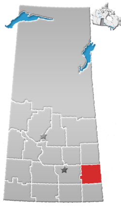 | ||
|---|---|---|---|
| Towns | |||
| Villages | |||
| Resort villages | |||
| Rural municipalities | |||
| First Nations | |||
| Indian reserves | |||
| Unincorporated communities |
| ||
Coordinates: 50°42′25″N 102°39′40″W / 50.707°N 102.661°W