Grayrigg Forest
| Grayrigg Forest | |
|---|---|
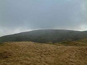 Grayrigg Forest from further west on Grayrigg Common | |
| Highest point | |
| Elevation | 494 m (1,621 ft) |
| Prominence | 190 m (620 ft) |
| Parent peak | High Street |
| Listing | Marilyn |
| Coordinates | 54°23′31″N 2°37′14″W / 54.39208°N 2.6206°WCoordinates: 54°23′31″N 2°37′14″W / 54.39208°N 2.6206°W |
| Geography | |
 Grayrigg Forest | |
| OS grid | SD598998 |
| Topo map | OS Landranger 97 |
Grayrigg Forest is a hill in England,[1] located on the eastern edge of what might be considered the Lake District, and in August 2016 becoming part of the national park. Reaching 494 metres above sea level,[2] it is attainable from the less well-known Borrowdale valley.
From near the summit, there are impressive views down into the gorge of the Lune valley, where road, West Coast Main Line railway, M6 motorway and River Lune crowd between the outliers of the Lake District and the Howgill Fells.
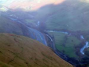
The Lune valley with M6 motorway and West Coast Main Line railway from near the summit of Grayrigg Forest
References
- ↑ Ordnance Survey: Landranger map sheet 97 Kendal & Morecambe (Windermere & Lancaster) (Map). Ordnance Survey. 2014. ISBN 9780319232088.
- ↑ "Grayrigg Forest". www.themountainguide.co.uk. Retrieved 15 March 2016.
Marilyns of Northern England | ||
|---|---|---|
| 1. Northumberland | 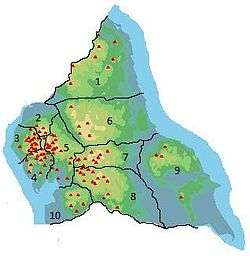 | |
| 2. Northern Lakeland | ||
| 3. Western Lakeland | ||
| 4. Central and Southern Lakeland | ||
| 5. Eastern Lakeland | ||
| 6. North Pennines and Durham | ||
| 7. Northern Yorkshire Dales | ||
| 8. Southern Yorkshire Dales | ||
| 9. North York Moors to the Humber | ||
| 10. Forest of Bowland | ||
This article is issued from
Wikipedia.
The text is licensed under Creative Commons - Attribution - Sharealike.
Additional terms may apply for the media files.