Gobindpur, Jharkhand
| Gobindpur गोविन्दपुर | |
|---|---|
| Census Town | |
 Gobindpur Location in Jharkhand, India 23°50′19″N 86°31′7″E / 23.83861°N 86.51861°E.<  Gobindpur Gobindpur (India) | |
| Coordinates: 23°50′19″N 86°31′7″E / 23.83861°N 86.51861°ECoordinates: 23°50′19″N 86°31′7″E / 23.83861°N 86.51861°E | |
| Country |
|
| State | Jharkhand |
| District | Dhanbad |
| CD block | Govindpur |
| Elevation | 188 m (617 ft) |
| Population (2011) | |
| • Total | 11,318 |
| Languages | |
| • Official | Hindi, English, Bengali |
| Time zone | UTC+5:30 (IST) |
| Vehicle registration | JH |
| Website |
dhanbad |
Gobindpur is a census town in Govindpur CD Block in Dhanbad district in the Indian state of Jharkhand.
Geography
Gobindpur is located at 23°50′19″N 86°31′7″E / 23.83861°N 86.51861°E.[1]It has an average elevation of 188 metres (616 feet).
The Dhangi Hills (highest peak 385.57 m) run from Pradhan Khunta to Gobindpur.[2][3]
Police station
Gobindpur police station serves Govindpur CD Block.[4]
CD Block HQ
Headquarters of Govindpur CD Block is at Gobindpur. [5]
Demographics
As per 2011 Census of India Gobindpur had a population of 11,318, of which 5,950 were males and 5,368 females. Scheduled Castes numbered 869 and Scheduled Tribes numbered 56.[6]
As of 2001 India census,[7] Gobindpur had a population of 8,504. Males constitute 54% of the population and females 46%. Gobindpur has an average literacy rate of 65%, higher than the national average of 59.5%: male literacy is 73%, and female literacy is 55%. In Gobindpur, 15% of the population is under 6 years of age.
Literacy
As per 2011 census the total number of literates in Gobindpur was 8,014 out of which 4,588 were males and 3,246 were females.[6]
History
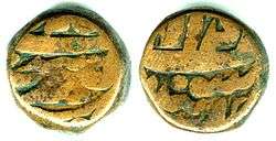
Gobindpur was a mint town in the Mughal era. Copper coins were produced during the reigns of Akbar and Jahangir.
Economy
The following collieries function under the Govindpur Area of BCCL: Kharkhari, Maheshpur, Jogidih, Kooridih, Govindpur, S/Govindpur, Teturiya and Akash Kinaree.[8]
The Govindpur Area was formed with thirty-one collieries taken over from the private sector.[9]
Transport
It is the junction point of NH 19 (old number: NH 2) and NH 18 (old number: NH 32).
References
- ↑ "Govindpur High School Dhanbad". Jharkhand. Wikimapia. Retrieved 21 December 2015.
- ↑ "Chapter III - Study Area: Dhanbad District" (PDF). Pages 38-43. Shodganga. Retrieved 8 October 2017.
- ↑ "gztr 2.Chapter I (General) 1-38" (PDF). Pages 2-5. Jharkhand Government. Retrieved 8 October 2017.
- ↑ "Dhanbad – Welcome to the Coal Capital of India". Administrative Structure of Dhanbad District – List of Thana and Outpost of Dhanbad Outpost. Jharkhand Government. Retrieved 15 October 2017.
- ↑ "District Census Handbook 2011 Series 21 Part XIIB" (PDF). Map on Page 3. Directorate of Census Operations, Jharkhand. Retrieved 8 October 2017.
- 1 2 "2011 Census C.D. Block Wise Primary Census Abstract Data(PCA)". Jharkhand – District-wise CD Blocks. Registrar General and Census Commissioner, India. Retrieved 21 December 2015.
- ↑ "Census of India 2001: Data from the 2001 Census, including cities, villages and towns (Provisional)". Census Commission of India. Archived from the original on 2004-06-16. Retrieved 2008-11-01.
- ↑ "Dhanbad - Coal Capital of India". List of Coal Mines in Dhanbad. Jharkhand Government. Retrieved 8 October 2017.
- ↑ "Bharat Coking Coal Limited". Govindpur Area. BCCL. Retrieved 8 October 2017.