Sundarijal
| Sundarijal सुन्दरीजल | |
|---|---|
| Village of Gokarneshwar Municipality | |
.jpg) The waterfall Sweet Sixteen, Sundarijal, Nepal | |
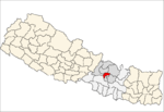
 Sundarijal Location in Nepal | |
| Coordinates: 27°43′46.20″N 85°24′23.45″E / 27.7295000°N 85.4065139°ECoordinates: 27°43′46.20″N 85°24′23.45″E / 27.7295000°N 85.4065139°E | |
| Country |
|
| Province | No. 3 |
| District | Kathmandu District |
| Area | |
| • Total | 5.18 km2 (2.00 sq mi) |
| Population (2001) | |
| • Total | 2,586 |
| • Density | 500/km2 (1,300/sq mi) |
| Time zone | UTC+5:45 (Nepal Time) |
| Postal code | 44603 |
| Area code(s) | 01 |
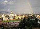
Sundarijal is a village and former Village Development Committee that is now part of Gokarneshwar Municipality in Kathmandu District in Province No. 3 of central Nepal.
History
The VDC was named after the Hindu goddess, Sundarimai. There is a temple dedicated to her in Sundarijal.[1]
In 1960, leaders from the Nepali Congress party B.P. Koirala (then prime minister), Ganesh Man Singh, Krishna Prasad Bhattarai, Diwan Singh Rai, Ram Narayan Mishra, Yogendra Man Sherchan, and Jaman Singh Gurung were taken to the Sundarijal Military Detention Camp. They were held there without trial for eight years due to their participation in a 1960 coup.[2]
Geography and climate
Geographical situation
.JPG)
Sundarijal is located 15 kilometres (9 mi) northeast of Nepal's capital, Kathmandu. It is west of Gagalphedi, east of Nayapati and Baluwa, and north of Aalapot. The VDC touches Nuwakot and Sindhulpalchok Districts to the north.[1]
Sundarijal covers an area of 5.18 square kilometres (2 sq mi). The Bagmati River flows through the VDC, where it is joined by the Shyalmati and Nagmati rivers. Largely hilly in its terrain with few flat areas, the VDC is covered by forests. Shivapuri National Park covers large amounts of Sundarijal.[1]
Climate
The climate of Sundarijal is temperate. The average temperature in summer is 25.5˚C and 0˚C in winter.[1]
Demographics
At the time of the 2011 Nepal census Sundarijal had a population of 2,552 living in 547 individual households.[3] For the 2001 census Sundarijal had a population of 2,586 in 444 individual households. Sixty percent of the townsfolk are Buddhist and 40% are Hindu.[1]
Below are the populations and households of Sundarijal's nine wards:
| Ward | Households | Male | Female | Total |
|---|---|---|---|---|
| 1 | 30 | 86 | 88 | 174 |
| 2 | 104 | 278 | 295 | 573 |
| 3 | 51 | 117 | 118 | 235 |
| 4 | 54 | 113 | 136 | 249 |
| 5 | 37 | 149 | 105 | 254 |
| 6 | 32 | 89 | 86 | 175 |
| 7 | 35 | 95 | 105 | 200 |
| 8 | 35 | 175 | 132 | 307 |
| 9 | 66 | 209 | 210 | 419 |
| 444 | 1311 | 1275 | 2586[1] |
Economy
Agriculture
.JPG)
Agriculture in the VDC is only present in the eighth ward. There farmers only use traditional techniques without modern technology. In the northern part of the ward, the predominant crops are millet and maize, though barley and some vegetables are also cultivated. In the southern area, wheat, barley, maize, potato, vegetables and millet are grown.[1]
Tourism
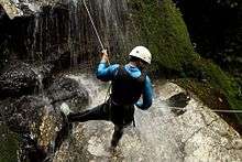
Tourism is a large industry in Sundarijal. It is a famous place for canyoning.
Large numbers of tourists crowd the VDC every weekend, attracted to the area's natural beauty, the waterfalls, and the rivers. Many come from the Kathmandu Valley because of its closeness; it is only about an hour's drive away. There are several picnic tables to meet the needs of tourists.[1]
Pollution in the Sundarijal reservoir has increased due to the number of tourists.[4]
In addition, the VDC is a starting point for hikers along the Langtang Range. Various trekking routes also lie in Sundarijal, among them the famous Sundarijal-to-Chisapani trek, almost 22 km long.[5]
Culture
The main cultural sites in Sundarijal are the temples of Sundarimai Mandir, Ganesh Mandir, and Krishna Mandir. In July, the Dashahara festival is celebrated at bodies of water near the temples.[1]
The National Scout Training Center here is also a tourist attraction.
Infrastructure
A 640 kW hydropower plant near the bus park provides electricity to Sundarijal. A mail post and police station are also located here.[1]
There is a US$464 million drinking-water project in Sundarijal that will bring water from Melamchi, treat, and distribute it. A pipeline 58 kilometres (36 mi) in length will be laid in Sundarijal to other places in the Kathmandu Valley.[6] It will start pumping 170 million liters of water daily in 2011 or 2012.[7]
Education
About 90% of townsfolk can read or write, though less than that number are fully literate. Those under the age of 25 years are more likely to be literate than those over 40. Literacy classes for older adults were taught in the past though, due to low attendance, they are no longer.[1]
There are four schools in Sundarijal, whose attendance is shown below:
| # | Male | Female | Total |
|---|---|---|---|
| 1 | 214 | 200 | 414 |
| 2 | 57 | 44 | 101 |
| 3 | 90 | 67 | 157 |
| 4 | 70 | 57 | 127 |
| 431 | 368 | 799[1] |
Biodiversity
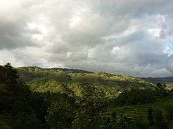
Sundarijal's vegetation consists of mostly pine, oak, rhododendron, and other forest types. Wildlife recorded in the area include the Himalayan black bear, leopard, jungle cat, and rhesus monkey. The area around Sundarijal is the habitat of 177 species of birds, which includes at least nine threatened species, 102 species of butterflies with several endangered species, and 129 species of mushrooms.[1]
References
- 1 2 3 4 5 6 7 8 9 10 11 12 13 Khadka, R.B. (2005). "Integrative Microdevelopment in Sundarijal?". Nepal Study Center. University of New Mexico. Retrieved 2008-10-06.
- ↑ "Picture of Sundarijal Military Detention Camp". Nepali Congress. Archived from the original on 2002-08-02. Retrieved 2008-10-07.
- ↑ "Archived copy" (PDF). Archived from the original (PDF) on 2013-07-31. Retrieved 2013-07-31.
- ↑ Phuyal, Surendra (2001-06-03). "Put on your hiking boots and..." Sunday Post. The Kathmandu Post. Archived from the original on December 24, 2005. Retrieved 2008-10-08.
- ↑ "Sundarijal Hiking".
- ↑ ""Exorbitant" land price obstructs Melamchi Project". The Rising Nepal. 2002-02-10. Archived from the original on October 7, 2006. Retrieved 2008-10-08.
- ↑ Sangraula, Bikash (2007-03-09). "ADB to trim Melamchi by US $114m". eKantipur. Retrieved 2008-10-08.