Ghardaïa Province
| Ghardaïa Province ولاية غرداية | |
|---|---|
| Province | |
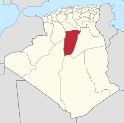 Map of Algeria highlighting Ghardaïa | |
| Coordinates: 32°29′N 3°40′E / 32.483°N 3.667°ECoordinates: 32°29′N 3°40′E / 32.483°N 3.667°E | |
| Country |
|
| Capital | Ghardaïa |
| Government | |
| • PPA president | Mr. Fekhar Mohamed (FLN) |
| • Wāli | Mr. Fehim Yehia |
| Area | |
| • Total | 86,105 km2 (33,245 sq mi) |
| Population (2008)[1] | |
| • Total | 375,988 |
| • Density | 4.4/km2 (11/sq mi) |
| Time zone | UTC+01 (CET) |
| Area Code | +213 (0) 29 |
| ISO 3166 code | DZ-47 |
| Districts | 9 |
| Municipalities | 13 |
Ghardaïa (Arabic: ولاية غرداية) is a province (wilaya) in southern Algeria, named after its capital Ghardaïa. The M'Zab Valley, located there, is a UNESCO World Heritage Site.
Administrative divisions
The province is made up of 9 districts, which are divided into 13 communes or municipalities.
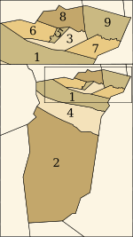
Districts
Communes
References
- ↑ Office National des Statistiques, Recensement General de la Population et de l’Habitat 2008 Archived July 24, 2008, at the Wayback Machine. Preliminary results of the 2008 population census. Accessed on 2008-07-02.
External links
- (in French) Official website
Capital: Ghardaïa | ||
| Ghardaïa District | 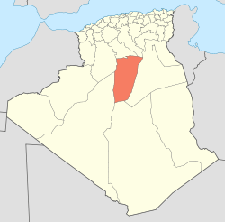 | |
| Bérianne District | ||
| Bounoura District | ||
| Dhayat Ben Dhahoua District | ||
| El Guerrara District | ||
| El Ménia District | ||
| Mansourah District | ||
| Métlili District | ||
| Zelfana District | ||
| ||
This article is issued from
Wikipedia.
The text is licensed under Creative Commons - Attribution - Sharealike.
Additional terms may apply for the media files.