Germignaga
| Germignaga | |
|---|---|
| Comune | |
| Comune di Germignaga | |
 | |
 Germignaga Location of Germignaga in Italy | |
| Coordinates: 46°0′N 8°44′E / 46.000°N 8.733°ECoordinates: 46°0′N 8°44′E / 46.000°N 8.733°E | |
| Country | Italy |
| Region | Lombardy |
| Province | Province of Varese (VA) |
| Frazioni | Ronchetto, Ronchi, Fornace, Casa Moro, Premaggio and Mirandola Nuova |
| Area | |
| • Total | 6.2 km2 (2.4 sq mi) |
| Elevation | 204 m (669 ft) |
| Population (Dec. 2004) | |
| • Total | 3,721 |
| • Density | 600/km2 (1,600/sq mi) |
| Demonym(s) | Germignaghesi |
| Time zone | UTC+1 (CET) |
| • Summer (DST) | UTC+2 (CEST) |
| Postal code | 21010 |
| Dialing code | 0332 |
| Website | Official website |
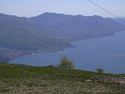
Germignaga is a comune (municipality) in the Province of Varese in the Italian region Lombardy, located about 70 km northwest of Milan and about 20 km northwest of Varese. As of 31 December 2004, it had a population of 3,721 and an area of 6.2 km².[1]
The municipality of Germignaga contains the frazioni (subdivisions, mainly villages and hamlets) Ronchetto, Ronchi, Fornace, Casa Moro, Premaggio and Mirandola Nuova.
Germignaga borders the following municipalities: Brezzo di Bedero, Brissago-Valtravaglia, Cannero Riviera, Luino, Montegrino Valtravaglia.
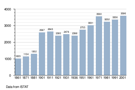
Demographic evolution
Noted Germignaga people
- Pier Giacomo Pisoni, historian
References
External links


This article is issued from
Wikipedia.
The text is licensed under Creative Commons - Attribution - Sharealike.
Additional terms may apply for the media files.