Cremenaga
| Cremenaga | |
|---|---|
| Comune | |
| Comune di Cremenaga | |
 Cremenaga Location of Cremenaga in Italy | |
| Coordinates: 45°59′N 8°48′E / 45.983°N 8.800°ECoordinates: 45°59′N 8°48′E / 45.983°N 8.800°E | |
| Country | Italy |
| Region | Lombardy |
| Province | Province of Varese (VA) |
| Frazioni | Sasso del Castello, Mirabello, Campagna, Monte Sette Termini (i Bedeloni), Cascina Porsù |
| Area | |
| • Total | 4.6 km2 (1.8 sq mi) |
| Elevation | 281 m (922 ft) |
| Population (Dec. 2004) | |
| • Total | 780 |
| • Density | 170/km2 (440/sq mi) |
| Demonym(s) | Cremenaghesi |
| Time zone | UTC+1 (CET) |
| • Summer (DST) | UTC+2 (CEST) |
| Postal code | 21030 |
| Dialing code | 0332 |
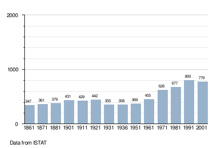
Cremenaga is a comune (municipality) in the Province of Varese in the Italian region Lombardy, located about 60 kilometres (37 mi) northwest of Milan and about 20 kilometres (12 mi) north of Varese, on the border with Switzerland. As of 31 December 2004, it had a population of 780 and an area of 4.6 square kilometres (1.8 sq mi).[1]
The municipality of Cremenaga contains the frazioni (subdivisions, mainly villages and hamlets) Sasso del Castello, Mirabello, Campagna, Monte Sette Termini (i Bedeloni), and Cascina Porsù.
Cremenaga borders the following municipalities: Cadegliano-Viconago, Cugliate-Fabiasco, Luino, Monteggio (Switzerland), Montegrino Valtravaglia.
Demographic evolution
References

This article is issued from
Wikipedia.
The text is licensed under Creative Commons - Attribution - Sharealike.
Additional terms may apply for the media files.