Curiglia con Monteviasco
| Curiglia con Monteviasco | ||
|---|---|---|
| Comune | ||
| Comune di Curiglia con Monteviasco | ||
 | ||
| ||
 Curiglia con Monteviasco Location of Curiglia con Monteviasco in Italy | ||
| Coordinates: 46°3′N 8°48′E / 46.050°N 8.800°ECoordinates: 46°3′N 8°48′E / 46.050°N 8.800°E | ||
| Country | Italy | |
| Region | Lombardy | |
| Province | Varese (VA) | |
| Frazioni | Curiglia, Monteviasco, Sarona, Alpone, Piero, Viasco, Mulini, Alpe Polusa, Alpe Fontanella, Alpe Cortetti, Alpe Cà del Sasso, Madonna della Guardia, Alpe Rattaiola, Alpe Corte, Alpe Merigetto, Ponte di Piero, Alpe rivo, Alpe Pian Cavurico, Monte Lema | |
| Government | ||
| • Mayor | Ambrogio Rossi | |
| Area | ||
| • Total | 11.3 km2 (4.4 sq mi) | |
| Elevation | 670 m (2,200 ft) | |
| Population (Dec. 2004)[1] | ||
| • Total | 189 | |
| • Density | 17/km2 (43/sq mi) | |
| Demonym(s) | Curigliesi | |
| Time zone | UTC+1 (CET) | |
| • Summer (DST) | UTC+2 (CEST) | |
| Postal code | 21010 | |
| Dialing code | 0332 | |
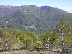
Curiglia con Monteviasco is a comune (municipality) in the Province of Varese in the Italian region Lombardy, located about 110 kilometres (68 mi) northwest of Milan and about 70 kilometres (43 mi) northwest of Varese in the Val Veddasca, on the border with Switzerland. The municipal seat is in Curiglia.
References

This article is issued from
Wikipedia.
The text is licensed under Creative Commons - Attribution - Sharealike.
Additional terms may apply for the media files.