Geography of Ottawa
This is the outline of the geography of the city of Ottawa, the capital of Canada. Ottawa's current borders were formed in 2001, when the former city of Ottawa amalgamated with the ten other municipalities within the former Regional Municipality of Ottawa-Carleton. Ottawa is now a single-tiered Census division, home to 870,250 people.
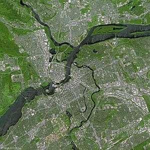
The city centre is located at the confluence of the Ottawa and Rideau Rivers. The Ottawa River forms the entire northern boundary of the city which it shares with the province of Quebec's municipalities of Pontiac and Gatineau. The northern boundary begins in the west at Arnprior and continues east to Rockland. The boundary then turns south in a straight line, separating the former Township of Cumberland (now in Ottawa) and the City of Clarence-Rockland. It then turns west in another straight line separating the former Township of Cumberland with the municipalities of The Nation and Russell. It then turns south separating Russell from the former Township of Osgoode (now in Ottawa). That boundary runs south in a straight line, then turns west separating Osgoode from the municipality of North Dundas. That boundary runs west in a straight line before turning north separating Osgoode from the municipality of North Grenville. This is another straight line, running north until the Rideau River near Kemptville. The boundary follows the River upstream until almost reaching Merrickville. The boundary then runs in a northwest direction in a straight line with a number of jogs. It separates the municipalities of Montague, Beckwith and Mississippi Mills from the former townships of Marlborough, Goulbourn, Huntley and Fitzroy.
Former townships
What is now Ottawa was once divided geographically into 11 townships. Ten of them in the former Carleton and one (Cumberland) in the former Russell County. The ten townships of Carleton were Fitzroy, Gloucester, Goulbourn, Huntley, March, Marlborough, Nepean, North Gower, Osgoode and Torbolton.
Physical geography
The highest point in the city is 166 m (545 ft) above sea level, and is located 2.6 km SSE of Manion Corners (45° 14' 5" N; 76° 3' 3" W). The lowest point in the city is the Ottawa River, at 44m above sea level.
Highest points by ward

| Ward | Highest point | Elevation (approx.) |
|---|---|---|
| West Carleton-March Ward | 2.6 km SSE of Manion Corners | 166m |
| Rideau-Goulbourn Ward | Jinkinson Road, 8 km N of Munster | 153m |
| Kanata South Ward | Glen Cairn Reservoir | 131m |
| College Ward | Khymer Ct, 1 km N of Fallowfield | 129m |
| Stittsville Ward | Rockson Cres. | 128m |
| Kanata North Ward | Huntsville Dr, Kanata Lakes | 126m |
| Osgoode Ward | 1 km SE of Bank Street & Rideau Road, South Gloucester | 120m+ |
| Cumberland Ward | Cumberland Ridge Dr, Quigley Hill | 120m+ |
| Barrhaven Ward | Cedarview Road, Cedar Hill Estates | 120m+ |
| Gloucester-Southgate Ward | Tom Roberts Ave, Macdonald-Cartier International Airport | 119m |
| Knoxdale-Merivale Ward | Cedarview Road at Cedarhill Drive | 115m+ |
| River Ward | Carlington Hill, (Carlington Heights Reservoir, Carlington Park) Carlington | 115m+ |
| Bay Ward | Corkstown Road, Ottawa - Nepean Tent & Trailer Park | 114m |
| Gloucester-South Nepean Ward | Osgoode Link Pathway (former CPR) & High Rd, 4 km SW of Leitrim | 114m |
| Innes Ward | 200m WSW of Forest Ridge Pumping Station | 114m |
| Beacon Hill-Cyrville Ward | Quarry Park, Rothwell Heights | 113m |
| Rideau-Rockcliffe Ward | Foxview Pleasant, Quarries | 106m |
| Alta Vista Ward | Alta Vista (Alta Vista Drive & Randall Ave) | 102m |
| Capital Ward | Bank Street & Alta Vista Drive | 96m |
| Orleans Ward | Clearcrest Cres, Fallingbrook | 93m |
| Kitchissippi Ward | Maitland Avenue Bridge (over the Queensway) | 89m |
| Somerset Ward | Parliament Hill | 86m |
| Rideau-Vanier Ward | Richelieu Park, Vanier | 75m+ |
Geology of Ottawa
Many features of geologic interest are found in and surrounding Ottawa. [1]
| Site | Feature |
|---|---|
| W. Erskine Johnston Elementary School | Glacially sculpted Precambrian gneiss that displays foliation, folds and cross-cutting dykes |
| Centrum parking lot | Nepean and March Formations sandstone and dolostone |
| Stony Swamp Conservation Area | Sedimentary structures in Paleozoic strata |
| Champlain Bridge | Stromatolite fossils in plan view |
| Westboro Beach | Stromatolites, orthocones and trace fossils |
| OC Transitway at Roosevelt Ave | Stromatolite fossils in cross-section |
| Tunney's Pasture | Gloucester Fault in cross-section |
| Geological Survey of Canada, 601 Booth St. | Fossiliferous limestone |
| Hog's Back Falls | Ordovician sedimentary rocks and the Gloucester Fault |
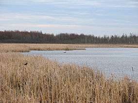
| Mer Bleue Bog | Boreal peatland |
| Lemieux Landslide | Leda Clay landslide, 1993 |
| Parc Brébeuf, Gatineau | Fossiliferous limestone bedrock and glacial erratics |
| Victoria Island | Dune bedforms and fossiliferous limestone |
| Champlain Lookout, Gatineau Park | Precambrian bedrock and Eardley Fault escarpment |
| Cantley quarry, Québec | Outcrops of Precambrian marble shaped in part by sub-glacial hydraulic scouring |
| Lac des Fées Trail, Gatineau Park | Limestones from a depositional environment of shallowing water depths |
| Lady Grey Dr. behind Royal Canadian Mint | Limestones from a depositional environment of episodic storms |
| Parc du Lac Beauchamp, Québec | Precambrian-Cambrian contact exposed |
| Pinhey's Point | Sandstone, limestone and glacial erratics at an historic homestead |
| Petrie Island | Modern shoreline processes and the geology of imported blocks |
| Metcalfe Geoheritage Park, Almonte | An assemblege of rocks that are representative of regional geology |
| Burnt Lands Alvar, Almonte | Barren limestone plain that hosts rare vegetation |
| Outcrop along HWY 307, near Cantley | Gneiss exhibiting folding, faulting, partial melting and intrusion by dykes |
| Building Stones and Monuments of Downtown Ottawa | |
| Pinhey Sand Dunes | |
| Cardinal Creek Karst |
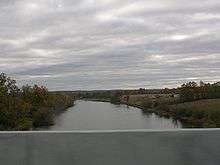
Rivers and creeks
- Tributaries of the Ottawa River (from east to west)

- Becketts Creek
- Cardinal Creek
- Bilberry Creek
- Green's Creek
- Mud Creek
- Borthwick Creek
- Nicolet Drain
- Ramsay Creek
- McEwen Creek
- Rideau River
- Rideau Canal (artificial)
- Graham Creek
- Still Water Creek
- Watts Creek
- Shirley's Brook
- Constance Creek
- Carp River
- Mississippi River
- Cartwrights Creek
- Cody Creek
- Madawaska River (mouth not in Ottawa)
- Tributaries of the Rideau River (from north to south)

- Sawmill Creek
- Nepean Creek
- Black Rapids Creek
- Mosquito Creek
- Jock River
- Mahoney Creek
- Nichols Creek
- Kings Creek
- Mud Creek
- Steven Creek
- Cranberry Creek
- McDermot Drain (mouth not in Ottawa)
- Brassills Creek
- Rideau Creek
- Others
- Bear Brook
- South Indian Creek
- Shaws Creek
- McKinnons Creek
- North Castor River
- Black Creek
- Middle Castor River
- South Castor River
Features of the Ottawa River

(from East to West)
- Petrie Island
- Lower Duck Island
- Upper Duck Island
- Governor Bay
- Nepean Point
- Victoria Island
- Chaudière Island
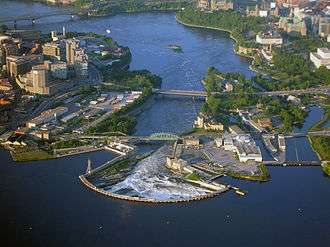
- Chaudière Falls
- Nepean Bay
- Lemieux Island
- Bell Island
- Merrill Island
- Nicholas Island
- Lazy Bay
- Little Chaudière Rapids
- Remic Rapids
- Bate Island
- Cummingham Island
- Riopelle Island
- Deschênes Rapids
- Britannia Bay
- Graham Bay
- Rocky Point
- Crystal Bay
- Beatty Point
- Shirleys Bay
- Haycock Island
- Chartrand Island
- Innis Point
- Aylmer Island
- Pinhey Point
- Stony Point
- Horseshoe Bay
- Constance Bay
- Sand Point
- Buckham's Point
- Buckham's Bay
- Crown Point
- Woolsey Narrows
- Alexandra Island
- Kedey's Island
- Chats Falls
- Morris Island
- Lavergne Point
- Lavergne Bay
- Pickerel Bay
- Snake Island
- Indian Point
- Marshall Bay
- Pocket Bay
- Goodwin Bay
Features of the Rideau River

(from North to South)
- Rideau Falls
- Green Island
- Maple Island
- Porter Island
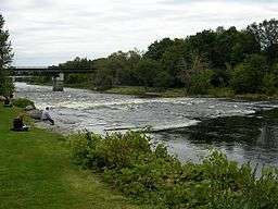
- Hog's Back Falls (Prince of Wales Falls)
- Mooney's Bay
- Black Rapids
- Nicholls Island
- Long Island
- Mahogany Harbour
- Collins Point
- Sanders Island
- James Island
- McGahey's Bend
Lakes
- Brewer Park Pond (Ottawa)
- Constance Lake (Kanata)
- Lac des Chats (West Carleton)
- Dow's Lake (artificial, Ottawa)
- Lac Deschênes (Nepean)
- Lake Madawaska (West Carleton)
- McKay Lake (Rockcliffe Park)
- Mud Lake (Britannia)
- Mud Pond (Kanata)
- Sand Pits Lake (Rockcliffe Park)
Other geographical features
- Beaver Island (West Carleton)
- The Burnt Lands (West Carleton)
- Canaan Hill (Cumberland)
- Carlington Hill (Carlington)
- Carp Hills (also known as Carp Ridge) (West Carleton)
- Colonel By Valley (Ottawa)
- Greenbelt (Nepean/Gloucester)
- Mer Bleue (Cumberland/Gloucester)
- Pine Grove Forest
- Stony Swamp
- LeBreton Flats (Ottawa)
- Marlborough Forest (Rideau-Goulbourn Ward)
- Nanny Goat Hill (Ottawa)
- Quigley Hill (Cumberland)
Sources
- National Resources Canada Topographic Maps
- MapArt map of Ottawa
- Ontario Base Survey
References
- ↑ "Ottawa-Gatineau Geoheritage". Retrieved 2018-10-04.
External links
| History | |
|---|---|
| Geography | |
| Culture | |
| Public services | |
| Education | |
| Government | |
| Transportation | |
| Features | |
| |
| Infrastructure | |
|---|---|
| Sport in Ottawa | |
| Entertainment and festivals | |
| Museums |
|
| Parks, squares, and natural landmarks | |
| Historical | |
| Demolished structures | |
| Shopping | |
| Neighbourhoods | |
| |