Pontiac, Quebec
| Pontiac | |
|---|---|
| Municipality | |
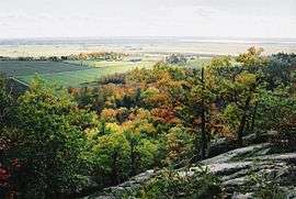 Pontiac as seen from the Gatineau Hills | |
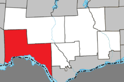 Location within Les Collines-de-l'Outaouais RCM. | |
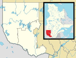 Pontiac Location in western Quebec. | |
| Coordinates: 45°35′N 76°08′W / 45.583°N 76.133°WCoordinates: 45°35′N 76°08′W / 45.583°N 76.133°W[1] | |
| Country |
|
| Province |
|
| Region | Outaouais |
| RCM | Les Collines-de-l'Outaouais |
| Constituted | January 1, 1975 |
| Government[2] | |
| • Mayor | Joanne Labadie |
| • Federal riding | Pontiac |
| • Prov. riding | Pontiac |
| Area[2][3] | |
| • Total | 504.60 km2 (194.83 sq mi) |
| • Land | 448.31 km2 (173.09 sq mi) |
| Population (2011)[3] | |
| • Total | 5,681 |
| • Density | 12.7/km2 (33/sq mi) |
| • Pop 2006-2011 |
|
| • Dwellings | 2,659 |
| Time zone | UTC−5 (EST) |
| • Summer (DST) | UTC−4 (EDT) |
| Postal code(s) | J0X 2G0, J0X 2V0 |
| Area Code | 819 |
| Highways |
|
| Website |
www |
Pontiac is a municipality in western Quebec, Canada, on the north shore of the Ottawa River, in the Outaouais region of the Ottawa Valley. It was created by the 1975 amalgamation of the communities of Onslow, Eardley, Quyon and Onslow-Partie-Sud.[1] Pontiac is located within Canada's National Capital Region.
It is part of Les Collines-de-l'Outaouais Regional County Municipality. It should not be confused with Pontiac Regional County Municipality, which borders Pontiac (but does not include it).
According to Statistics Canada, in 2011, the population's native language was 55.7% French, 39% English, and 2.6% other languages, including German, Arabic, Spanish, Dutch, and Russian. Approximately three out of five people are bilingual, with 63% speaking both French and English.[4]
Pontiac has a low cost of living and is trying to attract new immigrants coming to Canada to improve the local economy. The unemployment rate is 11%.
Communities
- Breckenridge
- Eardley
- Heyworth
- Luskville
- Quyon
See also
References
- 1 2 Reference number 72506 of the Commission de toponymie du Québec (in French)
- 1 2 Geographic code 82030 in the official Répertoire des municipalités (in French)
- 1 2 "(Code 2482030) Census Profile". 2011 census. Statistics Canada. 2012.
- ↑ http://www12.statcan.gc.ca/census-recensement/2011/as-sa/fogs-spg/Facts-csd-eng.cfm?LANG=Eng&GK=CSD&GC=2482030
- ↑ http://www.municipalitepontiac.com/files/1913/6674/0150/Carte_routire_Pontiac_-_ActualisationF4_reu_le_23_avril_2013.pdf
| Municipalities | |
|---|---|
| |