Lebesby
| Lebesby kommune Davvesiidda gielda Lebespyyn komuuni | |||||
|---|---|---|---|---|---|
| Municipality | |||||
 View of the Ifjordfjellet in Lebesby | |||||
| |||||
 Lebesby within Finnmark | |||||
| Coordinates: 70°56′43″N 27°21′04″E / 70.94528°N 27.35111°ECoordinates: 70°56′43″N 27°21′04″E / 70.94528°N 27.35111°E | |||||
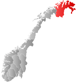
| Country | Norway | ||||
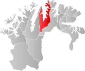
| County | Finnmark | ||||
| District | Øst-Finnmark | ||||
| Established | 1 Jan 1838 | ||||
| Administrative centre | Kjøllefjord | ||||
| Government | |||||
| • Mayor (2010) | Stine Akselsen (Ap) | ||||
| Area | |||||
| • Total | 3,459.41 km2 (1,335.69 sq mi) | ||||
| • Land | 3,232.32 km2 (1,248.01 sq mi) | ||||
| • Water | 227.09 km2 (87.68 sq mi) 6.7% | ||||
| Area rank | #8 in Norway | ||||
| Population (2017) | |||||
| • Total |
1,330 ( | ||||
| • Rank | #367 in Norway | ||||
| • Density | 0.4/km2 (1/sq mi) | ||||
| • Change (10 years) | -2% | ||||
| Demonym(s) | Lebesbyværing[1] | ||||
| Time zone | UTC+01:00 (CET) | ||||
| • Summer (DST) | UTC+02:00 (CEST) | ||||
| ISO 3166 code | NO-2022 | ||||
| Official language form | Bokmål | ||||
| Website |
lebesby | ||||


Lebesby (Northern Sami: Davvesiida and Kven: Lebespyy) is a municipality in Finnmark county, Norway. The administrative centre of the municipality is the village of Kjøllefjord. Other villages in the municipality include Ifjord, Kunes, Lebesby, and Veidnes.
The 3,459-square-kilometre (1,336 sq mi) municipality is the 8th largest by area out of the 422 municipalities in Norway. Lebesby is the 367th most populous municipality in Norway with a population of 1,330. The municipality's population density is 0.4 inhabitants per square kilometre (1.0/sq mi) and its population has decreased by 2% over the last decade.[2]
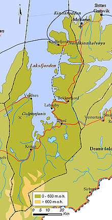
The municipality consists of the western half of the Nordkinn Peninsula, along with areas around the Laksefjorden. Most people live in the village of Kjøllefjord. This municipality is dominated by ethnic Norwegians, whereas the areas around the Laksefjorden are predominantly Sami. Fishing is the mainstay of the population.
General information
The parish of Lebesby was established as a municipality on 1 January 1838 (see formannskapsdistrikt). In 1864, the eastern part of Lebesby that surrounds the Tanafjorden (population: 1,388) was separated to become the new municipality of Tana. Tana was later separated into Tana, Gamvik, and Berlevåg. The borders of Lebesby have remain unchanged since that time.[3]
Name
Lebesby is may be a Norwegianized form of a Northern Sami name Leaibbessiida. The first element is then derived from leaibi which means "alder" and the last element is siida which means "dwelling place" (Norwegian: by). The other possible option is the at Lebesby is a corruption of the Old Norse Liðvarðsbýr. That name is made up of Liðvarð, a man's name, and býr which also means "dwelling place" (Norwegian: by).[4][5]
Coat of arms
The coat of arms is from modern times; they were granted on 22 July 1988. The arms are divided yellow over black by two embattlements. The idea is that the arms represent the Finnkirka ("the Finn Church"), a cliff by the sea in the municipality. This cliff formation has the appearance of a church, and in former times was used by Sami people as a place of sacrifice.[6]
Churches
The Church of Norway has two parishes (sokn) within the municipality of Lebesby. It is part of the Hammerfest prosti (deanery) in the Diocese of Nord-Hålogaland.
| Parish (sokn) | Name | Location | Year built |
|---|---|---|---|
| Kjøllefjord | Kjøllefjord Church | Kjøllefjord | 1951 |
| Lebesby | Lebesby Church | Lebesby | 1962 |
| Kunes Chapel | Kunes | 1982 |
Government
All municipalities in Norway, including Lebesby, are responsible for primary education (through 10th grade), outpatient health services, senior citizen services, unemployment and other social services, zoning, economic development, and municipal roads. The municipality is governed by a municipal council of elected representatives, which in turn elect a mayor.[7] The municipality falls under the Øst-Finnmark District Court and the Hålogaland Court of Appeal.
Municipal council
The municipal council (Kommunestyre) of Lebesby is made up of 18 representatives that are elected to four year terms. Currently, the party breakdown is as follows:[8]
| Party Name | Name in Norwegian | Number of representatives | |
|---|---|---|---|
| Labour Party | Arbeiderpartiet | 8 | |
| Conservative Party | Høyre | 1 | |
| Green Party | Miljøpartiet De Grønne | 3 | |
| Socialist Left Party | Sosialistisk Venstreparti | 1 | |
| Local Lists | Lokale lister | 5 | |
| Total number of members: | 18 | ||
Geography
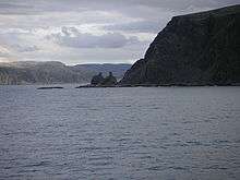
The municipality consists of the areas around the Laksefjorden, including the eastern part of the Sværholt Peninsula and the western half of the Nordkinn Peninsula. At the entrance to the Kjøllefjorden at the northwestern tip of the Nordkinn Peninsula, one finds the spectacular Finnkirka sea cliff, so named because of its soaring spires that look like a church. On the other side of the Oksefjorden on the northern end of the peninsula, the Kinnarodden cape (shared with the municipality of Gamvik) is the northernmost point on the European mainland. There are several large lakes in the municipality including Kjæsvannet, Store Måsvann, and Suolojávri.
Birdlife
The same seacliffs mentioned above hold large numbers of breeding seabirds. In fact Norway's third largest seabird colony can be found in the municipality. Experiencing a seabird colony is one of nature's great experiences, here you can see and listen to thousands of birds with such species as fulmar and Atlantic puffin being a part of a fascinating ecosystem.
Flora
The world's northernmost birch forest is located in this municipality, near Oksefjorden, 9 kilometres (5.6 mi) east of Kjøllefjord (70°58′N 27°34′E / 70.967°N 27.567°E).[9]
Climate
| Climate data for Lebesby | |||||||||||||
|---|---|---|---|---|---|---|---|---|---|---|---|---|---|
| Month | Jan | Feb | Mar | Apr | May | Jun | Jul | Aug | Sep | Oct | Nov | Dec | Year |
| Daily mean °C (°F) | −6.8 (19.8) |
−6.6 (20.1) |
−4.5 (23.9) |
−1.1 (30) |
3.5 (38.3) |
8.0 (46.4) |
11.0 (51.8) |
10.2 (50.4) |
6.5 (43.7) |
1.7 (35.1) |
−2.3 (27.9) |
−5.5 (22.1) |
1.2 (34.2) |
| Average precipitation mm (inches) | 44 (1.73) |
36 (1.42) |
30 (1.18) |
29 (1.14) |
28 (1.1) |
38 (1.5) |
57 (2.24) |
54 (2.13) |
58 (2.28) |
59 (2.32) |
45 (1.77) |
42 (1.65) |
520 (20.47) |
| Source: Norwegian Meteorological Institute[10] | |||||||||||||
References
- ↑ "Navn på steder og personer: Innbyggjarnamn" (in Norwegian). Språkrådet. Retrieved 2015-12-01.
- ↑ Statistisk sentralbyrå (2017). "Table: 06913: Population 1 January and population changes during the calendar year (M)" (in Norwegian). Retrieved 2017-09-09.
- ↑ Jukvam, Dag (1999). "Historisk oversikt over endringer i kommune- og fylkesinndelingen" (PDF) (in Norwegian). Statistisk sentralbyrå.
- ↑ Rygh, Oluf (1924). Norske gaardnavne: Finmarkens amt (in Norwegian) (18 ed.). Kristiania, Norge: W. C. Fabritius & sønners bogtrikkeri. p. 214.
- ↑ Store norske leksikon. "Lebesby" (in Norwegian). Retrieved 2013-02-22.
- ↑ "Civic heraldry of Norway - Norske Kommunevåpen". Heraldry of the World. Retrieved 2018-06-05.
- ↑ Hansen, Tore, ed. (2016-05-12). "kommunestyre". Store norske leksikon (in Norwegian). Kunnskapsforlaget. Retrieved 2018-06-05.
- ↑ "Table: 04813: Members of the local councils, by party/electoral list at the Municipal Council election (M)" (in Norwegian). Statistics Norway. 2015.
- ↑ "Verdens nordligste skog" (in Norwegian).
- ↑ "eKlima Web Portal". Norwegian Meteorological Institute. Archived from the original on 2004-06-14.
External links

- Municipal fact sheet from Statistics Norway (in Norwegian)
- About Lebesby
| |||||||||||