Franklin Township, Montgomery County, Indiana
| Franklin Township | |
|---|---|
| Township | |
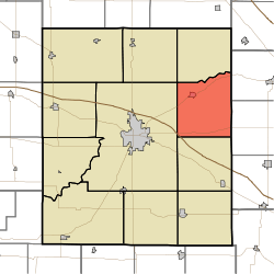 Location in Montgomery County | |
| Coordinates: 40°05′23″N 86°45′02″W / 40.08972°N 86.75056°WCoordinates: 40°05′23″N 86°45′02″W / 40.08972°N 86.75056°W | |
| Country |
|
| State |
|
| County | Montgomery |
| Government | |
| • Type | Indiana township |
| Area | |
| • Total | 38.93 sq mi (100.8 km2) |
| • Land | 38.93 sq mi (100.8 km2) |
| • Water | 0 sq mi (0 km2) 0% |
| Elevation[1] | 846 ft (258 m) |
| Population (2010) | |
| • Total | 1,915 |
| • Density | 49.2/sq mi (19.0/km2) |
| Time zone | UTC-5 (Eastern (EST)) |
| • Summer (DST) | UTC-4 (EDT) |
| ZIP codes | 46071, 47933, 47940 |
| Area code(s) | 765 |
| GNIS feature ID | 453309 |
Franklin Township is one of eleven townships in Montgomery County, Indiana, United States. As of the 2010 census, its population was 1,915 and it contained 801 housing units.[2]
Franklin Township was established in 1831.[3]
History
Darlington Covered Bridge was listed on the National Register of Historic Places in 1990.[4]
Geography
According to the 2010 census, the township has a total area of 38.93 square miles (100.8 km2), all land.[2]
Cities, towns, villages
Unincorporated towns
- Darlington Woods at 40°07′11″N 86°48′19″W / 40.119762°N 86.805284°W
- Shannondale at 40°03′17″N 86°41′44″W / 40.0547637°N 86.6955609°W
(This list is based on USGS data and may include former settlements.)
Cemeteries
The township contains Greenlawn Cemetery.
Major highways
School districts
- North Montgomery Community School Corporation
Political districts
- Indiana's 4th congressional district
- State House District 28
- State Senate District 23
References
- "Franklin Township, Montgomery County, Indiana". Geographic Names Information System. United States Geological Survey. Retrieved 2009-09-27.
- United States Census Bureau 2008 TIGER/Line Shapefiles
- IndianaMap
- ↑ "US Board on Geographic Names". United States Geological Survey. October 25, 2007. Retrieved 2017-05-09.
- 1 2 "Population, Housing Units, Area, and Density: 2010 - County -- County Subdivision and Place -- 2010 Census Summary File 1". United States Census. Retrieved 2013-05-10.
- ↑ Beckwith, Hiram Williams; Kennedy, P. S. (1881). History of Montgomery County, Together with Historic Notes on the Wabash Valley. H. H. Hill and N. Iddings. p. 521.
- ↑ National Park Service (2010-07-09). "National Register Information System". National Register of Historic Places. National Park Service.
External links
- Indiana Township Association
- United Township Association of Indiana
- City-Data.com page for Franklin Township
Places adjacent to Franklin Township, Montgomery County, Indiana | |
|---|---|
Municipalities and communities of Montgomery County, Indiana, United States | ||
|---|---|---|
| City | ||
| Towns | ||
| Townships | ||
| CDP | ||
| Other unincorporated communities | ||
| Footnotes | ‡This populated place also has portions in an adjacent county or counties | |
This article is issued from
Wikipedia.
The text is licensed under Creative Commons - Attribution - Sharealike.
Additional terms may apply for the media files.