Fort Sumner, New Mexico
| Fort Sumner, New Mexico | |
|---|---|
| Village | |
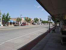
 Downtown Fort Sumner in 2003 | |
 Location of Fort Sumner, New Mexico | |
 Fort Sumner, New Mexico Location in the United States | |
| Coordinates: 34°28′23″N 104°14′32″W / 34.47306°N 104.24222°WCoordinates: 34°28′23″N 104°14′32″W / 34.47306°N 104.24222°W | |
| Country | United States |
| State | New Mexico |
| County | De Baca |
| Area | |
| • Total | 3.34 sq mi (8.66 km2) |
| • Land | 3.31 sq mi (8.58 km2) |
| • Water | 0.03 sq mi (0.08 km2) |
| Elevation | 4,032 ft (1,229 m) |
| Population (2010) | |
| • Total | 1,031 |
| • Estimate (2016)[1] | 915 |
| • Density | 310/sq mi (120/km2) |
| Time zone | UTC-7 (Mountain (MST)) |
| • Summer (DST) | UTC-6 (MDT) |
| ZIP code | 88119 |
| Area code(s) | 575 |
| FIPS code | 35-27340 |
| GNIS feature ID | 0923600 |
Fort Sumner is a U.S. village in De Baca County, New Mexico. The population was 1,031 at the 2010 U.S. Census,[2] down from 1,249 at the 2000 U.S. Census. It is the county seat of De Baca County.[3] Fort Sumner is the spring and fall home of the Columbia Scientific Balloon Facility, and is home to the burial site of famed outlaw of the American West, Billy the Kid, who was shot and killed here in 1881.
History
Named after former New Mexico Territory military governor Edwin Vose Sumner, U.S. Fort Sumner was a military fort charged with the internment of nearby Navajo and Mescalero Apache populations from 1863 to 1868. The federal government closed the fort in 1868 and sold its buildings to Lucien Maxwell, a prominent New Mexico landowner, in 1870. In the latter 1870s Maxwell's son Pete befriended legendary outlaw Billy the Kid, and it was in his house that Billy was killed by Pat Garrett. Billy the Kid is buried in the old military cemetery in Fort Sumner, as is Lucien Maxwell.
In 1866, the U.S. government was holding thousands of Native Indians at Fort Sumner after they were subdued by Kit Carson. Charles Goodnight and Oliver Loving saw a business opportunity and decided to sell beef to the United States Government so that the starving captives could be fed. This enterprise led to the establishment of the Goodnight-Loving Trail, located far enough west to avoid any contact with mobs wanting the superior Longhorn cattle.
In the 1920s the Transcontinental Air Transport airline built an airfield in Fort Sumner as part of its coast-to-coast air passenger network, but the site was abandoned when the airline's ambitious plans collapsed in the Great Depression. The airfield was reopened by the United States Army Air Forces as a training base during World War II. After the war, the base became the Fort Sumner Municipal Airport, and was chosen as a launch site for NASA's high-altitude balloon program.
Geography and climate
Fort Sumner is located northeast of the center of De Baca County at 34°28′23″N 104°14′32″W / 34.473162°N 104.242232°W,[4] on the north side of the Pecos River.
U.S. Route 60 passes through the village as Sumner Avenue, leading east 60 miles (97 km) to Clovis and west 57 miles (92 km) to Vaughn. U.S. Route 84 comes in from the north as 4th Street, leading northwest 44 miles (71 km) to Santa Rosa. US 84 runs east from Fort Sumner with US 60 to Clovis and the Texas border beyond it.
According to the United States Census Bureau, the village of Fort Sumner has a total area of 3.34 square miles (8.66 km2), of which 3.31 square miles (8.58 km2) is land and 0.03 square miles (0.08 km2), or 0.93%, is water.[2]
| Climate data for Fort Sumner, New Mexico (1981–2010) | |||||||||||||
|---|---|---|---|---|---|---|---|---|---|---|---|---|---|
| Month | Jan | Feb | Mar | Apr | May | Jun | Jul | Aug | Sep | Oct | Nov | Dec | Year |
| Average high °F (°C) | 56.3 (13.5) |
60.8 (16) |
68.5 (20.3) |
77.5 (25.3) |
85.7 (29.8) |
95.3 (35.2) |
94.4 (34.7) |
92.4 (33.6) |
86.4 (30.2) |
76.1 (24.5) |
64.6 (18.1) |
55.7 (13.2) |
76.1 (24.5) |
| Average low °F (°C) | 22.3 (−5.4) |
26.2 (−3.2) |
33.7 (0.9) |
39.7 (4.3) |
50.7 (10.4) |
60.5 (15.8) |
64.3 (17.9) |
62.9 (17.2) |
55.3 (12.9) |
42.7 (5.9) |
29.1 (−1.6) |
23.0 (−5) |
42.5 (5.8) |
| Average precipitation inches (mm) | 0.42 (10.7) |
0.41 (10.4) |
0.70 (17.8) |
0.86 (21.8) |
1.30 (33) |
1.60 (40.6) |
2.18 (55.4) |
3.22 (81.8) |
1.74 (44.2) |
1.57 (39.9) |
0.66 (16.8) |
0.60 (15.2) |
15.25 (387.3) |
| Average snowfall inches (cm) | 4.1 (10.4) |
2.9 (7.4) |
1.0 (2.5) |
0.5 (1.3) |
0.0 (0) |
0.0 (0) |
0.0 (0) |
0.0 (0) |
0.0 (0) |
0.1 (0.3) |
1.5 (3.8) |
4.9 (12.4) |
15.0 (38.1) |
| Source: NOAA[5] | |||||||||||||
Demographics
| Historical population | |||
|---|---|---|---|
| Census | Pop. | %± | |
| 1920 | 777 | — | |
| 1930 | 839 | 8.0% | |
| 1940 | 1,669 | 98.9% | |
| 1950 | 1,982 | 18.8% | |
| 1960 | 1,809 | −8.7% | |
| 1970 | 1,615 | −10.7% | |
| 1980 | 1,421 | −12.0% | |
| 1990 | 1,269 | −10.7% | |
| 2000 | 1,249 | −1.6% | |
| 2010 | 1,031 | −17.5% | |
| Est. 2016 | 915 | [1] | −11.3% |
| U.S. Decennial Census[6] | |||
As of the census[7] of 2000, there were 1,249 people, 533 households, and 312 families residing in the village. The population density was 374.6 people per square mile (144.8/km2). There were 680 housing units at an average density of 204.0 per square mile (78.8/km2). The racial makeup of the village was 81.91% White, 0.80% Native American, 0.08% Asian, 15.29% from other races, and 1.92% from two or more races. Hispanic or Latino of any race were 48.28% of the population.
There were 533 households out of which 22.9% had children under the age of 18 living with them, 45.8% were married couples living together, 9.4% had a female householder with no husband present, and 41.3% were non-families. 38.6% of all households were made up of individuals and 23.3% had someone living alone who was 65 years of age or older. The average household size was 2.21 and the average family size was 2.97.
In the village, the population was spread out with 22.4% under the age of 18, 5.6% from 18 to 24, 21.2% from 25 to 44, 19.5% from 45 to 64, and 31.3% who were 65 years of age or older. The median age was 46 years. For every 100 females, there were 92.4 males. For every 100 females age 18 and over, there were 86.3 males.
The median income for a household in the village was $19,583, and the median income for a family was $28,625. Males had a median income of $24,722 versus $16,953 for females. The per capita income for the village was $13,327. About 20.4% of families and 25.3% of the population were below the poverty line, including 33.9% of those under age 18 and 17.1% of those age 65 or over.
In popular culture
- Fort Sumner is featured in the video game, American Truck Simulator.
References
- 1 2 "Population and Housing Unit Estimates". Retrieved June 9, 2017.
- 1 2 "Geographic Identifiers: 2010 Demographic Profile Data (G001): Fort Sumner village, New Mexico". U.S. Census Bureau, American Factfinder. Retrieved November 3, 2015.
- ↑ "Find a County". National Association of Counties. Archived from the original on 2011-05-31. Retrieved 2011-06-07.
- ↑ "US Gazetteer files: 2010, 2000, and 1990". United States Census Bureau. 2011-02-12. Retrieved 2011-04-23.
- ↑ "NOWData - NOAA Online Weather Data". National Oceanic and Atmospheric Administration. Retrieved May 5, 2013.
- ↑ "Census of Population and Housing". Census.gov. Archived from the original on May 12, 2015. Retrieved June 4, 2015.
- ↑ "American FactFinder". United States Census Bureau. Archived from the original on 2013-09-11. Retrieved 2008-01-31.
External links
Municipalities and communities of De Baca County, New Mexico, United States | ||
|---|---|---|
| Village | 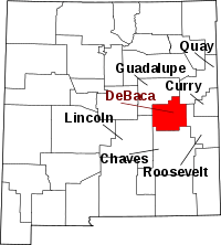 | |
| CDP | ||
| Unincorporated communities | ||
| Ghost town | ||
Santa Fe (capital) | ||
| Topics |
| |
| Society | ||
| Regions |
| |
| Cities | ||
| Counties | ||