Fort Pierre National Grassland
| Fort Pierre National Grassland | |
|---|---|
 | |
 | |
| Location | Lyman, Stanley and Jones counties, South Dakota, United States |
| Coordinates | 44°08′28″N 100°16′44″W / 44.141°N 100.279°W[1]Coordinates: 44°08′28″N 100°16′44″W / 44.141°N 100.279°W[2] |
| Area | 115,890 acres (469.0 km2)[3] |
| Governing body | U.S. Forest Service |
| Website | Fort Pierre National Grassland |
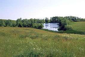
Fort Pierre National Grassland is a United States National Grassland in central South Dakota, south of the capital city Pierre and its neighbor Fort Pierre. The national grassland is primarily a short grass prairie and has a land area of 115,890 acres (46,900 ha).[3] In descending order of area it lies in parts of Lyman, Stanley, and Jones counties.[3] Part of the movie Dances with Wolves was filmed there. It is managed by the U.S. Forest Service together with the Nebraska and Samuel R. McKelvie National Forests and the Buffalo Gap and Oglala National Grasslands from common offices in Chadron, Nebraska. There is a local ranger district office located in Pierre.[4]
References
- ↑ "Fort Pierre National Grassland". Geographic Names Information System. United States Geological Survey. Retrieved December 9, 2012.
- ↑ "Fort Pierre National Grassland". Geographic Names Information System. United States Geological Survey. Retrieved December 9, 2012.
- 1 2 3 "Land Areas of the National Forest System". U.S. Forest Service. January 2013. Archived from the original on December 1, 2012. Retrieved December 9, 2012.
- ↑ "Nebraska National Forests and Grasslands". U.S. Forest Service. Retrieved December 9, 2012.
External links
- Fort Pierre National Grassland - Nebraska National Forests and Grasslands
This article is issued from
Wikipedia.
The text is licensed under Creative Commons - Attribution - Sharealike.
Additional terms may apply for the media files.