Cedar River National Grassland
| Cedar River National Grassland | |
|---|---|
 | |
 | |
| Location | Sioux and Grant counties, North Dakota, United States |
| Nearest city | Lemmon, SD |
| Coordinates | 45°57′19″N 101°50′39″W / 45.9552°N 101.8443°W[1]Coordinates: 45°57′19″N 101°50′39″W / 45.9552°N 101.8443°W[2] |
| Area | 6,717 acres (27.18 km2)[3] |
| Governing body | U.S. Forest Service |
| Website | Cedar River National Grassland |
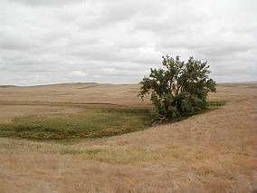
Cedar River National Grassland is a National Grassland located in Sioux County and Grant County in southern North Dakota, United States. It has a land area of 6,717 acres (2,718 ha).[3] The portion in Sioux County lies within the Standing Rock Indian Reservation. Within the grassland are topographic features such as level plains and rolling hills. Dry streams and some small flowing streams exist throughout the Grasslands.
The grassland is administered by the U.S. Forest Service as part of the Dakota Prairie Grasslands from offices in Bismarck, North Dakota. There are local ranger district offices (shared with Grand River National Grassland) in Lemmon, South Dakota.
References
- ↑ "Cedar River Motor Vehicle Use Map" (PDF). fs.fed.us. U.S. Forest Service. 2007. Retrieved March 10, 2012.
- ↑ "Cedar River Motor Vehicle Use Map" (PDF). fs.fed.us. U.S. Forest Service. 2007. Retrieved March 10, 2012.
- 1 2 "Land Areas of the National Forest System". U.S. Forest Service. January 2013. Retrieved December 8, 2012.
- Hansen, Kurt (2008). Plants of the Grand River and Cedar River National Grasslands:2008 (PDF). USDA United States Forest Service. p. 56.
External links

- Dakota Prairie Grasslands - U.S. Forest Service
This article is issued from
Wikipedia.
The text is licensed under Creative Commons - Attribution - Sharealike.
Additional terms may apply for the media files.